
Abstract
A calibrated and validated finite difference numerical model was used to estimate the spatial and temporal distribution of the Meteoric Groundwater Discharge (MGWD) and Submarine Groundwater Discharge (SGD) into a coasted estuary known as the Indian River Lagoon (IRL) at two transects. Specifically, this paper describes the methodology used to determine: a) the quantity of MGWD originating from the mainland and the barrier island, b) the spatial distribution of the SGD into the IRL, c) the groundwater salinity and hydraulic head distribution below the IRL, and d) the regional flow directions of the MGWD and the Oceanic Groundwater Discharge (OGWD) in a vertical plane below the transects. It was found that a brackish transition zone, in which groundwater salinity varies from freshwater salinity to lagoon water salinity, exists in the surficial aquifer, below the IRL, at both the Palm Bay and Titusville transects. The daily SGD flow into the IRL for each month ranged from 1.77 to 2.10 m3/d, and from 0.37 to 0.42 m3/d, per meter of lagoon shoreline, at the Palm Bay and Titusville transects, respectively. These numbers are close to the 0.45 m3/d per meter of lagoon shoreline MGWD, through a 22 m outflow face, estimated by at the Eau Gallie transect. The mainland produced 98% of the MGWD at the Palm Bay transect and 86% of the MGWD at the Titusville transect. The estimated annual MGWD were 9.0 % and 1.6 % of the annual rainfall at the Palm Bay and Titusville transects. These numbers are reasonable given the impervious character of the watersheds that discharge into the IRL at these transects. The MGWD can occur at distances of several kilometers from the groundwater divide and up to a kilometer away from the IRL shoreline, and can affect the brackish water salt concentration below the IRL. Also, it is possible that, below the lagoon, zones of meteoric ground water may occur below the brackish water at depths of 20 to 30 m as in the case of the Palm Bay transect. The MGWD appears to be the primary source of SGD into the IRL at the study transects, as no ocean water enters the lagoon, and there is virtually no tidal influence at any of the transects which implies that the reversed estuarine water discharge (REWD) is also negligible.
Keywords: Indian river lagoon; Meteoric groundwater discharge (MGWD); Submarine groundwater discharge (SGD); Numerical Modeling; Seepage; Groundwater
Introduction
In the past 20 years several researchers, using various techniques, have estimated either the submarine groundwater discharge (SGD), or different components of the SGD, into the Indian River Lagoon (IRL), which is located in coastal east-central Florida (Figure 1). The IRL is a bar-built estuary (Figure 1) which extends 250 km from Volusia County, Florida, to Palm Beach County, Florida [1]. Its width varies from 0.8 km to 8.0 km, while water depths are generally 1 m to 3 m. The IRL is hydraulically connected on the north and south ends to the Atlantic Ocean by two natural inlets known as the Ponce de Leon Inlet in Volusia County and the Jupiter Inlet in Palm Beach County. In between, it is connected to the ocean at three man-made inlets, the Sebastian Inlet, the Fort Pierce Inlet and the St. Lucie Inlet. Along the coast, the IRL is protected from the Atlantic Ocean by coastal islands known as the “barrier-island chain” (Figure 1). Traditionally, the sum of all groundwater discharge into an ocean was termed Submarine Groundwater Discharge (SGD) by several researchers [2,3]. The SGD is currently defined as “any and all flow of water on continental margins from the seabed to the coastal ocean, regardless of fluid composition or driving force” [4]. Recently, this definition has also been used in the context of other tidally influenced bodies such as coastal estuaries and lagoons [5]. Typical components of SGD could be: a) the Meteoric Groundwater Flow (MGWD), also known as terrestrial flow, which occurs primarily due to rainfall in the watershed adjoining the estuary, b) saltwater transported from the ocean termed Oceanic Groundwater Discharge (OGWD), c) water transported from lower aquifers termed as Deeper Groundwater Discharge (DGWD) in this paper, and d) estuarine water, which seeped into the aquifer during high tide in the IRL, seeping back into the estuary during low tide. The seepage of estuarine water back into the IRL is termed as Reversed Estuarine Water Discharge (REWD) in this paper. The terms OGWD, DGWD, and REWD have been introduced in this paper for convenience.
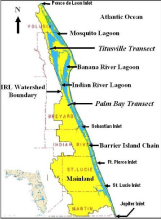
Figure 1: Indian River Lagoon (IRL) system.
A number of methods have been used to estimate the SGD into the IRL at various transects along the lagoon shoreline. For example, [1,5-10] determined the SGD into the IRL using seepage meter measurements. Swarzenski [8] also estimated the SGD using the Radium Isotope technique, while Cable et al., [10] also estimated the SGD using the Excess 222 Radium Flux Model technique. Studies which estimated the MGWD component of the SGD have been fewer. The bulk of the MGWD to the IRL comes from the watershed located on the west side of the IRL, known as “Mainland” although some seepage also occurs from the Barrier Islands located on the east side of the transects [11]. One method for distinguishing the MGWD from the other SGD components is by their respective salinity concentrations since the salinity of the “fresh” groundwater discharge is generally less than 0.5 ppm, whereas the other components have a much higher salinity. Two studies, Pandit and El-Khazen [11] and Martin et al., [1] estimated the MGWD into the IRL. Pandit and El-Khazen [11] used a finite element model to predict the MGWD component of the SGD in St. Lucie County at a transect, marked as the St. Lucie Transect in Figure 1, between the Fort Pierce and St. Lucie inlets, while Martin et al., [1] estimated the MGWD by two independent techniques (seepage meters and pore water chloride concentrations) at a transect located in Brevard County approximately 8 km north of the Palm Bay transect and marked as the Eau Gallie Transect in Figure 1. While both Pandit and El-Khazen [11] and Martin et al., [1] were able to determine the MGWD in the IRL, the scope and nature of their studies were vastly different. Martin et al., [1] estimated that the MGWD (termed terrestrial SGD by them) by examining the chloride concentration of the groundwater below the IRL up to a depth of 2 m below the sea face. They estimated that the MGWD decreased linearly to around 22 m offshore at their transect. In other words, there was no MGWD, at a depth of 2 m below the sea face, at a distance greater than 22 m from the shoreline according to their estimates. [11], on the other hand, estimated the regional flow of the MGWD [12-14], in the unconfined aquifer below the mainland and the IRL at the St. Lucie County transect. In other words, Pandit and El-Khazen [11] traced the migration of the MGWD from its origin (the water table in the mainland and barrier island) to the bed of the IRL. They determined that the encroachment of the regional MGWD is not a near-shore event, at least in the deeper regions of the aquifer. The work of Pandit et al [15], combined with the work of Pandit [16], showed that the MGWD may take place along the entire transect of the IRL, however, most of the MGWD encroachment may occur in the deeper regions of the unconfined aquifer, below the lagoon, where the MGWD mixes with the existing brackish/saline water. Therefore, measurements of groundwater salinity in the upper regions of the surficial aquifer, say at a depth of 2 m below the lagoon bed, may not show any meteoric groundwater but only saline or brackish water as found by [1]. The predictions of Pandit A, and El-Khazen CC [11], and Pandit A [16] at the St. Lucie transect, were based on results obtained from a finite element model but they had limited field data to calibrate/validate their model.
There are two significant difference between this study and the earlier studies conducted by [11,16]. First, in the present study, the modelers were able to measure the equivalent freshwater hydraulic head in the aquifer and the groundwater salinity below the lagoon to enable them to effectively calibrate the spatial distribution of the vertical hydraulic conductivity in the upper layers of the aquifer [17]. Second, there was no tidal influence at the present study transects unlike the St. Lucie transect [15], which made it easier to determine the MGWD as no REWD was present. The present study uses the well known finite difference model MODFLOW [18] instead of the finite element model used in the earlier studies although MODFLOW provided very similar groundwater seepage rates to those obtained from the finite element model at the St. Lucie transect. This paper extends the work of Pandit et al [17] by showing how the calibrated/ validated model was used to: a) estimate the quantity of MGWD originating from the mainland and the barrier island, b) estimate the spatial distribution of the SGD into the IRL, c) describe the groundwater salinity and hydraulic head distribution below the IRL, and d) provide the regional flow directions of the MGWD and the OGWD in a vertical plane below the transects.
Methods
Various field measurements were conducted to a) establish boundary conditions for the numerical model, b) to determine key model parameters, and c) to calibrate and validate the model for the purpose of determining the MGWD.
Measurements of groundwater and surface water elevations in the mainland
Monthly groundwater elevations and surface water elevations were measured at several groundwater monitoring wells and along major canals and creeks in the proximity of the Palm Bay and Titusville transects in the mainland to construct monthly groundwater contours for the purpose of estimating the water table elevations along the 6.23 km and 2.56 km extensions of the Palm Bay and Titusville transects from the IRL to the water table divide in the mainland (Segment AB in Figures 2 and 3), respectively. These water table elevations were used as boundary conditions in the numerical model. The estimated water table elevations measurements were also able to pinpoint the location of the groundwater table divide (Point A in Figures 2 and 3). Water table elevations were obtained from April, 2008, to September, 2008, at the Palm Bay transect and from October, 2007, to October, 2008, at the Titusville transect.

    Figure 2: Model domain, mesh description and boundary conditions for the
surficial aquifer at Palm Bay Transect.
AB, CD: Dirichlet Boundary: Heads specified based on measured water table
elevation.
BC: Dirichlet Boundary: Equivalent freshwater hydraulic heads specified
based on measured Lagoon elevation and salinity.
DE: Dirichlet Boundary: Equivalent freshwater hydraulic heads specified
based on MSL and ocean salinity.
AF, EF: Impermeable Boundaries.
Measurements of Lagoon Bed Profile and Model Domain - The IRL bed profile and the two-dimensional domain used to model the Palm Bay transect is shown in Figure 2. The model domain at the Palm Bay transect extends 9.75 km in the east-west direction from the Atlantic Ocean to the groundwater divide. The IRL width and the maximum depth at this transect are approximately 2.6 km and 3.6 m, respectively. The top of the Hawthorn Formation, located approximately at -33.5 m NGVD, serves as the bottom of the model domain. The Hawthorn Formation, which consists of several layers of impervious marl and clay [19] and has a thickness of approximately 10 to 30 m at the Palm Bay and Titusville transect locations, was considered as an impervious surface in the model. The IRL bed profile and the two-dimensional domain used to model the Titusville transect are shown in Figure 3. The model domain at the Titusville transect extends 19.81 km in the east-west direction from the Atlantic Ocean to the groundwater divide. The width and the maximum depth of the IRL at this transect are approximately 2.0 km and 4 m, respectively. The respective width of the Barrier Island at the Palm Bay and Titusville transects are 914 m and 305 m. In addition, the Titusville transect also includes a 1.5 km long tract of the National Wildlife Refuge which supports a high number of endangered and threatened species, and a 3.05 km long tract of the Mosquito Lagoon shown in Figure 1.
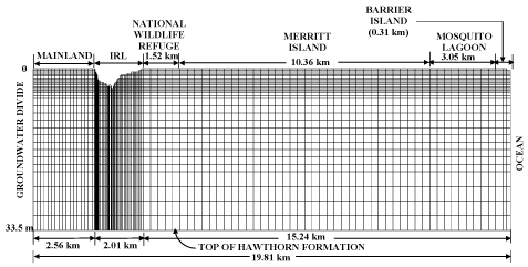
    Figure 3: Model domain, mesh description and boundary conditions for the
surficial aquifer at Titusville Transect.
AB, CD: Dirichlet Boundary: Heads specified based on measured water table
elevation.
BC, DE: Dirichlet Boundary: Equivalent freshwater hydraulic heads specified
based on measured Lagoon elevation and salinity.
EF: Dirichlet Boundary: Equivalent freshwater hydraulic heads specified
based on MSL and ocean salinity.
AG, FG: Impermeable Boundaries.
Salinity and piezometric head measurements
Salinity measurements were made at a minimum of seven locations, spread across the entire transect, for the purposes of a) determining the groundwater salinity distribution below the IRL b) for estimating the freshwater hydraulic head, and c) for model calibration and validation. At each location, the measurements were made at two depths ranging from 0.5 to 6.1 m below the IRL bed [17,20]. During the study period, groundwater salinities, at the measured locations, varied from 0.1 to 30.8 ppt at the Palm Bay transect and from 7.6 to 37 ppt at the Titusville transect. The IRL salinities during the same period varied from 9.6 to 32.1 parts ppt at the Palm Bay transect and from 21.1 to 36.2 ppt at the Titusville transect. Although the salinity data were collected in the region marked ABCD on Figures 4a and 4b, the Inverse Distance Weighted Method using the Gradient Plane nodal function [21,22] was used to extrapolate the data to construct typical equi-salinity contours at the Palm Bay and Titusville transects, shown in Figures 4a and 4b, respectively. The equi-salinity contours were constructed after normalizing the groundwater salinity with respect to the ocean water salinity. Thus, 0.7 in these figures represents a salinity of 0.7 times that of ocean water. Groundwater piezometric heads were also measured at the same locations where salinity was measured. Measured piezometric heads were made compatible with each other by converting them to equivalent freshwater hydraulic heads as proposed by Lusczynski [23] using salinity values which were also measured at the exact same locations as the piezometric heads. Description of measurement locations, frequency of measurements, and measurement techniques are described by [17,20]. Freshwater hydraulic head distributions below the IRL in the form of equipotential lines were also determined by the Inverse Distance Weighted Method and typical distributions are shown in Figures 5a and 5b (bottom figure) for both the Palm Bay and Titusville transects, respectively.

    Figure 4: Location of Estuarine Aquifer Transition Zone (EATZ) at a) the
Palm Bay Transect on June 26 b) the Titusville Transect on June 13; salinity
data was measured within the segment ABCD; ocean salinity = 1.0; Note:-
WS: west shore; ES: east shore.
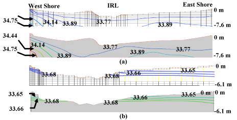
    Figure 5: Comparison of model simulated (top figure) and field measured
(bottom figure) equipotential lines (based on equivalent freshwater hydraulic
heads.) below the Indian River Lagoon at a) Palm Bay Transect on June 26,
2008; and b) Titusville Transect on July 9, 2008. The top of the Hawthorn
Formation, 33.5 m below NGVD, was used as the datum.
A number of interesting observations can be made from Figures 4 and 5. Both Figures 4a and 4b show that a brackish transition zone, in which groundwater salinity varies from freshwater salinity to lagoon water salinity, exists in the surficial aquifer, below the IRL, at both the Palm Bay and Titusville transects. This brackish transition zone is similar to the brackish transition zone that exists near the ocean boundaries [24,25]. This transition zone, below the estuary, will be termed the estuarine-aquifer transition zone (EATZ) in this paper to distinguish it from the transition zone that exists near the ocean boundary. A comparison of Figures 4a and 4b shows that the depth, width and the location of the EATZ is different at the two transects. At the Palm Bay transect, the EATZ is located completely across the transect and it is approximately 19.8 m deep in the middle of the lagoon. On the other hand, there is only a narrow EATZ on the east shore of the IRL at the Titusville transect. The width of the EATZ is only 100 m and it extends to a depth of 6.1 m. While a transition zone also exists on the west shore of the IRL at the Titusville transect, the relative salinity (fraction) variation within this transition zone is from 0.7 to 1.0. Since the equi-salinity contours in Figures 4a and 4b were extended below the region where data were taken, it is not clear exactly what quality water exists below the EATZ at the two transects. It appears that there may be freshwater and saltwater in the lower regions of the aquifer at the Palm Bay and Titusville transects, respectively. The presence of the EATZ implies a downward migration of the salt water from the estuary into the underlying aquifer either through advection or dispersion. An examination of the measured equivalent freshwater equipotential lines in Figures 5a and 5b (bottom figures) shows that the direction of groundwater is upward into the IRL at both transects. Therefore, it is likely that the downward migration of the saltwater is primarily due to dispersion of salt from the IRL into the surficial aquifer. The differences in the location and shape of the EATZ below the two transects is very likely due to the magnitude and spatial distribution of the MGWD into the surficial aquifer.
Horizontal and vertical hydraulic conductivity measurements
At each transect, the horizontal or lateral hydraulic conductivity distribution, Kh, below the IRL bed was determined by collecting soil samples at 7 locations, uniformly spread across the transect, at depths of 0.3 and 1.5 m for a total of 14 samples per transect. Sieve analyses were conducted on the samples and Kh was obtained using Hazen’s equation (Kh = Cd102; [26]). The Kh values ranged from 10 to 54 m/day at the Palm Bay transect and were indicative of medium to coarse sand, while they ranged from 7 to 12.5 m/day at the Titusville transect which are indicative of fine to medium sand. The vertical hydraulic conductivity (Kv) distribution in the vertical plane was obtained by model calibration and validation at both transects [17]. The details regarding model calibration and validation have been described by [17] although sample comparisons of sample modelpredicted and measured equi-potential lines at the Palm Bay and Titusville transects are shown in Figures 5a and 5b, respectively. Model calibration indicated that the predominant Kv value was 0.015 m/day for both transects although Kv ranged from 0.0015 to 0.015 m/day at the Palm Bay transect, and from 0.00015 to 0.015 m/day at the Titusville transect in the upper regions of the surficial aquifer. Sensitivity analyses [17] has shown that the freshwater hydraulic head distribution in the domains at both transects was significantly influenced by Kv but showed little variation even when Kh was changed by two orders of magnitude.
Watershed characteristics
The watershed divide is 2.5 times further from the IRL at the Palm Bat transect (6.23 km) then at the Titusville transect (2.56 km), and therefore the area contributing meteoric groundwater to the west shore of the IRL is much greater at the Palm Bay transect than at the Titusville transect. The contributing watershed at the Palm Bay transect is primarily industrial or low to medium density housing with large open spaces in close proximity of IRL. The watershed next to the Titusville transect is far more impervious as it consists of medium to high density residential housing and commercial areas with virtually no open spaces.
Boundary conditions and grid
The boundary conditions for the Palm Bay and Titusville transects are shown in Figures 2 and 3, respectively. Both the groundwater divide (left boundary) and the top of the Hawthorn Formation (bottom boundary) were considered to be impermeable. Moreover, the top of the Hawthorn Formation was considered to be horizontal at both transects. Although there is a possibility that the Hawthorn Formation may conduct groundwater from the confined Floridian aquifer below the Hawthorn Formation to the surficial aquifer, previous studies [11,17,27] have shown that excellent model calibration and validation was possible with this assumption. AB and CD (Figures 2 and 3) were treated as Dirichlet boundaries and hydraulic heads were specified based on measured water table elevations. BC and DE (Figures 2 and 3) were also treated as Dirichlet boundaries, however, the measured piezometric head was converted to equivalent freshwater hydraulic head using the following equation:
h = z + [(γs – γf)C + γf ][γf (hs -z)] (1)
in which h = equivalent freshwater hydraulic head, hs = measured saltwater piezometric head, C = normalized saltwater concentration with respect to ocean water (C = 1 for ocean water), z = distance from top of the Hawthorn Formation to the mid screen level of the piezometer, and γs and γf = are the respective unit weights of salt and fresh water. The finite difference grid was refined at some locations ensure that nodes existed at the measurement stations to conveniently compare model predicted and measured equivalent hydraulic head values.
Model Results
Flow directions of SGD, MGWD and OGWD into the IRL
A Groundwater Modeling System (GMS) was used with MODFLOW [18] was used to examine the flow directions of MGWD, SGD and OGWD at the Palm Bay and Titusville transects under steady state conditions. Since model calibration and validation results have been documented by [17], this paper will focus primarily on the model predicted results. The model-predicted groundwater flow directions, at the Palm Bay and Titusville transects, are shown in the form of arrows in Figures 6 and 7, respectively.
Palm bay transect
The arrows in Figure 6 indicate that the bulk of the MGWD originates from the mainland at the Palm Bay transect and a good percentage finds its way into the IRL although a much smaller portion is also discharged into the ocean. The EATZ (Region ABEF of Figure 4a) is also shown in Figure 6 to show that a vast portion of the MGWD flows upward toward the IRL, mixes with the brackish water in the EATZ, and the brackish water ultimately flows into the IRL. The MGWD, originating from the Barrier Island, discharges both into the ocean and the IRL. In addition, the ocean discharges salt water into the lower regions of the aquifer (Figure 6). This discharge, typically known as oceanic groundwater recharge (OGWR), mixes with the brackish water in the aquifer, and discharges back into the ocean from the upper regions of the aquifer (Figure 6). The ocean water discharging back into the ocean is termed oceanic groundwater discharge (OGWD) in this paper (Figure 6). The SGD discharge into the IRL at this transect comprises mainly of the MGWD from the Mainland and the Barrier Island although the water is brackish by the time it gets to the lagoon. The daily SGD flow into the IRL for each month ranged from 1.77 to 2.10 m3/d per meter of lagoon shoreline at the Palm Bay transect, with an average daily discharge of 1.95 m3/d per meter of lagoon shoreline. Model estimations for June showed that 2.01 m3/d/m of MGWD originated from the Mainland, and all of it discharged into the IRL. The MGWD originating from the Barrier Island was 0.16 m3/d/m of which 0.12 m3/d/m (75%) discharged into the ocean while 0.04 m3/d/m (25%) discharged into the IRL. The total discharge into the IRL was 2.05 m3/d/m with the Mainland contributing 98% of the discharge. The OGWR during this period was 0.16 m3/d/m, and it combined with the 0.12 m3/d/m of MGWD from the Barrier Island to provide an OGWD value of 0.28 m3/d/m. The total amount of groundwater entering and leaving the surficial aquifer was 2.34 m3/d/m and water balance was maintained in all estimations.
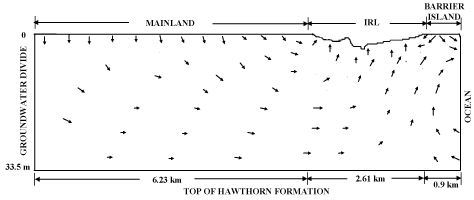
    Figure 6: Groundwater flow velocity vectors at the Palm Bay Transect
for June 26, 2008. (Arrows are not to scale and are used mainly to show
direction).
Titusville transect
The groundwater flow directions at the Titusville transect (Figure 7) clearly show that all MGWD originating from the mainland discharges into the IRL, although it mixes with the brackish water in the EATZ (Region ABEF of Figure 6) before discharging into the IRL. The MGWD originating from the Barrier Island discharges into the Mosquito Lagoon and the ocean and does not reach the IRL. The groundwater originating from Merritt Island partly discharges into the National Wildlife Refuge on the west coast of the lagoon and partly into the IRL. The ocean water (OGWR) discharges back into the ocean although some of it may discharge into the Mosquito Lagoon. Thus, the discharge into the IRL originates mainly from the Mainland at this transect. The daily SGD flow into the IRL for each month ranged from 0.37 to 0.42 m3/d per meter of lagoon shoreline at the Titusville transect, with an average daily discharge of 0.40 m3/d per meter of lagoon shoreline. Model estimations for July, at the Titusville transect, showed that 0.32 m3/d/m of MGWD originated from the Mainland, and all of it discharged into the IRL. The MGWD originating from Merritt Island was 0.13 m3/d/m of which 0.08 m3/ d/m (61%) discharged into the Mosquito Lagoon while 0.05 m3/d/m (39%) discharged into the IRL. The total SGD into the IRL was 0.37 m3/d/m with the Mainland contributing 86% of the discharge. The OGWR during this period was 0.19 m3/d/m, and almost all of it is going into the Mosquito Lagoon since the OGWD value was only 0.02 m3/d/m at this transect. The total amount of groundwater entering and leaving the surficial aquifer was 0.64 m3/d/m and water balance was maintained in all estimations.
Spatial distribution of SGD along the transects
The model-simulated spatial distributions of submarine groundwater flux (volume per unit day per unit area) into the IRL at the Palm Bay transect on June 26, 2008 (pre Tropical Storm Fay) and September 1, 2008 (post Tropical Storm Fay), are shown in Figure 8. The storm during Tropical Fay brought in approximately 37 cm of rain at the study sites over a 48 hour period (August 20 and 21). Figure 8 shows that the spatial distribution of the SGD, discharging into the west shore of the IRL, is highly non-uniform along the transect with sharp dips and peaks although it gradually decreases towards the middle of the lagoon and becomes negligible approximately 1600 m from the west shore of the IRL. This type of non-uniform distribution, with areas discharging relatively large amounts of groundwater into the IRL, has been noticed by other researchers including [8]. A much smaller SGD occurs on the east shore of the IRL up to a distance of approximately 400 m from the east shore of the IRL. Similar observations can be made for the Titusville transect (Figure 9) where the SGD into the IRL occurs up to a distance of 1 km from the west shore of the IRL. There is virtually negligible discharge from the east shore of the IRL at this transect.
Monthly and annual MGWD seepage rates
The model-simulated daily submarine groundwater discharges into the IRL, per unit length of shoreline, for different months, are shown in Figure 10. The average daily SGD flow into the IRL for each month, at the Palm Bay transect, ranged from 1.77 to 2.10 m3/d per meter of lagoon shoreline during the six month period from April to September 2008, while the average daily SGD flowing into the lagoon, during this period, was 1.95 m3/d per meter of lagoon shoreline. Although the MGWD was not always proportional to the amount of rainfall, in general, the seepage rate increased during the “wet” months from May to August (Figure 9) at the Palm Bay transect. At times, the MGWD decreased during large storm events since the IRL elevation rose faster than the adjoining water table elevations during these events. The average daily SGD into the IRL, for the 12 month period from October 2007 to September 2008, at the Titusville transect, showed an even narrower range from 0.37 to 0.42 m3/d per meter of lagoon shoreline, with an average of 0.40 m3/d per meter and a standard deviation of 0.01 m3/d per meter. These averages were extrapolated to estimate annual SGD discharges into the IRL to be 712 m3 and 146 m3 per meter of shoreline at the Palm Bay and Titusville transects, respectively.
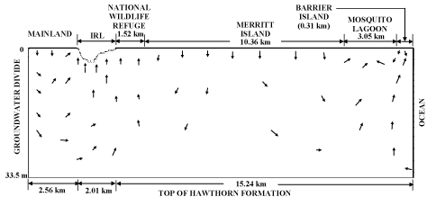
    Figure 7: Groundwater flow velocity vectors at the Palm Bay Transect for
July 9, 2008. (Arrows are not to Scale and are used mainly to show direction).
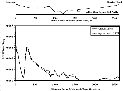
    Figure 8: Spatial distribution of Submarine Groundwater Discharge (SGD) to
the Indian River Lagoon at the Palm Bay Transect.
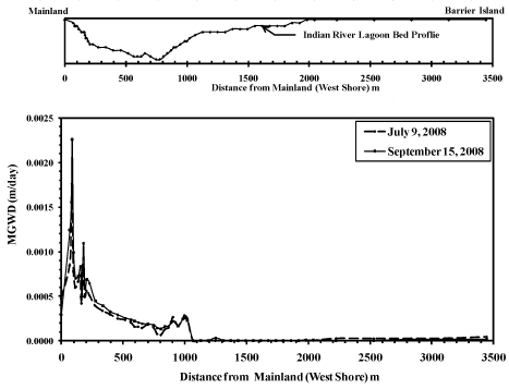
    Figure 9: Spatial distribution of Submarine Groundwater Discharge (SGD) to
the Indian River Lagoon at the Titusville Transect.
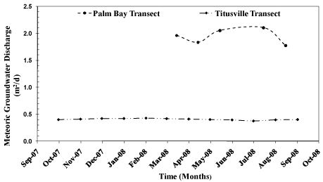
    Figure 10: Mean daily Meteoric Groundwater Discharge per unit length of
Lagoon shoreline.
Discussion and Conclusions
The meteoric groundwater and submarine groundwater discharges determined from this study provide an interesting comparison with the findings of [1] predicted a MGWD of 0.45 m3/d per meter of lagoon shoreline, through a 22 m outflow face, at the Eau Gallie transect. In this study, the SGD or MGWD (assuming they are equal) discharge for the same distance near the west shore of the IRL at the Palm Bay transect was found to be 0.12 m3/d which has the same order of magnitude as the finding [1]. However, this study estimates an average SGD discharge of 1.95 m3/d per meter of lagoon shoreline estimate for the entire Palm Bay transect whereas Martin [1] determined the SGD of approximately 117 m3/d per meter of lagoon shoreline for the entire Titusville transect. It is difficult to explain the two orders of difference in the respective findings. Based on this study results, the MGWD appears to be the primary source of SGD into the IRL at the study transects. There is no ocean discharge (OGWD) in the IRL at these transects and the likelihood of reversed estuarine water discharge (REWD) is also negligible as there is virtually no tidal influence at either the Palm Bay or Titusville transect. The model did assume that there was no discharge via the Hawthorn Formation which may not be completely accurate. It is possible that the Hawthorn Formation is not completely impermeable, as assumed in this study, and that there is an upward movement of groundwater from the deeper confined aquifer into the surficial aquifer through the Hawthorn Formation. Furthermore, it is possible that some percentage of this groundwater discharge from via the Hawthorn Formation reaches the IRL and is the reason for two orders of magnitude difference in the SGD estimates between this study and the findings of [1]. An estimate of the maximum possible upward discharge via the Hawthorn Formation can be made based on previously reported results. For example, the maximum possible head difference across the Hawthorn Formation and the minimum possible thickness of the Hawthorn Formation at the Palm Bay transect are 12.2 m and 61 m [19], respectively. Also, the vertical hydraulic conductivity of the Hawthorn Formation in the proximity of the Palm Bay transect is reported as 8.63*10-4 m/d [27]. Given that the transect length is 2.6 km, application of Darcy’s Law estimates a maximum recharge of 0.41 m3/d per meter of lagoon shoreline via the Hawthorn Formation. Even if it is assumed that the entire recharge via the Hawthorn Formation reaches the Indian River Lagoon, it is not possible to compensate for the two orders of magnitude difference between the SGD estimates of this study and that of [1]. An explanation of the differences between the estimated values between the two studies could be the presence of a process known as bio irrigation [28,29]. Bio irrigation refers to the process of benthic organisms flushing their burrows with overlying water. This bio irrigation may cause a significant exchange of ground water with overlying lagoon water [29].
The combined MGWD originating at the Mainland and the Barrier Island was nearly 5 times higher at the Palm Bay transect primarily because a) the watershed divide is 2.5 times further from the IRL, and therefore the area contributing meteoric groundwater to the west shore of the IRL is much greater at this transect, b) the contributing watershed at the Palm Bay transect has large open spaces in close proximity of IRL while the Titusville watershed has virtually no open spaces, c) the bulk of the development in the watershed adjacent to the Palm Bay transect is low to medium density housing while the watershed adjacent to the Titusville transect is more impervious as it consists of medium to high density residential housing and commercial areas, d) the water table has a much sharper gradient near the IRL at the Palm Bay transect due to a sudden change in land elevation, and e) the Kh and Kv values are relatively higher at the Palm Bay transect. This indicates that there can be significant variation in MGWD along the shore of the IRL even if the shoreline consists of primarily urban areas.
The mainland watershed area is much larger than the barrier island area which is why the Mainland produced 98% of the MGWD at the Palm Bay transect and 86% of the MGWD at the Titusville transect. The estimated annual MGWD was also converted to percentage of annual rainfall to determine if the estimations were reasonable. The model predicted meteoric groundwater discharges were respectively 9.0 and 1.6 % of the average annual rainfall at the Palm Bay and Titusville transects. These numbers are reasonable given the impervious character of the watersheds that discharge into the IRL at these transects, and based on what has been reported in previous studies. For example, Harder et al [30] reported that the MGWD was 3% of the annual precipitation for forested, coastal watersheds in South Carolina, while Kroeger et al., [31] reported that the MGWD was approximately 12% of the annual precipitation for a densely populated watershed in Tampa Bay, Florida. Pandit et al [15] found that the MGWD was approximately 8% of the annual rainfall for a coastal watershed with mixed landuses in St. Lucie County, Florida.
References
- Martin JB, Cable JE, Smith C, Roy M, and Cherrier J. Magnitudes of submarine groundwater discharge from marine and terrestrial sources: Indian River Lagoon, Florida. Water Resource Research 2007; 43.
- Moore WS. Large groundwater inputs into coastal waters as revealed by 226Ra enrichment. Nature 1996; 380: 612-614.
- Li L, Barry DA, Stagnitti F, and Parlange JY. Submarine groundwater discharge and associated chemical input to a coastal sea. Water Resource Research 1999; 35: 3253-3259.
- Burnett WC, Bokuniewicz H, Huettel M, Moore WS, and Taniguch M. Groundwater and pore water inputs to the coastal zone.” Biogeochemistry. 2003; 66: 3-33.
- Martin JB, Cable JE, Swarzenski PW, and Lindenberg MK. Mixing of ground and estuary waters: influences on ground water discharge and contaminant transport. Ground Water. 2004; 42: 1000-1010.
- Zimmermann CR, Montgomery JR, and Carlson PR. Variability of dissolved reactive phosphate flux rates in nearshore estuarine sediments: effects of groundwater flow. Estuaries 1985; 8: 228-236.
- Belanger TV, and Walker RB. Groundwater seepage in the Indian River Lagoon, Florida in tropical hydrology and Caribbean Islands Water Resources. Proceedings of the International Symposium on Tropical Hydrology and Fourth Caribbean Islands Water Resources Congress. Water Resource. Assoc; 1990; 367-375.
- Swarzenski PW, Reich CD, Spechler M, Kindinger JL, and Moore WS. Using multiple geochemical tracers to characterize the hydrogeology of the submarine spring of Crescent Beach, Florida. Chem. Geol 2001; 179: 187- 202.
- Belanger TV, Heck HH, Gefvert C, and Krupa S. Seepage meters program for the St. Lucie River and Indian River Lagoon. 2003; C-11835.
- Cable JE, Martin JB, Swarzenski PW, Lindenburg M, and Steward J. Advection within shallow pore waters of a coastal lagoon.” Ground Water. Ground Water 2004; 42: 1011-1020.
- Pandit A, and El-Khazen CC. Groundwater Seepage into the Indian River Lagoon at Port St. Lucie. Florida Science. 1990; 53: 169-179.
- Toth J. A theoretical analysis of groundwater flow in a small drainage basin. Journal of Geophysical Resources. 1963; 68: 4795-4812.
- Freeze RA, and Witherspoon PA. Theoretical analysis of regional groundwater flow: analytical and numerical solutions to the mathematical model. Water Resources Research 1966; 2: 641-656.
- Freeze RA, and Cherry A editor. Groundwater. : Prentice-Hall, Inc; 1979.
- Pandit A, El-Khazen CC, and Sivaramapillai SP. Estimation of hydraulic conductivity values in a coastal aquifer. Ground Water 1991; 29: 175-180.
- Pandit A. Modeling of Saltwater Intrusion Below an Estuary. Proceedings of the 1997 CSCE-ASCE Environmental Engineering Conference, July 23-25, Edmonton Canada 1990.
- Pandit A, Ali N, and Heck HH. Spatial calibration of vertical hydraulic conductivity below an estuary. Journal of Hydrologic Engineering 2011; 16: 763-771.
- Harbaugh AW, Banta ER, Hill MC, and McDonald MG. MODFLOW-2000, the U. S. Geological Survey Modular Ground-Water Model- User guide to modularization concepts and the ground-water flow processes. 2000; 00-92.
- Brown DW, Kenner WE, Crooks JW, and Foster JB. Water Resources of Brevard County, Florida. 1962; Report of Investigation No. 28.
- Pandit A, Heck HH, and Ali N. Cross-sectional groundwater modeling in the Indian River Lagoon. 2009; Final Report.
- Franke R, and Nielson G. Smooth interpolation of large sets of scattered data. International Journal of Numerical Methods in Engineering 1980; 15: 1691- 1704.
- Watson DF, and Philip PG, A refinement of inverse distance weighted interpolation. Geo-Processing 1985; 1: 315-327.
- Lusczynski NJ. Head and flow of groundwater of variable density. Journal of Geophysical Research 1961; 66: 4247-4247.
- Henry HR. Effects of dispersion on salt encroachment in coastal aquifers, sea water in coastal aquifers. US Geological Survey Water Supply Paper 1964; 1613-C: 70-84.
- Todd DK editor. Groundwater Hydrology. John Wiley & Sons ed. New York: Inc; 1980.
- Hazen A. Discussion: Dams on Sand foundations. Transactions. American Society of Civil Engineers. 1911; 73.
- Williams SA. Regional ground water flow model of the Surficial Aquifer system in the Titusville/Mims area, Brevard County, Florida. St. 1995. Johns River Water Management District Technical Publication SJ95-5. Palatka, Florida.
- Aller RC. Quantifying solute distributions in the bioturbated zone of marine sediments by defining an average micro-environment. Acta. 1980; 44: 1955- 1965.
- Martin JB, Cable JE, Jaeger J, Hartl K, and Smith CG. Thermal and chemical evidence for rapid water exchange across the sediment-water interface by bioirrigation in the Indian River Lagoon, Florida. Limnol. Oceanogr. 2006; 51: 1332-1341.
- Harder SV, Amatya MDM, Callahan TJ, Trettin CC, and Hakkila J. Hydrology and water budget for a forested Atlantic coastal plain watershed, South Carolina. Journal of the American Water Resources Association (JAWRA). 2007; 43: 563-575.
- Kroeger KD, Swarzenski PW, Greenwood WJ, and Reich C. Submarine groundwater discharge to Tampa Bay: nutrient fluxes and biogeochemistry of the coastal aquifer. Marine Chemistry. 2007; 104: 85-97.