
Research Article
Ghana. Austin J Public Health Epidemiol. 2015; 2(2): 1020.
Geographic Patterns of Malaria in the Brong Ahafo Region of Ghana
Osei FB¹* and Yibile MM²
¹Department of Mathematics and Statistics, University of Energy and Natural Resources, Africa
²Faculty of Public Health and Allied Sciences, Catholic University College of Ghana-Fiapre, Africa
*Corresponding author: Frank Badu Osei, Department of Mathematics and Statistics, University of Energy and Natural Resources, Africa
Received: February 05, 2015; Accepted: September 15, 2015; Published: September 22, 2015
Abstract
Knowledge of the geographical distribution of disease incidence is useful to assess the need for geographical variation in health resource location and planning. Many disease mapping methods have been developed, yet most of these methods are computationally intensive and the results are somewhat challenging for non-statisticians to understand. This study explores the simplicity of the application of the empirical Bayesian’s method in disease mapping. The methodology is illustrated by mapping the yearly geographical distribution of district level malaria incidences from 2008 to 2011 in the Brong/Ahafo region of Ghana. The results translate into a malaria distribution maps with persistent clustering of high incidence rates at the western parts whiles low rates has persisted at the eastern parts of the study area. These maps would be useful to inform on public health provision about the success or failure of interventions, and to make hypothesis or to provide evidences concerning disease etiology.
Keywords: Malaria; Brong Ahafo Region of Ghana; Empirical Bayesians
Background
Spatial epidemiology seeks to study the spatial/geographical distribution of disease incidences and its relationship to potential risk factors [1-3]. One important aspect of spatial epidemiology is disease mapping which seeks to display incidence rates geographically [4-6]. Mapping the geographical distribution of a disease is useful to inform on public health provision about the success or failure of interventions, and to make hypothesis or to provide evidences concerning disease etiology. Such studies are essential for epidemiologist and health officials to implicitly understand the population’s interaction with its environment and make appropriate decisions. Since the quality of decision-making relies on an accurate quantification of risks from observed rates, disease map should be based on smoothed estimates, clean of any random noise and any artifacts of population variation [5-7].
The development of disease mapping methods has progressed considerably [5,8,9]. Governs [10] discusses the limitations of various disease mapping methods as a result of heterogeneous population distributions. Most of these methods [11-13] have been developed within a fully Bayesian framework which require iterative procedures, such as Markov Chain Monte Carlo (MCMC). Thus, these methods and are computer intensive and require fine-tuning, which makes their application and interpretation challenging for non-statisticians. Unlike the fully Bayesian method, the empirical Bayesian methods neglect the variability associated with the parameter estimation and allow only computation of approximate standard errors for the risk. Thus, they are easier to implement, less challenging to interpret results for no-statisticians, and are favored by practitioners.
Malaria has continued to be a public health burden and a great threat globally [14,15]. The burden of malaria has, for decades, been a major public health concern in Ghana. In this study, GIS and Exploratory Spatial Data Analysis (ESDA) techniques are used to study the geographical patterns of malaria for the districts in the Brong Ahafo Region of Ghana (Figure 1). This region is the second largest region of the 10 regions of Ghana. The population of the region is 2,310,983 with a terrestrial size of 39,557 square kilometers which is nearly 16.6% of the total land size of Ghana [16]. The region has a tropical climate, with high temperatures averaging 23.9oC and a double maxima rainfall pattern. Rainfall ranges, from an average of 1000mm in the northern parts to 1400 mm in the southern parts. The region lies in the forest zone and is a major cocoa and timber producing area. The region has two main vegetation types, the moist semi-deciduous forest, mostly in the southern and southeastern parts, and the guinea savannah woodland, which is predominant in the northern and northeastern parts of the region. The region has 22 administrative districts based on which spatial analysis is conducted [16].
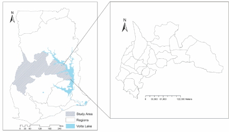
Figure 1: Map of Ghana showing the different administrative regional boundaries, including the BrongAhafo Region.
Current malaria control programs in Ghana include the distribution of insecticide-treated nets and indoor residual spraying, intermittent preventive treatment for pregnant women and prompt and effective case management. More so, the type and degree of interventions need to be based on epidemiological patterns of the disease risk. For instance, accurate maps have been recognized as important tools for optimal malaria control programs for decades [17-19]. In Ghana and for that matter the Brong Ahafo Region, the nonexistence of extensive malaria maps make it difficult to optimize scarce resources in achieving targets during control programs. Accurate maps of the geographical distribution of malaria would be a crucial tool in planning and evaluating malaria control programs. This study explores the simplicity of the application of the empirical Bayesian’s method in disease mapping. We illustrate the methodology by mapping the yearly geographical distribution of district level malaria incidences from 2008 to 2011 in the study area.
Materials and Methods
Data input
The district boundary map of the Brong Ahafo Region at a scale of 1:2500 was digitized using Arctic version 9.2. Before digitizing, the map was geo-referenced (by defining the X and Y coordinates of corner points of the map) into a UTM coordinates system. The main boundary and the 21 administrative districts within the study area were digitized as polygon features. We extracted reported malaria cases over the period 2008–2011 from the database of the Regional Disease Control Unit, B/A Region. The cases were entered as attributes of the districts. Projected population data for the years 2008-2011 obtained from the Ghana Statistical Service (GSS) were used for the computation of malaria rates.
Cumulative malaria rates were calculated for each of the 21 districts by including all cases over the period 2008–2011. We consider the observed cases Oi and populations P1 in spatial units (administrative districts) i =1,…, n , the raw rate per 100 people for each district is Mal1=(O1/ P1)×100. The population database was obtained from the records of the 2000 Population and Housing Census of Ghana [16].
Geographical patterns of malaria
A global spatial autocorrelation statistic, Moran’s Index [20], was used to assess the geographical patterns of malaria among neighboring districts in the study area. Here, the variable of interest Mal1=(O1/ P1). is a proportion with varying population densities across the observational units (i.e. districts). Therefore, we use the empirical Bayesian standardization to transform the crude incidence rate Mal into a new variable that has zero mean and unit variance; thus avoiding problems with variance instability. Following [21], the new standardized variable Malz is
where Mal is the global unconditional marginal expectation of the crude rate Mal1. Based on the method of moments approach [22],
and
An obligatory step in the calculation of Moran’s Index is to construct a spatial neighborhood matrix that contains information on the neighborhood structure of the study area. The (i, j) the element of the matrix W, denoted Wij, quantifies the spatial dependence between districts i and j, and collectively, Wij, define the neighborhood structure over the entire area.
A first order neighborhood matrix was constructed according to districts who share common boundaries. A value of one was assigned to districts which share common boundaries and/or vertex, and a value of zero otherwise. Thus, the weights.
Using the transformed variable Malz, global Moran’s Index was calculated as:
Where n is the number of spatial units or districts, Wij is the element in the spatial weights matrix corresponding to the district pairs i, j; whereas and are the transformed malaria rates for districts i and j. Since the weights are not row-standardized, the scaling factor N/S0 is applied, such that. So = Si Sj Wij
Empirical bayesian smoothing
Malaria rates were smoothed using the empirical Bayesian smoothing technique. This was to get rid of variance instability as result of heterogeneity in malaria cases and population distribution (small number problem). This smoothing technique consists of computing a weighted average between the raw rates for each district and the neighboring average, with weights proportional to the underlying population at risk [23]. In effect districts with relatively small population will tend to have their rates adjusted considerably, whereas for districts with relatively large population, the rates will barely change.
Following [23], and [24] the smoothed estimate of the risk can be expressed as
where the respective weight for each district is computed as Here and are the empirical estimates of the corresponding prior mean and variance for district i, respectively. The basic assumption is that the prior mean and variance varies across space. We use the method of moments [22] to estimate and . These are estimated as
The resulting smoothed rates were then mapped using GIS. The cutoff points for classification were based on the Jenk’s classification technique as employed in ArcGis version 9.2.
Results and Analysis
Descriptive statistics and trends of malaria
The descriptive statistics (the mean malaria rate per 100 people, the minimum rate per 100 people and maximum rate per 100 people) for the data are shown in Table 1 and Figure 2. From the Table it is clear that yearly malaria incidence rates have been on the ascendency from 28.541per 100 people in 2008 to 57.313 per 100 people in 2011. This reflects an overall incremental change of incidence rate of approximately 50% from 2008 to 2011. A scatter plot of the yearly malaria incidence against time (i.e. year), as shown in Figure 2, also reflect linear trend increment of malaria incidence every year (R² = 0.94).
![]()
    2008
    2009
    2010
    2011
    Total


    Minimum (%)
    0
    11.427
    5.360

    21.940
    38.727


    Mean (%)
    28.541
    42.741
    45.003
    57.313
    173.598


    Maximum (%)
    87.690
    98.400
    82.880
    115.956
    384.926
Table 1:  Descriptive statistics of malaria rates per 100 people for the years under
study.
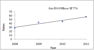
    Figure 2:  Linear trend of malaria rates per 100 people for each year from
2008 to 2009.
Geographical patterns
The Global Moran’s Index for spatial autocorrelation was used to assess the extent at which malaria incidence for neighboring districts are correlated. The Moran’s Index for spatial autocorrelation and the respective P values are also shown in Table 2. Empirically, 95% significant Moran’s Index for spatial autocorrelation was observed for all the years under study except the year 2008 (Moran’s Index = 0.1508, P value = 0.09). As a complement, a map of the Moran’s Index showing the spatial distribution of areas with high-high, lowlow, high-low, and low-high clusters are plotted Figure 4. This reflects a pattern of significant clustering of high malaria incidence in some parts of the study area and clustering of low malaria incidence in some areas in the study area.
![]()
    Year
    Moran’s I
    P value


    2008
    0.1508
    0.090


    2009
    0.4118
    0.002


    2010
    0.3102
    0.009


    2011
    0.2855
    0.015
Table 2:  Moran’s Index for spatial autocorrelation and associated significance
levels.
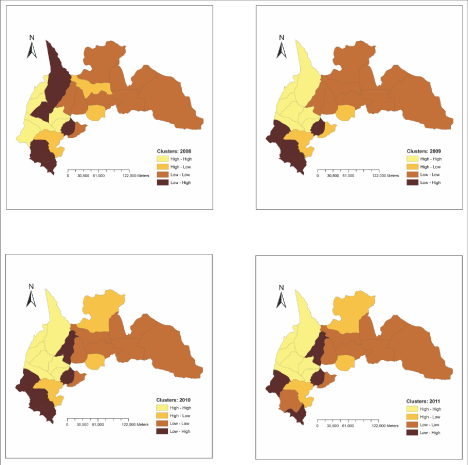
Figure 4: Moran’s I map showing areas with high-high, low-low, high-low, and low-high clusters.
The Bayesian smoothed maps of malaria showing the geographical variation of malaria for the various years under study are shown in Figure 3. A visual inspection of the Empirical Bayesian smoothed maps reflects that similar patterns of clustering of either high or low malaria incidence rates have persisted throughout the study period. Specifically, clustering of high malaria incidence rates has persisted in the western parts of the study area whiles low rates of malaria has persisted at the eastern parts of the study area.
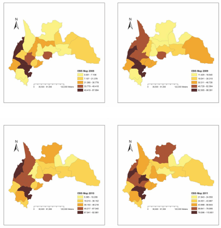
Figure 3: Empirical Bayesian smoothed map showing the geographical variation of malaria for the year 2008, 2009, 2010, and 2011.
Discussion
This study takes advantage of the capabilities of GIS and spatial analysis techniques to explore and map the geographical distribution of malaria. The methods presented and utilized are brief and simple in relation to the fully Bayesian’s approach which requires computation alyl intensive procedures like the Markov Chain Monte Carlo simulations. As such, health officials can easily understand and employ this approach to ascertain the spatial/geographical characteristics of malaria and other diseases of interest. This section presents the interpretation and implications of the results obtained.
Trends in malaria
The results of the trend analysis indicate that malaria incidences have been on the ascendency from 1997 to 2001, with an incremental change as high as 50%. Such an increment may imply/suggest that malaria control programs such as the distribution of treated nets to roll back this menace have been relatively less effective. This calls for health officials and policy makers to vary the methods applied in reducing malaria in the region. Although the government can spend scarce resources in controlling malaria, if the appropriate interventions are not applied at the disease will continue to be a major threat to public health.
Geographical patterns
The observance of positive significant Moran’s Index for spatial association for the years 2008, 2009, 2010, and 2011, indicates nonrandom distribution of malaria. Thus, the occurrences of malaria incidences during these specific years at specific geographical areas are not by chance. These patterns suggest the occurrences of similar risk factors at adjacent districts regulating the spatial dynamics of the disease. Malaria is an environmental disease, and since environmental variables are mostly correlated in space, significant spatial association is expected in the spatial patterns of the disease. This finding is useful for enhancing and optimizing malaria control programs.
Maps showing the geographical variation of malaria incidences have been created using the Empirical Bayesian smoothing method. This, though arguable, is the first attempt to create a malaria map depicting the geographical variations of malaria prevalence in the study area. Comparison of these maps (Figure 3) show that similar and particular geographical patterns of malaria have persisted over the years under study. High malaria incidence seems to have persisted in the western part of the study area whiles low malaria incidences has persisted at the eastern parts of the study area. These maps can be of great complementary resource to programs such as focused malaria control activities. For instance, programs to scale-up the coverage of Insecticide Treated Nets (ITN) as part of the strategy to reduce the burden of malaria in Ghana would see these maps as resourceful. Among several other uses, this map can also inform health officials and policy makers about geographical areas to be targeted for prompt interventions.
The significance of this study does not only lie in the usefulness of the malaria maps produced but also the simplicity of the methods applied. The study chose methods that public health officers can easily utilize with little rudimentary knowledge in mathematics and spatial analysis.
Conclusion
In this study, the empirical Bayesian smoothing method has been explored to map the geographical distribution of malaria in the Brong Ahafo region of Ghana. This method simple, not computationally intensive, and results can be easily understood by non-statisticians. The results indicate significant clustering of high malaria incidence in some parts of the study area and clustering of low malaria incidence in some areas in the study area. Specifically, clustering of high malaria incidence rates has persisted in the western parts of the study area whiles low rates of malaria has persisted at the eastern parts of the study area. The malaria risk maps developed from this study would have valuable operational use to support pragmatic malaria control programs in the study area.
References
- Elliott P and Wakefield JC: Bias and confounding in spatial epidemiology. In: Spatial Epidemiology: Methods and Applications. Edited by: Elliott P, Wakefield J, Best NG, Briggs DJ (Eds). Oxford:Oxford University Press,2000
- Elliott P, Wakefield JC, Best NG, Briggs DJ (2000): Spatial Epidemiology: Methods and Applications. In: Spatial Epidemiology: Methods and Applications. Edited by: Elliott P, Wakefield J, Best NG, Briggs DJ (Eds). Oxford:Oxford University Press,2000
- Elliott P, Wartenberg D, Spatial Epidemiology Current Approaches and Future Challenges. Environ. Health Perspectives. 2004; 112: 998-1006.
- Waller LA, Gotway CA, Applied Spatial Statistics for Public Health Data, New Jersey, John Wiley & Sons. 2004.
- Lawson AB, Disease map reconstruction Stat Med. 2001; 20: 2183-2204.
- Lawson AB. Statistical Methods in Spatial Epidemiology. John Wiley & Sons. New York. 2006.
- Lawson AB, Bohning D, Biggeri A, Lasaffre E, Viel J-F, Disease Mapping and Risk Assessment for Public Health. Edited by: Lawson A, BiggeriA,Lesaffre E, Viel J-F,Bertollini R. Chichester: John Wiley & Sons. 1999.
- Bithell JF. A classification of disease mapping methods. Stat Med. 2000; 19: 2203-2215.
- Diggle PJ. Overview of statistical methods for disease mapping and its relationship to cluster detection. In Spatial Epidemiology: Methods and Applications. Edited by: Elliot P, Wakefield JC, Best NG, Briggs DJ. Oxford: Oxford University Press. 2000.
- Lawson AB, Clark A, Spatial mixture relative risk models applied to disease mapping Stat Med. 2002; 21: 359-70.
- Goovaerts P, Int J Health Geogr, Geostatistical analysis of disease data estimation of cancer mortality risk from empirical frequencies using Poisson kriging. 2005; 4: 31.
- Pickle LW, Exploring spatio-temporal patterns of mortality using mixed effects models. Statistics in Medicine. 2000; 19: 2251-2263.
- Christensen OF, Waagepetersen R. Bayesian prediction of spatial count data using generalized linear mixed models. Biometrics. 2002; 58: 280-286.
- WHO: The world malaria report 2005. Geneva, World Health Organization. 2005.
- Snow RW, Guerra CA, Noor AM, Myint HY, Hay SI, The global distribution of clinical episodes of Plasmodium falciparum malaria, Nature. 2005; 434: 214-217.
- PHC: Population and Housing Census for 2000, Ghana statistical service. 2002.
- Kleinschmidt I, Bagayoko M, Clarke GPY, Craig M, Le Sueur D, A spatial statistical approach to malaria mapping. International Journal of Epidemiology. 2000; 29: 355-361.
- Kazembe LN, Kleinschmidt I, Holtz TH, Sharp BL. Spatial analysis and mapping of malaria risk in Malawi using point-referenced prevalence of infection data. Int J Health Geogr. 2006; 5: 41.
- Yeshiwondim AK, Gopal S, Hailemariam AT, Dengela DO, Patel HP. Spatial analysis of malaria incidence at the village level in areas with unstable transmission in Ethiopia. International Journal of Health Geographics. 2009; 8: 5.
- Cliff AC, Ord JK: Spatial Autocorrelation. London: Pion Limited. 1973.
- Assuncao R, Reis EA. A new proposal to adjust Moran’s I for population density. Statistics in Medicine. 1999; 18: 2147–2161.
- Marshall R. J, Mapping disease and mortality rates using Empirical Bayes estimators applied statistics. 1991; 40: 283–294.
- Clayton D, Kaldor J, Empirical Bayes estimates of age standardized relative risks for use in disease mapping. Biometrics 1987; 43: 671–681.
- Bailey TC, Gatrell AC: Interactive Spatial Data Analysis. John Wiley and Sons, New York, NY. 1995.