
Review Article
Austin J Earth Sci. 2014;1(1): 7.
Quantitative Well-Log Analysis of Gas Reservoirs at South Batra Field, Nile Delta, Egypt
Tharwat Abd El Hafeez1*, Hassan H El Kadi1 and El Geuoshi M2
Department Geology, Al-Azhar University, Cairo, Egypt
Department of Exploration, Mansoura Petroleum Company, Egypt
*Corresponding author: :Tharwat Abd El Hafeez, Department Geology, Al-Azhar University, Cairo, Egypt
Received: May 20, 2014; Accepted: August 25, 2014; Published: August 28, 2014
Abstract
The present research focuses on the quantitative interpretation of the well-logs of seven gas wells instead of located in the eastern part of South Batra field, Nile Delta Egypt at Latitude 31°2 & 31°9 N and Longitude 31°18& 31° 28 E. It aims to shed light on the hydrocarbon potentialities of the main Abu Madi Reservoirs (Abu Madi Level II and Abu Madi Level III). The petrophysical characteristics of the studied formations are thoroughly investigated to elucidate the hydrocarbon potentialities using (Interactive Petrophysics) software as well as a series of manual graphical and theoretical contributions. The petrophysical analysis was presented as: Litho saturation cross-plot to reflect the vertical variation of the petrophysical characteristics and, iso parametric maps to verify the lateral variation of petrophysical characteristics. The shale model shows that the dominant shale is mainly dispersed and laminated types. Distribution, which shows that the dominant shale are mainly dispersed and few laminated one. The integration of the reservoir characteristics and special core analyses of Abu Madi Formation indicate that, the most favorable places for hydrocarbon reservoirs occupy the eastern part for the Abu Madi Level II reservoir and in the middle of the southwestern part of the Abu Madi Level III reservoir in the study area.
Keywords: Interactive Petrophysics; Effective Porosity; Water Saturation and development activities
Introduction
In the last few decades gas has become the most energy source in the world. Because of the lower cost and cleanliness cost and cleanliness, the demands on it was remarkably increasing specially with the spread of frequent environmental hazards caused by the extensive use of regular energy sources. The Nile Delta seems gas prone, essentially methane, with a fair content of gas condensate [1]; few wells have produced oil and gas, it seems to still hide most of its gas potentiality [1,2]. Egypt is divided into three main petroleum provinces which are Gulf of Suez, Nile Delta and Western Desert, where the Nile Delta basin is the most prolific, prospective gas and condensate province in Egypt. The Nile Delta is the main gas producing province in the northern part of Egypt with approximately 62 TCF proven reserve [3]. The geology and the entrapment mechanism of the Nile Delta are still under discussion because the Delta does not have any outcrops of old rocks, where it is covered by the Holocene soils.
For decades there were limited drilling operations in the Nile Delta province if it compared with the other well-known producing deltas such as Niger and Mississippi deltas. The recent huge discoveries in the Nile Delta make it one of the most world known deltas. South Batra field is located northern of El Mansoura City in the Nile Delta of Egypt between latitudes 31°2` & 31°9` N and longitudes 31°18` & 31°28` E., Seven wells were selected to evaluate the reservoirs of the Miocene section (Abu Madi Formation) in the study area (Figure 1). The main objective of the present study is to achieve comprehensive evaluation of hydrocarbon reservoirs for selected wells in Abu Madi Formation at South Batra Gas Field in the study area. The quantitatively interpreted reservoir petrophysical parameters include the shale content, effective porosities, water and hydrocarbon saturations. Construction of the litho-saturation crossplots in addition to porosity and fluid saturation maps have been accomplished to clarify the vertical and lateral distribution of petrophysical parameters of the two reservoirs rock units (Abu Madi level II and Abu Madi Level III).
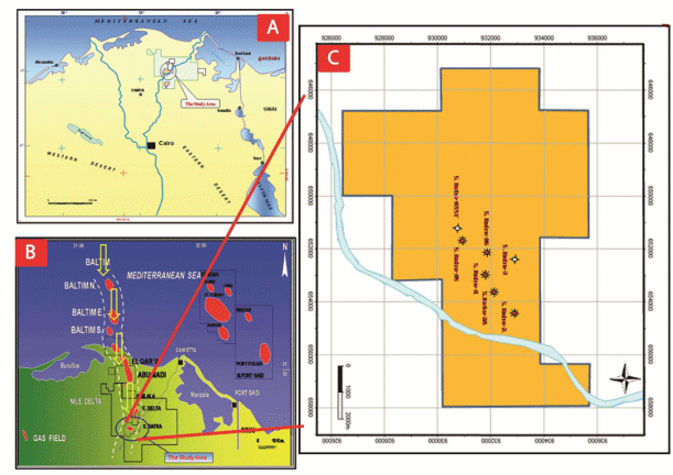
Figure 1: Location map of the study area: a) Nile Delta; b) Batra Field; & c) Well locations.
Stratigraphy
The stratigraphic sequence of South Batra Field comprises the following formations from bottom to top, Sidi Salim Formation (Langhian to Tortonian), Qawasim Formation (Tortonian-Messinian), Abu Madi Formation (Late Messinian), Kafr El Sheikh (Early to Late Pliocene), El Wastani (Late Pliocene- Early Pleistocene), Mit Ghamr (Pleistocene-Holocene) [4] (Figure 2). Abu Madi Formation consists mainly of sandstone intercalated with siltstone and shale interbeds. Based on the properties of the sandstone and the silt/mudstone facies, the Abu Madi sands could be divided into two main units (Level II & Level III). The sandstones of unit II is similar to unit III. However, it has greater regional extent as compared with the underlying basal unit III. Level–II consists of interbeds of sandstones or/and siltstones with shales streaks, the sandstones are fine to medium grained while Abu Madi shales are light grey, grey , which is reflect fluvio-marine environment. Level–III consists of interbeds of sandstones body with siltstones or/and shale streaks. Most probably, it is the thickest level in Abu Madi Formation. The sandstones are medium to coarse grained. (Abu Madi Formation sandstone is the zone of interest i.e. the most common gas/condensate bearing interval in Nile Delta region).
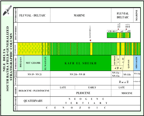
Figure 2: Lithostratigraphic Column of South Batra Field (After El Mansoura internal report, 2007).
It represents the meandering fluvial channel and is overlaid by the marine shale of the Pliocene Kafr El Sheikh Formation while Abu Madi III represents the braided streams including interchannel bars. Unit II & unit III have good porosity and permeability characteristics and are considered to be the most common gas bearing intervals in the Nile Delta Region.
The qualitative interpretation subdivided Abu Madi formation into two reservoirs. These reservoirs are correlated between wells according to their remarkable changes of log responses and similarity in the geological setting (Figure 3). Represent stratigraphic correlation profile (AA`) flatten on top Abu Madi Formation using the information inferred from available logs, especially Sonic and composite logs. This correlation shows the Abu Madi reservoirs in the studied wells (Abu Madi level II reservoir which it was pinched out to the west and Abu Madi level III reservoir which it was wide distribution through the area).
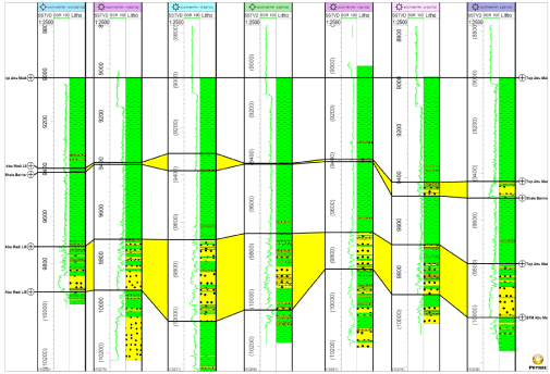
Figure 3: Stratigraphic Correlation passing through the interested wells on the study area (A-A’).
Abu Madi Formation in these Wells was subjected to formation evaluation process and complete subsurface evaluation. The Abu Madi Formation (Miocene section) is composed of Sandstones and Shale. The environmental conditions for the reservoir levels of Abu Madi Formation (Abu Madi Level II and Abu Madi Level III) are arranged in a transgressive vertical stacking pattern with a landward backstepping of the fluvial-coastal depositional systems and an overall shaling out to the north.
Structural Setting Nile Delta
The depositional history of the Nile Delta basin has been influenced by multiple tectonic events and the Mediterranean sea-level fluctuations, which have both controlled sediment supply to the basin and accumulation space [5]. Because of the Jurassic to Early Cretaceous, Tethyan rifting and the opening of Mediterranean, mixed clastic and carbonate shelf edges aggraded vertically along a steep fault-bounded shelf-slope break during the Cretaceous. The “hinge line” in Northern Egypt exerts the fundamental control on reservoir distribution in Tertiary age strata. The Tethyan rift margin was transpressionally inverted during the Syrian Arc Orogeny [6]. The “hinge line” in Northern Egypt exerts the fundamental control on reservoir distribution in Tertiary age strata. The Tethyan rift margin was transpressionally inverted during the Syrian Arc Orogeny [6].
Renewed deltaic deposition began at approximately 3.8MA [7]. The steep structural hinge line and faulted continental shelf created a large amount of accommodation space with relatively minor progradation of depositional systems (references). As a result, the primary play consists of slope-channel fairways in all levels [8]. The Plio-Pleistocene systems are the shallowest targets in the basin, which hold the majority of proven reserves [4]. The delta is divided into two sub-provinces by a faulted hinge line running WNW to ENE across the area at the latitude of the Kafr El Sheikh city (Figure 4). This hinge line is the most significant structural feature of the Nile Delta region and is known as the faulted flexure, which separates the south delta province from the north delta basin [9]. In the southern delta province, the subsurface structures are complicated by the interaction between tectonic elements of different ages and with different orientations on these structures are superimposed. These are the ENE and NE trending folds of Late Cretaceous to Eocene age (The Syrian arc folds). The Oligocene to Early Miocene NW-SE trending faults, which were associated with a major uplift in the south coupled with basaltic extrusion [9].
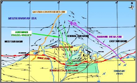
Figure 4: Sketch Map Showing the General Structural Framework of the Nile Delta Basin. (Hashem A. Hakim et al., 2010).
Structure Setting of South Batra Field
From the Oligocene to Recent, the Nile Delta has been the site of rapid accumulation of clastic sediment derived from a southward direction drainage system on the Afro-Arabian platform. The result is a 15,000 ft) thick wedge of the clastic sediments prograding northwards from the platform edge [4]. The depth structure contour maps of Abu Madi level III reservoir, noticed gentle dipping towards the north direction. There is the E-W major fault parallel to the Hinge Line, throwing down to the north which is affected on this level with some minor faults in N-S direction (Baltim trend) that throwing down to the west (Figure 5). These faults created a four way dip closures of Abu Madi level III reservoir which had a geometric shape trending E-W and NE-SW directions. The highest depths for Top Abu Madi Level III within the study area in the eastern part of the S. Batra field are occurred at the central part (in S.Batra-1, S.Batra-14 and S. Batra-24) while the lowering in the depths towards the eastern part ( in S.Batra-2 and S.Batra-24).
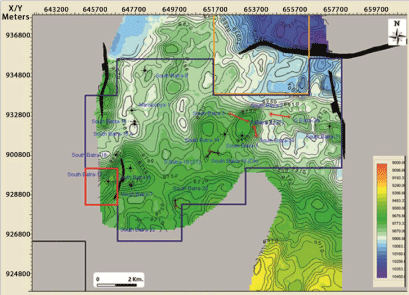
Figure 5: Depth Structure Contour Map on Top Abu Madi Level III Reservoir, Abu Madi Formation (C.I:20 ft) El Mansoura Internal Report, (2007).
While the depth structure contour maps of Top Abu Madi Level II reservoir, showed that, there is a gentle dipping toward the north and the E-W major fault still affected on Top Abu Madi Level II with some minor faults in N-S and E-W directions on the eastern side of the field. Some small closures are existed where the drilled wells are penetrated; also we note that the channel trends of Abu Madi Level II in NE-SW direction as in Level III (Figure 6).
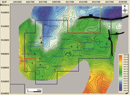
Figure 6: Depth Structure Contour Map on Top Abu Madi Level II Reservoir, Abu Madi Formation (C.I:20 ft) El Mansoura Internal Report, (2007).
From the above mentioned depth structure contour maps (Figure 5 & 6) the studied area is tectonically affected by a major deep-seated fault which is running in E-W direction, parallel to the hinge zone. This fault has affected the rock units form Oligocene to Intra Kafr El Sheikh Formation. This fault has made the northern part of South Batra area in the upthrown side of the fault, which gives a great possibility of hydrocarbon migration to this part, which is feeding the Abu Madi Reservoirs from the East Delta Field in the north, which is vertically sealed by the big thickness of Kafr El Sheikh Formation.
Data and Methods
Much well logs data is evaluated to conclude the petrophysical parameters of the studied formation of the formation evaluation system. The theory of this system is of well log analysis depend on the total used of computer through equations and formulae and pre-established charts and crossplots for the needed petrophysical parameters specially those concerning lithology , volume of shale , porosity , water saturation through the computer software.
The computer program Interactive Petrophysics (IP) has / had been applied to the studied rock units (Abu Madi LII reservoir and Abu Madi LIII reservoir), that penetrated by seven wells in the study area for determination of shale volume (Vsh) and effective porosity (∅eff).
Furthermore, the logs response to the pore’s fluid which affected greatly the log reading. Mono-Porosity cross-plots charts (Resistivity- Porosity cross-plot) are carried out to determine the formation water resistivity (Rw) which it used to determine water saturations (Sw) Lithological Identification charts (Dia-porosity crossplot) are important in formation evaluation processes. Logs can be used as indicators of lithology. The most useful logs for this purpose are Density, Neutron, Sonic, and Gamma-Ray Logs. Lithological Identification Charts use applies cross-plots between Neutron versus Density logs readings and Neutron versus Sonic logs readings to obtain the lithological characteristics.
M-N cross-plot (Tri-porosity crossplot) technique depends on the fluid and log parameters which are incorporated together essentially in the three porosity logs; Sonic, Density and Neutron. In complex lithology, the M-N crossplots are used to identify mineral mixtures.
Results and Discussion
Well logging analysis
The well logging analysis was carried on for the Abu Madi Level II and Abu Madi Level III Reservoirs in the selected seven wells in the study area. The procedure including the determination of the formation temperature and measurements of rock resistivities in the flushed and uninvaded zones, the flushed zone resistivities (Rxo) were estimated from the microspherically focused log and the uninvaded zone resistivities (Rt) were calculated from the available deep resistivity logs. The determination of the Shale content (Vsh) of Abu Madi Level II and Abu Madi Level III reservoirs were calculated from the combination of density and neutron logs using the Double Clay Indicators work and the using of GR clay indicator using the linear method; the minimum clay volume of the correlated clay volume of the two methods were selected by using of the Interactive Petrophysics software [10].
The determination of effective porosity (Φ) was also executed in both clean and shaly rock units by the combination of the density and the neutron logs measurement by using a mathematical equation of Poupan and Gaymard [11].
ΦNd = (ΦN + Φd) / 2 In clean formations
Φeff = (ΦNc + Φdc) / 2 In shaly formations
During our work, the Rw was determined and applied in our study for both interested reservoirs nearly the same equal 0.13 ohmm, which was calculated by the using of graphical solution (Pickett Plot), resistivity-porosity computations cross plot [12] is constructed between the true resistivity of uninvaded zone (RT) and the effective porosity deduced from any porosity tools (ΦN, pb or both) by applying the electrical rock parameters which it was extracted from the special core analysis of Abu Madi Level III n=1.82, m=1.79 & a=1, while the Abu Madi LII we used the theoretical rock parameters n=2, m=2 & a=1.
The lithology is achieved through the construction of lithological identification crossplots (neutron, density and sonic combination crossplots) to specifically determine the reservoir lithology [13]. Tri-porosity (M-N) crossplots are used to generally determine the lithology of Abu Madi Level II and III of Abu Madi Formation in the studied area (Figure 7 & 8), which showed that the main lithology type is sandstone intercalated with shale. M and N are defined by Burke et al. [14].
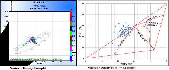
Figure 7: S. Batra -2 (Abu Madi LII) Lithological Identification.
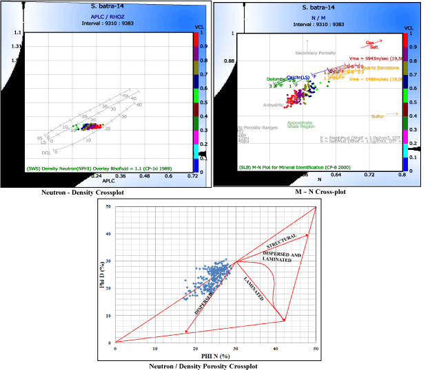
Figure 8: S. Batra -14 (Abu Madi LIII) Lithological Identification.
Moreover, the type of shale was determined by choosing the shale model, which reflects the dominant shale types that are of dispersed and few laminated one.
The determination and discrimination of the fluid contents as water, movable and residual hydrocarbons were also carried out for both reservoirs (Abu Madi LII & Abu Madi LIII) using Indonesian equation Schlumberger [13].
Corresponding well-log data have been processed through a sequence of graphical relations and also by the available computer software (Interactive Petrophysics) to evaluate quantitatively the different petrophysical characteristics. Computer processed procedures integrated with the available conventional and special core analyses were used in this paper to extract the petrophysical model (Effective Porosity cutoff (Φeff) = 10%, Clay volume cutoff (VCL) =58%, Water Saturation cutoff (SW) =65%) to obtain the main petrophysical characteristics (Heff, Vsh, ∅eff and Sh) of the predicted hydrocarbon reservoirs.
Hydrocarbon potentialities
The output results of the petrophysical characteristics are illustrated vertically (in the form of litho-saturation crossplots) and horizontally (in the form of iso-parametric maps). Seven litho-saturation crossplots are constructed, for example the litho-saturation crossplot of Abu Madi Level II S. Batra-2 well (Figure 9), and the litho-saturation crossplot of Abu Madi level III S. Batra-14 well (Figure 10). The lateral variation of the petrophysical characteristics are illustrated in the form of iso-parametric maps, which show the effective thickness (Heff), effective porosity(Φeff), shale content (Vsh), water saturation (Sw), and hydrocarbon saturation (Sh) distribution through the studied area, in Abu Madi Formation, level II and III (Figure. 11 & 12).
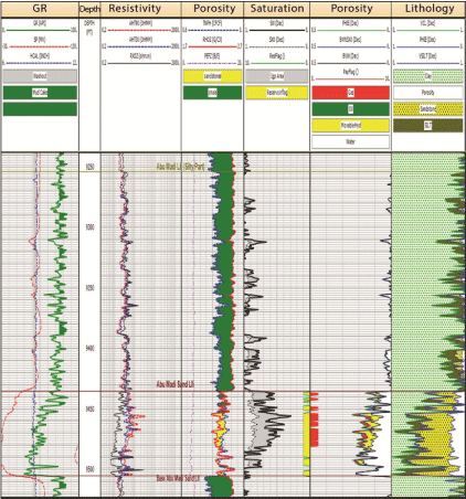
Figure 9: Litho-Saturation Cross-plots for Abu Madi LII in S.Batra-2 well.

Figure 10: Litho-Saturation Cross-plots for Abu Madi LIII in S.Batra-14 well.

Figure 11: Combined Petrophysical Parameters Distribution maps for Abu Madi LII Reservoir.

Figure 12: Combined Petrophysical Parameters Distribution maps for Abu Madi LIII Reservoir.
The effective thickness distribution map for Abu Madi Formation, Abu Madi Level II reservoir shows the variation in effective thickness values from minimum value in the west of the study area at S. Batra-14, S. Batra-19 and S. Batra-19 ST. wells where the channel reservoir pinched out to shale and the maximum value is in the north eastern part of the study area at S. Batra-2 well (56 ft.) This map shows that the effective thickness increases from the west towards the east of the study area, While in Abu Madi Level III reservoir, it increases towards the northeastern and northwestern part (from 65ft to 157ft) at S. Batra-2 and S. Batra-3 and it decreases in thickness towards south east at S. Batra-24 well and towards south west at S. Batra-19 ST well.
The shale content (Vsh) of Abu Madi Level II reservoir increases towards the southwestern part of the area under investigation (from 23% to 100%), while in Abu Madi Level III reservoir, it increases towards the northwestern part (from 24% to 38%).
The effective porosity (∅eff) of Abu Madi Level II reservoir generally increases towards the east and northeastern directions of area under investigation (from 18% to 20%) at S. Batra-2 well, while for Abu Madi Level III reservoir increases towards the northeastern part of the study area (from 15% to 19%).
The water saturation (SW) of the Abu Madi Level II reservoir shows increases towards the western part of the study area at S. Batra-14, S. Batra-19 and S. Batra-19ST. wells and it decreases towards the east at S. Batra-2 well, while for the Abu Madi Level III reservoir the water saturation generally increases towards the north west direction of the study area at S. Batra-3 well and it decreases towards the south western part at well S. Batra-14 well.
The hydrocarbon saturation (Sh) of Abu Madi Level II reservoir shows increases towards the eastern part of the study area (from 18 % to 46%), while for Abu Madi level III reservoir generally increases towards the southern part and especially in the closure at the south western part of the area under investigation (from 40% to 50 %).
One of the most important applications from the petrophysical evaluations is the determination of hydrocarbon water contact (i.e. GWC). An initial gas-water contact (G.W.C) for Abu Madi Level II reservoir was assigned at 9481 ft Sub Sea, which it was identified from the Well log analysis of S. Batra-2 well. While the other studied wells in the same level varied from dry hole to Gas down to at 9476 ft Sub Sea at S. Batra-24 well. While the other level Abu Madi Level III, have not a definite gas water contact from the petrophysical evaluation of the studied wells. The differences in the gas water contact may be related to different compartment (structural or stratigraphic effect) (Figure 13,14 & 15).

Figure 13: Combined Litho-Saturation Cross-plots for Abu Madi LII Reservoir.

Figure 14: Combined Litho-Saturation Cross-plots for Abu Madi LIII Reservoir.

Figure 15: Combined Litho-Saturation Cross-plots for Abu Madi LII and Abu Madi LIII Reservoirs Through the Studied Wells.
Conclusion
This study aims at making a full subsurface and petrophysical evaluation of the eastern part of South Batra Field, In the Nile Delta of Egypt. This study is a trail to gain a full overview of the stratigraphic and structural setting in the study area , In addition to the petrophyical characteristics of the rock units of interest (Level II and III in Abu Madi Formation) , to evaluate the hydrocarbon potentialities of the studied area . The output results of the petrophysical characteristics of Abu Madi Formation are as follows:
The effective thickness of Abu Madi Level II increases in the east of the study area, while the effective thickness of Abu Madi Level III increases in the northeastern and northwestern parts.
The effective porosity of Abu Madi Level II increases in the east and northeastern parts of the study area, while the effective porosity of Abu Madi Level III northeastern part.
The shale content of Abu Madi Level II increases in the southwestern part of the study area. While the shale content of Abu Madi Level III increases in the northwestern part.
The hydrocarbon saturation of Abu Madi Level II increases in the eastern part of the study area, while the hydrocarbon saturation of Abu Madi Level III increases in the southern part, especially in the southwestern part.
From the previously mentioned results, the petrophysical characteristics of Abu Madi level II and Abu Madi level III reservoirs reflect the ability to store and produce hydrocarbon. It is recommended to drilling more wells into / for the eastern part of the study area, for more hydrocarbon production form Abu Madi Level II.
It also recommended to drilling more wells into / for the central part of the southwestern part of the study area, In the vicinity of South Batra-14 well, for more hydrocarbon production from Abu Madi Level III, for more favourable economic conditions. It also recommended to avoiding drilling into/for the areas of high concentrations of water saturation.
Acknowledgement
We would like to thank the Egyptian General Petroleum Corporation (EGPC) for providing the well log data for South Batra Field Also, special thanks to the Geophysics Laboratory, Geology Department, Faculty of Science, Al-Azhar University Corporation for knowledge extended on Interactive Petrophysic (IP) software usage.
References
- Said Keshta, Farouk J, Metwalli, Al Arabi HS. Analysis of Petroleum System for Exploration and Risk Reduction in Abu Madi/Elqar'a Gas Field, Nile Delta, Egypt. International Journal of Geophysics. 2012; 2012.
- Sarhan M, Barsoum K, Berello F, Talaat M, Nobili M. The Pliocene play in the Mediterranean offshore-structural setting and growth fault controlled hydrocarbon accumulations in the Nile delta basin. A comparison with the Niger delta basin, PETRBEL and IEOC, Cairo, Egypt and AGIP S.P.A, san donato, Milanese, Italy. 1997; 2-6.
- Niazi M, Dahi M. UN Explored Giant Sandstone Features in Ultra – deep water, West Mediterranean, Egypt, E.G.P.C, Egypt. 2010.
- El Mansoura Internal Report. Seismic Sequence Stratigraphic and Facies Architecture of Miocene Reservoirs in South Batra Field. 2007; 8, 84 & 87(Unpublished Internal Report).
- Hashem A., Raafat R., Gabr M., Bunt R. and Mckeen R. "Petroleum Systems Analysis of South East El Mansoura Area and Its Implication for Hydrocarbon Exploration, Onshore Nile Delta, Egypt.” Mediterranean Oil Conference (MOC). 2010.
- Ayyad MH, Darwish M. “Syrian Arc Structures: unifying model of inverted basins and hydrocarbon occurrences.” 13th E.G.P.C. Petrol. Conf., Cairo. 1996; 40-59.
- Dalla S, Harby A, Serazzi M. Hydrocarbon exploration in a complex incised valley fill: An example from the late Messinian Abu Madi Formation Nile Delta Basin, Egypt. 1997.
- Dalla S, Harby A, Serazzi M. Hydrocarbon exploration in a complex incised valley fill: An example from the late Messinian Abu Madi Formation Nile Delta Basin, Egypt. 1997.
- EGPC. Nile Delta and North Sinai Fields, discoveries and Hydrocarbon potentials. Cairo, Egypt. 1994.
- Synergy. Interactive petrophysics software Version 3.6. 2009.
- Poupon A, Gaymard R. The evaluation of clay content from logs. SPWLA 11th Ann. Log. Symp. 1970; 18-25.
- Pickett GR. A review of current techniques for determination of water saturation from logs. Jour. Pet tech. 1966.
- Schlumberger. The Essentials of Log interpretation Practice, Copyright, France. 1972; 14: 154-155.
- Burke JA, Campbell RL, Schmidt AW. The Litho-Porosity Crossplots-A method of Determination of Log Data; SPWLA, 10th. Ann. Log Symp. 1969; 233-235.