
Research Article
Austin J Earth Sci. 2015;2(1): 1010.
Hydrometeorological Study of the Himalayan Region
Nandargi S* and Dhar ON
Indian Institute of Tropical Meteorology, India
*Corresponding author: : Shobha Nandargi, Centre for Climate Change Research, Indian Institute of Tropical Meteorology, Pashan, Pune, India
Received: February 11, 2015; Accepted: April 07, 2015; Published: April 08, 2015
Abstract
The Himalayan mountain ranges uniquely placed to modulate the regional monsoon climate in the Indian subcontinent. Many studies over the last 30 years focused on investigating the large-scale modes of variability of the Indian monsoon climate with respect to the role of the Himalayan ranges and the Tibetan Plateau. On seasonal and inter-annual time-scales, the monsoon season in the Himalayas provides a stage where rapid environmental change and extreme events (viz. rainstorms, floods, landslides, etc.) occur on schedule. In view of this, the present study deals with the hydrometeorological studies of the three major sections of the Himalayas i.e. a) Northwest b) Central and c) Northeast Himalayas with special reference to 24-hr highest rainfall, rainstorms and floods occurred during the last 135 years or so besides mentioning meteorological situations responsible for causing such extreme events during monsoon as well as non-monsoon season.
Keywords: Himalayas; Variation of rainfall; Extreme one-day rainfall; Climate change
Introduction
While writing about the Himalayas one is reminded of the famous lines from Frank S. Sympthe that legendary mountaineer and writer, who wrote in his book "Kamet Conquered" as follows :-
"The Himalayas must be approached humbly. Respect their beauty, their majesty and their power and they will treat you as you deserve. Approach them ignorantly or in a spirit of bravado and they will destroy you. Other mountains forgive mistakes but not the Himalayas!!"
The Himalayan mountain ranges exercise a very dominant influence on the climate of the Indian subcontinent and the Tibetan plateau extending from Nanga Parbat (8126m) in the northwest to Namche Barwa (7756m) in the east, in the form of a convex arc with its convexity to the south (Figure 1). As a result of its southerly dip, it is nearer to the equator by about 700kms in its eastern end. The total length of this mountain range is about 2400kms and its width varies from about 250 to 400kms. This loftiest mountain complex contains eleven of the fourteen world's peaks exceeding 8000m (Figure 1) and 31 peaks exceeding 7600m in elevation. There are series of narrow chains of high mountains with their crest-lines (falling between 5000m to 5500m) are transverse by a number of trans-Himalayan rivers and their tributaries which play an active role in eroding and shaping the high mountains, producing deep valleys and gorges. Physically the entire range is divided into three almost parallel subranges.
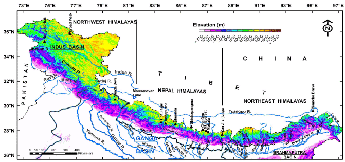
Figure 1: Digital Elevation Map of the Himalayas showing 3 main sections, Elevation and River systems.
Outer Himalayan ranges (or the Shivalik hills or foot-hills of the Himalayas): separate the Himalayas from the Indo-Gangetic plains to the south. Average height: ~900m to 1200m, width- between 1000m to 5000m.
Middle Himalayan ranges (also called as the Pir Panjal in NW India and Mahabharat range in Nepal): These are a series of broken mountain ranges. Mean elevation ranges between 3700m to 4500m a.s.l. and width of about 5000m.
The great Himalayan range: is the innermost line of the highest ranges of perpetual snow and ice. Average height varies from 6000m to 8800m a.s.l., which separates the Tibetan Plateau from the Indian sub-continent. The highest peaks are located in this range.
Himalayan Meteorology and its dominant role in controlling the weather and climate of the Indian sub-continent has been described by several workers in recent years [1-5]. The Himalayas are responsible for the formation of a heat low over Sind (Pakistan) and its neighbourhood and the seasonal monsoon trough over the Indo-Gangetic plains during the summer monsoon months from June to September [1,5]. The rugged topography enhances heavy to very heavy rainfall in the rivers originating in the Himalayas causing serious floods and destruction to human lives in the plains.
The role of the Himalayas and the Tibetan Plateau to its north for the generation and maintenance of the Asian summer monsoon was demonstrated by the numerical model studies [6] mentioning that if the 'Himalayas' is removed from its present position, Asian countries will have no weather like 'southwest monsoon'. The Third Assessment Report of the Intergovernmental Panel on Climate Change [7] also pointed out the critical role of the Himalayas in the provision of water to continental monsoon Asia and clearly revealed its vulnerability to climate change in terms of hydrology and water resources.
In view of the above, an attempt has been made to study the hydro-climatic features of the Himalayan region in the Indian subcontinent dividing the entire Himalayan region into three suitable regions - a) Northwest (NW) (India), b) Central (Nepal) and c) Northeast (NE) (India, Bhutan).
Data Used
In the present study, daily rainfall data of 267 stations (Figure 2) homogeneously distributed in the NE Himalayan region of India and Bhutan are considered. It may be noted that in the extreme northern part of Bhutan, Kameng river basin in Arunachal Pradesh and extreme northeastern part of Luhit and Debang basins in India, still there are practically no precipitation measuring stations.
In the NW Himalayas, daily rainfall data of more than 200 stations, whose elevations vary from 300 to 4100 m a.s.l, and the data from the adjoining plains numbering about 350 stations, were used for the period 1875 to 2010.
The rainfall and flood data for these two regions were collected from the following sources:
- Various publications of India Meteorological Department (IMD) viz. Monthly, Seasonal and Annual Reports, Daily rainfall summary, Weekly Rainfall Report, etc. and the data from National Climate Data Centre (NCDC), IMD, Pune.
- Rainfall records from the Project Authorities such as National Thermal Power Corporation (NTPC), National Hydro-electric Power Corporation (NHPC), Central Water Commission (CWC), New Delhi.
- Rainfall volumes at Indian Institute of Tropical Meteorology (IITM), Pune since 1871.
- The Rainfall Registration Authorities and Forest Departments of Punjab, Haryana, Himachal Pradesh, Uttarakhand (formerly Uttaranchal) and J&K states.
- Bhutan Meteorological Centre (1989-2005).
- Relevant flood data of Indian rivers were collected mainly from Central Water Commission (CWC), New Delhi for the period 1986-2010.
Flood data
In Central or Nepal Himalayas, before 1947, there was only one meteorological observatory in the Indian Embassy complex at Katmandu (1324m) the capital of Nepal. In connection with the Kosi High Dam Project and Flood Control Projects of the Govt. of India, more than 100 meteorological stations were started by IMD throughout the Nepal with the permission of the Nepal Govt. From early sixties Nepal Meteorological Service (NMS) augmented this network by adding more stations and at present there are about 270 meteorological stations (Figure 2) whose data are available for varying periods, from 10 to 50 years or so. Using these data, International Centre for Integrated Mountain Development (ICIMOD) [8], Katmandu, Nepal, prepared generalized maps of precipitation distribution over the entire Nepal region [9]. Data of higher elevation stations are sparse and fragmentary to arrive at any firm conclusions and hence are not considered.
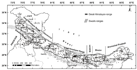
Figure 2: Map of the Himalayan region showing different sections and present network of rainfall stations.
Methodology
Using the above mentioned rainfall data, mean monthly, seasonal and annual rainfall, highest 24-hr rainfall and heavy rainspells occurred over the three sections of the Himalayas have been worked out. The analysis of heavy rainspells (or severe rainstorms) is of prime importance for planning and design of water resources projects. Moreover in the absence of actual records of stream flow data, they are useful for assessing flood potentialities as well as the yields of individual river catchments. A rainstorm is defined as a spatial distribution of rainfall yielding average depths of precipitation, which equals or exceeds a specified threshold value over a river basin in association with any meteorological phenomena. By knowing depths of rain which falls during different durations of time and over specific areas, runoff and river flow can be estimated from the rainstorm analysis.
Estimations of maximum average rain depths from analysis of severe rainstorms over a basin are normally made by the following methods considering the orography, nature and size of the basin/ catchment, the data period and its suitability- a) Depth-Duration (DD) Method, b) Depth-Area-Duration (DAD) Method and c) Storm Transposition (ST) Technique. The main objective of all these methods is to estimate the maximum possible rain depths, which a basin may experience in future. All the above methods are well documented in various publications [10-15]. Severe rainstorms considered in this study broadly satisfy the criteria used by the authors in their several studies on severe rainstorms of India [16-20].
GIS technique is used in rainfall and storm analysis, to measure raindepths for areas and to produce spatial distribution of rainfall and rainstorm maps.
A flood is generally defined as a relatively high stage of a river at a given gauge/discharge (G/D) site. It has been defined by various people in different ways but in India, a river is said to be in flood when it crosses the Danger Level (DL) at a given G/D site on a river. The DLs at each G/D sites are fixed by State Engineers in consultation with CWC Engineers.
Meteorological situations responsible for causing heavy rainfall over different sections of the Hima
Besides the orography, the meteorological situations which are mainly responsible for causing heavy rainfall over the Himalayan region are as follows:
Cyclonic disturbances and low pressure systems: originate in the Bay of Bengal during the monsoon season. When they travel over the central parts of the Indian region, some of them recurve in a northerly to northeasterly direction [18] (Figure 3). This is mostly due to the synchronization of movement of strong westerlies (Western Disturbances) over the extreme northwest to northeast Himalayas with the passage of monsoon disturbances in the lower latitudes cause heavy to very heavy rainfall along the foothills of the Nepal and NE Himalayas.
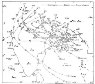
Figure 3: Recurving Cyclonic disturbances which cause heavy rainfall to the foot-hills of the Himalayas.
Normally, the southwest monsoon starts withdrawing from the northwest and adjoining regions of India from 15 September, it gets revived again in association with a Bay of Bengal / Arabian Sea depressions which move towards NW region and interacting with western disturbances cause exceptionally heavy rainfall especially in J&K, sub- Himalayan regions of Himachal Pradesh, Punjab and Uttarakhand Himalayas.
The periodic movement of Western Disturbances (WD) that originate from extra-tropics in the Mediterranean and Caspian seas and travel through extreme north Indian region give rainfall/snowfall and chilly weather conditions. On an average 5-7 WD move over the northwestern region of India during the winter months [1]. An equal number of induced lows form to their south and move east and northeastward give heavy to very heavy rains over the plains of Punjab, Haryana, and Uttar Pradesh. Similarly, upper air troughs in the westerlies over extreme north of Arunachal Pradesh, cause heavy rainfall over the NE region.
Shifting of the axis of the monsoon trough to the foot-hills of the Himalayas from north Indian plains (known as 'break monsoon situation'), cause very heavy rainfall in the eastern and central Himalayas. Break situations mostly occur during the monsoon months of July and August and occasionally in September and caused very heavy rainfall on about 65% of occasions causing serious flooding in the rivers of these regions [21]. This particular meteorological situation in combination with orography of the Himalayas and occasionally with the passage of WD along the Himalayas is responsible for causing copious amounts of rainfall in the Himalayan catchments while the plains in the downstream reaches of these river basins receive practically no rainfall.
Apart from the above, the following factors also play an important role in augmenting rainfall and thereby floods in the river basins of the Himalayas:
- Indiscriminate destruction of forest and vegetal cover in the upper reaches of a river,
- Deposition of silt washed down from bare and poorly covered hill slopes in the upper reaches of a river,
- Man-made obstructions to the free flow of rivers like bridges, embankments, etc.,
- Improper agricultural practices like shifting cultivation etc. and
- Failure of dams and artificial lakes created by advancing glacier tongues or landslides.
Effect of altitude on precipitation climatology of the Himalayas
The Climate of Himalayas is said to be of Alpine nature, e.g. the altitude in the Central or Nepal Himalayas varies from 60m in the south at Terai (Foothills of the Himalayas) to 8848m at Mt. Everest in the north within a short distance of 90km to 120km which cause variation in climate. It gets colder as the elevation increases and gets warmer and wetter as the elevation decreases. As a result, the climate in general changes in the different Himalayan sections rather quickly which may lead to sudden occurrences of cloud bursts, high winds, snowstorms, etc, resulting in quick floods, which makes the climate over the region quite unpredictable and at times dangerous too. The Himalayan ranges from some sort of a barrier for the southwest monsoon (hereafter called as 'monsoon') winds from crossing over to Tibet, thereby causing heavy to very heavy rainfall in the foothills and the adjoining plains of India to its south [22-23]. Studies [24-26] carried out on variation of rainfall with height in Nepal Himalayas showed that rainfall is maximum near the outer Himalayas, i.e. foothills and a second maximum of rainfall is obtained near about the middle Himalayas at a height of about 2400m asl Thereafter, rainfall decreases sharply as one proceeds northwards to higher elevations till the Great Himalayan Range is reached (Figure 4).
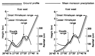
Figure 4: A schematic representation of the mean monsoon precipitation across the Kosi Himalayas in Nepal.
At meso-scale, the rainfall is highly influenced by local orography. Precipitation in general increases from low land valleys to higher mountain slopes up to certain heights. The windward slope gets more precipitation than the leeward side. It is also showed [27] using the precipitation data of seven stations in southern Tibet, that there is a reduction of 25% to 30% in precipitation in southern Tibet side compared to windward side of Nepal Himalayas.
Ladakh, region which is situated on the lee side of the western part of the Himalayas, monsoon activity in this region is very weak, e.g. the mean annual precipitation of Leh station is hardly 93 mm which is less than one-fourth of what is received in Lhasa, the capital of Tibet [28]. Whereas stations located in the Pir Panjal ranges receive far greater rainfall, because these stations lie to the windward side of monsoon disturbances and the Pir Panjal range traps most of the moisture from the monsoon currents, on account of orographic lifting. However, these monsoon currents get denuded of their moisture by the time they cross the 3000 to 4000 m high Pir Panjal range and stations located to the lee side of the range receive very less rainfall [29].
Met. Sub-divisions of India in the eastern Himalayas receive the highest normal annual and monsoon rainfall and as one move along the Himalayan ranges from east to west, the rainfall decreases sharply [30]. In the interior of the Himalayas, monsoon rainfall is much less compared to the plain areas and in the first few frontal ranges of the Himalayas. In addition to this, heavy rainfall does not occur in a continuous spell as seen over the plain foothill Himalayan regions but there can be sudden falls of heavy rain within a short duration of 3-4 hours to a long duration of 10-14 hours.
In the Himalayan region, snow generally accumulates in the winter months (October to March) and sometimes during summer months (April to May). The snow that always remains throughout the year is considered as permanent snow. To delineate the snowfed and rainfed catchment areas over any Himalayan river basin with reference to permanent snowline, requires extensive analysis and use of satellite data representing the status in non- monsoon period probably during Feb.-Mar. and during monsoon period from Jul. to Sept. and hence it requires a separate study [31]. However an EL 4000m (Figure 5) may approximately be considered as the permanent snowline over the Himalayan region as per the suggestion from experts/Research Scientists who have vast experience about the Himalayan region.
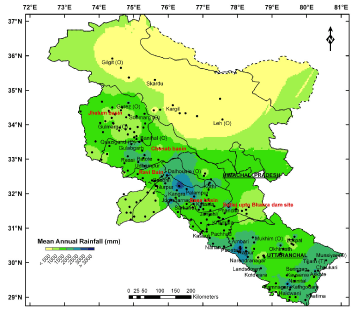
Figure 5: Spatial distribution of mean annual rainfall over the NW Himalayas.
Considering the altitudinal aspect, a good number of studies [32-35,22,24,36,21,37-39] have been carried out on different aspects of Himalayan climatology and rainfall distribution due to heavy rainspells. These studies emphasized that such studies are very important for planning, design and operation of water resources and hydro-electric power projects in the region.
In the following three sections rainfall characteristics and associated flood disasters over the three major sections of the Himalayas have been described.
Northwest (NW) Himalayas (India)
The NW Himalayan region considered in the present study extends over most of the hill states of the northwestern Indian region viz. J&K, Himachal Pradesh, Himalayan parts of Punjab-Haryana comprising of the Indus river basin (India) and Uttarakhand state (India) (Figures 1&2). The Indus river system in India consists of the main river Indus and its major tributaries, the Jhelum, the Chenab, the Ravi, the Beas and the Sutlej from the east. The entire Indus basin lying in Tibet (China), India, Pakistan and Afghanistan extends over an area of about 1154,500 sq. km. The present study is restricted to the drainage area (about 321,290 sq. km) lying in India which is nearly 9.8% of the total geographical area of the India. The upper part of the basin lying in J&K and Himachal Pradesh is mostly mountainous and criss-crossed by narrow valleys.
The northern side of the western Himalayas, also known as the 'trans-Himalayan belt', is a region of barren, arid, frigid, and windblown wastelands. Similarly, the upper Indus catchment which falls in the Ladakh region is located in the worst arid region of India due to lack of precipitation. However, the climate to the south is typically monsoonal lasting for just two months or so (mid July to September). The upper portion of the region receives good rainfall during the winter season due to the passage of WD (Section 4). As such, bulk of precipitation occurs during the winter season in Kashmir valley especially in Jhelum river catchment, Ladakh region, Himachal Pradesh and Uttarakhand. Any heavy rainfall for duration of 1 to 2 days can cause serious floods over the region.
The mean annual rainfall over the entire NW Himalayas (Table 1 and Figure 6) broadly range from about 193 mm (14%) for the Indus basin in the extreme north to 1602 mm (63%) for the Beas basin to south. The maximum annual rainfall of 3097mm was recorded at Dharamsala (Lower) (Himachala Pradesh) and least at Khalatse (50mm) (Ladakh). Uttarakhand and Himachal Pradesh sub-division experience about 66% to 67% whereas J&K sub-division receives only 43% of annual rainfall during the monsoon season [30].
    Months/Seasons
    Mean Rainfall mm for the catchments


    Sutlej *
    Beas
    Ravi & Chenab
    Jhelum
    Indus #


    January
    90.9
    79.8
    104.8
    91.4
    21.2


    February
    82.4
    81.9
    119.5
    109.4
    21.2


    March
    86.6
    91.8
    129.9
    139.5
    36.7


    April
    53.9
    59.4
    97.2
    122.5
    26.1


    May
    64.6
    56.3
    60.8
    91.1
    21.0


    June
    104.1
    119.0
    76.0
    60.5
    8.5


    July
    262.6
    421.1
    267.9
    91.9
    12.2


    August
    234.2
    415.7
    276.3
    92.3
    14.5


    September
    124.6
    180.0
    124.0
    57.1
    10.6


    October
    37.8
    42.6
    34.3
    40.8
    6.0


    November
    15.3
    15.6
    21.0
    27.1
    4.2


    December
    42.6
    38.8
    59.5
    51.9
    11.1


    Winter Dec.-Mar.
    302.5
    292.3
    413.7
    392.2
    90.2


    Spring/Summer Apr.-Jun.
    222.5
    234.7
    233.9
    274.1
    55.6


    SW Monsoon Jul.-Sept.
    621.4
    1016.8
    668.2
    184.2
    26.7


    Autumn Oct.-Nov.
    53.1
    58.2
    55.3
    120.0
    20.8


    Annual
    1199.5
    1601.9
    1371.1
    975.6
    193.4


    SW monsoon as % of Annual
    52
    63
    49
    19
    14


    Note: Sutlej*: Sutlej basin upto Bhakra dam site    and Indus#: Indus basin upto Indian border
Table 1: Mean monthly, seasonal and annual rainfall mm for Individual catchments in the NW Himalayas.
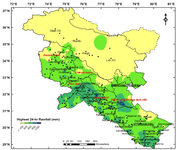
Figure 6: Spatial distribution of highest 24-hr rainfall over the NW Himalayas.
Rainfall recorded at individual stations showed that Badrinath (Uttarakhand) experienced monsoon rainfall of about 94% whereas Leh and Gilgit experienced 40% and 10% respectively. Maximum number of stations (49) recorded highest 24-hr rainfall in the month of July followed by August (40), September (35), December (16) and January (12). Table 2 gives the list of stations recording highest 24-hr rainfall >400mm and spatial distribution is shown in Figure 7.
    Station Name
    Highest 24-hr rainfall mm
    Date of Occurrence


    Kilba
    609.6
    27.12.1958


    Sangla
    558.8
    21.12.1958


    Arki
    416.6
    12.08.1963


    Barauli
    418.6
    21.08.1901


    Nahan
    561.3
    14.08.1910


    Dharamsala
    530.0
    25.07.1967


    Jogindarnagar
    600.0
    14.08.1996


    Kataula
    413.0
    08.07.1957


    Batala
    474.5
    05.10.1955


    Malikpur
    410.0
    26.09.1988


    Dalhousie O
    409.0
    09.09.1966


    Qazigund O
    432.3
    23.08.1905


    Kaladhungi
    413.0
    10.07.1970


    Haldwani
    413.0
    11.07.1970


    Askote
    404.2
    28.07.1968


    KharsaliO
    400.0
    15.09.1963


    Dehradun O
    487.0
    25.07.1966


    Mussoorie O
    440.0
    19.08.1890


    Khadrala
    762.0
    28.01.1968
Table 2: Highest 24-hr rainfall mm >400 mm recording stations in NW Himalayas.
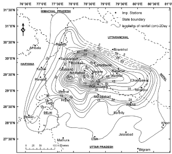
Figure 7: 2-day isohyetal pattern of 17-18 Sept. 1880 rainstorm over Uttarakhand and neighbourhood.
As a part of CWC Project, on the basis of 1901 to 2005 rainfall data, severe rainstorms were analyzed by DD method over the five individual catchments of the Indus basin (India) [40] and their estimated results of Standard Project Storm (SPS) and Probable Maximum Precipitation (PMP) raindepths are given in Table 3. Considering the physiographic features of the Indus catchment in the extreme north and due to lack of sufficient precipitation data for available stations, it's not correct to carry out any rainstorm analysis over this region to derive the PMP design raindepths. However, by considering precipitation data of stations for relatively longer period (>50 years), point PMP estimated by Hershfield [41-42] statistical method are given in Table 4 for rough use.
    Name of the catchment
    SPS raindepths mm for
    PMP raindpeths mm


    1-day
    2-day
    3-day
    1-day
    2-day
    3-day


    1
    Sutlej upto
    102
    140
    172
    122
    168
    191


    Bhakra dam
    24/9/1988
    24-25/9/1988
    10-12/7/1993


    site
    MMF: 1.20 24-26/9/1988
    1.11 10-12/7/1993


    2
    Beas
    192
    328
    358
    250
    420
    458


    5/10/1955
    4-5/10/1955
    3-5/10/1955


    MMF: 1.28 3-5/10/1955


    3
    Ravi
    169
    323
    333
    216
    413
    426


    5/10/1955
    4-5/10/1955
    3-5/10/1955


    MMF: 1.28 3-5/10/1955


    4
    Chenab
    95
    187
    246
    114
    224
    295


    24/9/1988
    24-25/9/1988
    24-26/9/1988


    MMF: 1.20 24-26/9/1988


    5
    Jhelum
    83
    131
    170
    106
    168
    218


    1/9/1928
    1-2/9/1928
    31/8-2/9/1928


    MMF: 1.28 31/8 - 2/9/1928
Table 3: SPS and PMP raindepths over different catchments of the Indus basin.
      No.

      Station
    PMP mm

      Estimates of maximum rainfall mm for Return period of


    Point
    1000-yr
    5000-yr


    1-day
    2-day
    3-day
    1-day
    2-day
    3-day
    1-day
    2-day
    3-day


    1.
    Leh
    69
    73
    91
    52
    68
    75
    62
    81
    89


    2.
    Skardu O
    97
    122
    143
    78
    117
    127
    92
    139
    150


    3.
    Kargil
    169
    216
    256
    145
    214
    245
    172
    257
    294


    4.
    Dras
    176
    270
    344
    159
    279
    343
    189
    332
    410


    5.
    Gilgit
    108
    125
    156
    85
    120
    137
    101
    143
    163
Table 4: Estimates of point PMP and return periods at selected stations in the upper Indus basin in India up to Pakistan boundary.
Analysis of daily rainfall data of about 200 stations from 1875 to 2010 [43], showed that there are five most severe rainstorms which occurred over and near this region in the past. If the entire period is divided into 25-year sub-periods it is seen that each sub-period has recorded one severe rainstorm (Table 5) except during the present period of 2001 to 2010. DAD analysis of these rainstorms showed that these severe rainstorms occurred over more than 100,000 sq.km of area. However, their DAD raindepths for standard areas up to 50,000sq.kms are given in Table 6 for comparison. Table 6 shows that 17-18 Sept., 1880 rainstorm (Figure 8) occurred over and near the plains of Uttarakhand state is definitely much severe for 1 and 2-day durations than all the other 3-day duration rainstorms, whereas Sept., 1988 rainstorm (Figure 9) occurred over the entire Indus basin covering more than 2 lakhs sq.km area caused serious floods in the major river basins.
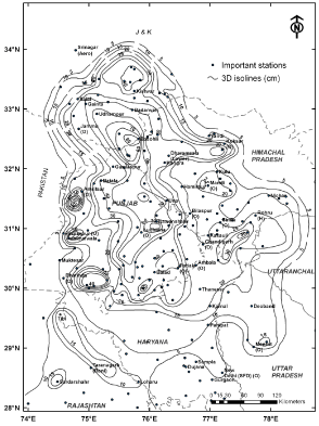
Figure 8: 3-day Isoyhyetal pattern of 24-26 Sept. 1988 rainstorm over the NW Himalayas.
    Period
    1875-1900
    1901-1925
    1926-1950
    1951-1975
    1976-2000


    Severe Rainstorm
    17-18
      Sept. 1880
    28-30
      Sept. 1924
    26-27
      Sept. 1947
    3-5
      Oct. 1955
    24-26
      Sept. 1988
Table 5: Distribution of most severe rainstorms during 1875 to 2010.
    Rainstorm
    Storm Centre


    Area in hundreds of sq.km


    District
    Point
    1
    5
    10
    20
    50
    100
    200
    500


    24/9/1988
    Nawanshahr
    51.4
    51.0
    49.0
    46.9
    43.4
    37.0
    31.8
    27.6
    20.6


    Jullundur


    24-25/9/1988
    Nawanshahr
    64.9
    63.3
    59.5
    56.2
    52.0
    45.3
    42.8
    38.8
    31.5


    Jullundur


    24-26/9/1988
    Basohli
    81.1
    80.9
    79.7
    78.0
    74.7
    66.2
    62.0
    54.1
    41.5


    Kathua


    5/10/1955
    Aliwal
    49.5
    48.0
    45.7
    45.0
    43.8
    40.5
    35.5
    28.9
    19.9


    Ambala


    4-5/10/1955
    Batala
    69.1
    67.7
    65.5
    63.5
    61.2
    55.7
    51.0
    43.8
    32.5


    Gurdaspur


    3-5/10/1955
    Batala
    82.6
    81.0
    75.3
    69.7
    63.9
    58.4
    53.4
    47.2
    38.4


    Gurdaspur


    26/9/1947
    Dadupur
    30.5
    29.9
    28.6
    27.3
    26.0
    23.5
    20.8
    17.7
    14.9


    Ambala


    26-27/9/1947
    Dadupur
    40.6
    40.4
    39.1
    38.4
    37.1
    34.2
    30.8
    25.8
    21.0


    Ambala


    25-27/9/1947
    Dadupur
    56.3
    55.3
    51.0
    48.4
    45.8
    42.4
    38.2
    32.6
    26.8


    Ambala


    29/9/1924
    Lansdowne
    35.1
    34.9
    33.8
    32.9
    31.0
    27.1
    25.0
    23.0
    18.5


    Garhwal Himalayas


    28-29/9/1924
    Lansdowne
    59.4
    58.2
    57.1
    56.0
    54.0
    49.5
    44.5
    38.8
    33.8


    Garhwal Himalayas


    28-30/9/1924
    Lansdowne
    77.5
    76.8
    75.5
    74.0
    70.9
    63.5
    55.8
    49.0
    41.0


    Garhwal Himalayas


    18/9/1880
    Nagina
    82.3
    82.0
    80.0
    77.5
    73.6
    62.8
    51.5
    40.5
    26.3


    Bijnor


    17-18/9/1880
    Nagina
    104.1
    103.5
    100.0
    99.1
    95.9
    86.8
    76.8
    63.0
    41.4


    Bijnor
Table 6: Average raindepths cm for 1, 2 and 3-day durations of most severe rainstorms.
The severe rainstorms that occur over this region normally lead to peak floods in the Yamuna River. All time record floods occurred in Aug. 1976, Sept. 1978 and Sept. 1988 [32,44,45,39]. During Sept. 1988 flood; the Yamuna River crossed the DL at 204.83m at Delhi Rly. Bridge and touched the maximum level of 206.92m on 27 Sept.1988 [39].
Usually, the western Himalayan region experiences the cloud burst events (Table 7) during the monsoon season in association with the strong monsoon circulation or the interaction of monsoon circulation with the mid-latitude westerly systems. The orography of the region plays a dominant role by increasing the convection and hence the intensity of cloudburst causing heavy landslides, flash floods and loss of human lives.
    Date of occurrence of cloudburst
    Regions affected


    15 Aug. 1997
    Simla district, Himachal Pradesh


    17 Aug. 1998
    Kumaun division of Uttarakhand


    16 Jul. 2003
    Kullu, Himachal Pradesh


    6 Jul. 2004
    Alaknanda river in Chamoli district, Uttarakhand


    16 Aug. 2007
    Himachal Pradesh


    7 Aug. 2009
    Munsiyari, Pithorgarh district. of Uttarakhand


    6 Aug. 2010
    Leh, Ladakh region of J&K


    15 Sept. 2010
    Almora district of Uttarakhand


    9 Jun. 2011
    Near Jammu


    20 Jul. 2011
    Upper Manali region, Himachal    Pradesh


    4 Aug. 2012
    Chamoli district of Uttarakhand
Table 7: Recent events of cloudbursts in the NW Himalayas
However Laddakh region of J&K is not known to be frequently affected by this type of phenomena. It is a cold desert and average rainfall for the month of August is 14.5mm only. The highest rainfall ever recorded over Leh during 24 hours has been 51.3mm (22 Aug.1933). A series of cloudbursts have been reported near Leh in J&K around 0130-0200 hours IST on 6th Aug., 2010 leading to flash flood and mud slides over the region causing huge loss of lives and properties [46].
Central or Nepal Himalayas
The Central or Nepal Himalayas extends along the Himalayan ranges for 885km and its width from north to south varies from 145km to 248km (Figure 1). The Himalayan altitude varies in the Nepal from 60m asl at Jhapa, the easternmost district in the south to more than 8848m asl at Mt. Everest in the north. The rugged topography is mainly responsible for producing different climates ranging from sub-tropical in the south to Alpine type in the north of the Nepal Himalayas. Therefore, entire Nepal has been divided into the five broad regions (Figure 9) from south to north with increasing altitudes [47,48]. Most of the rainfall stations (i.e.50) are located in the 100 to 200 m altitudinal range and 30 stations in the range of 1300- 1400 m.
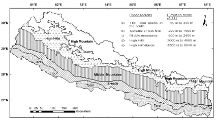
Figure 9: Broad topographic regions of Nepal and their elevations.
Although rainfall data of Nepal are not readily available for a long period of years, studies [25,49,50,27,51,26,53,54] carried out for different sections of Nepal Himalayas showed that monsoon (June to September) is the main rainy season of this region during which 80% of the annual rainfall is received. The annual precipitation received in Everest-Kanchenjunga region (altitude 3000m to 4000m) in Nepal is barely 1000mm [50]. According to IMD's study [55] the Khumbu glacier (5000m to 6000m) at the foot of the Everest peak on the Nepal side receives precipitation of about 450mm.
Towards the north, as one approach nearer the Great Himalayan Range, precipitation decreases and is of the order of 1000mm to 2000mm in the eastern half and in western half it is 1000mm to 1500mm or even <500mm excluding the southeastern and middle region which receive rainfall in the range of 1500mm to 2500mm. However, pockets of heavy precipitation (>3500mm) are located in the middle part of the Nepal (Figure 10) on the windward (southern) side of the Great Himalayan range:
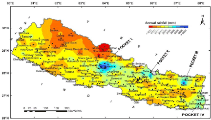
Figure 10: Spatial distribution of mean Annual rainfall mm over Nepal Central Himalayas.
- Pocket I: It is located in the south of 7km high Annapurna range in central Nepal about 40 to 50km south of the range in the upper Pokhara valley. This is the heaviest pocket of rainfall within the Central Himalayas [49,51,26] (Figure 10) as far as present records are concerned. In the valley, good number of stations, viz. Pokhara (827m), Lumle (1740m), Bhadaure Deurali (1600m) Lamachaur (1070m), Khudi Bazar (823m), etc. recorded >4000 mm of annual rainfall.
- Pocket II: It is located to the south of Langtang Himalayan range which is just northeast of Kathmandu valley (1324m) and almost quite close to the Kodari pass which connects central Nepal with Tibet (Figure 10) receiving monsoon and annual rainfall >4000mm. A couple of stations viz. Chautara (1660m), Gumthang (2000 m), Sarmathang (2625m) have recorded annual rainfall of the order of 4000 mm. The 7km high Langtang Himalayan range, acts as a barrier to the moist winds from the south, thereby causing them to shed most of their moisture before crossing the range [26].
- Pocket III: This pocket lies south of the high Himalayan range connecting Kanchenjunga (8598m) and Everest (8848m) peaks. Stations in this pocket like Num (1676m) and Chepuwa (2591m) have recorded rainfall in the range of 2500mm to 4200mm. The rainfall distribution around the two highest peaks, viz. Mt. Everest and Kanchenjunga [50] showed that the Kanchenjunga region receives greater rainfall than the Everest region. As one approach these two peaks from the south, rainfall decreases rapidly because moisture is shed on the Himalayan ranges to the south. Chepuwa station which lies midway between these two regions, south of the Great Himalayan range recorded mean annual rainfall of 2750mm. There is a reduction of about 25% to 30% in the rainfall on the southern Tibetan side i.e. lee side of the Mt. Everest and Kanchenjunga region due to the rain shadow effect of the Great Himalayan range [27].
- Pocket IV: In the southeast of Nepal, in the Illam district, Kanyam tea estate recorded mean annual rainfall >3000mm. This station which is located just close to the boundary of Nepal with the Darjeeling district of India, receives fist burst of monsoon when monsoon sets in over Nepal.
The above high rainfall pockets are located in such regions of the Himalayas where large topographic differences occur over very short distances. This promotes rapid ascent and condensation of moist air which results in yielding high amounts of rainfall.
The lowest rainfall is received in the trans-Himalayan regions of Mustang and Manang regions which are located in the Central and adjoining northwest Nepal. The mean annual rainfall of these semiarid regions varies from 200mm to 800mm. The aridity of the regions is mainly due to these being on the lee side of 7km high, 40 to 50km long Annapurna range in the Central Nepal [51].
Extreme rainfall events in different parts of the Nepal showed that highest 24-hr rainfall is predominant in the plains of Tarai and Siwalik regions than at higher altitudes (Figure 11). 7 stations recorded highest 24-hr rainfall >450mm (Table 8) and 23 stations >400mm during the period 1947 to 2005 of which Musikot and Gumthang stations recorded >500 mm in 24-hrs. About 70% of the stations recorded their highest 24-hr rainfall in the range of 100mm to 300mm. In the year 2002, which was a drought year for India; due to break monsoon situation, Nepal received very heavy rainfall during the monsoon months. About 13 stations recorded highest 24- hr rainfall during this year.
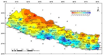
Figure 11: Spatial distribution of highest 24-hr rainfall over the Nepal.
    Station
    District
    High. 24-hr rainfall mm
    Date of Occurrence


    Parasi
    Nawalparasi
    495.0
    03/08/1998


    Musikot
    Gulmi
    503.0
    29/07/1960


    Hetaunda N.F.I.
    Makwanpur
    456.8
    31/07/2003


    Tistung *
    Makwanpur
    540.0
    20/07/1993


    Gumthang
    Sindhupalchok
    505.0
    25/08/1968


    Hariharpur Gadhi
    Sindhuli
    482.5
    20/07/1993


    Anarmani Birta
    Jhapa
    473.0
    10/10/1959


    * Village Development Committee
Table 8: Highest 24-hr rainfall mm > 450 mm recording stations in Nepal Himalayas (1947 to 2005).
Nepal has three major river systems (Figure 12) viz. a) The Karnali or Ghagra, b) The Narayani or Gandak, c) The Kosi or Sapta Kosi, each having numerous tributaries flow south towards the Terai plains and joins the mighty Ganga River in the Indo-Gangetic states of Uttar Pradesh and Bihar in north India. All these rivers have their head waters in the high Himalayan glaciers and snow fields and during the monsoon months are normally in high floods due to heavy rainfall in their respective catchments.
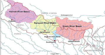
Figure 12: Location of three major river basins of Nepal Himalayas.
Heavy rainstorms occur frequently in the middle mountains and lower plains of Nepal causing landslides, debris flows and floods, destroying lives and property. The heaviest rainspells recorded are: 15-19 Jul. 1978, 15-17 Jul. 1983, 15-17 Sept. 1984, 11-13 Aug. 1987 and 20 Oct. 1987, 26-27 Aug. 1990, 19-22 Jul. 1993, 12-13 Aug. 1995, 10-11 Aug. 1997, 3-4 Jul., 1999, 23-24 Jun. 2000, 21-26 Jul., 2002, 30- 31 Jul. 2003, 10 Jul. 2004, 24-25 Sept. 2005, 16-23 Jul. 2007, 4-16 Oct. 2009, 5-7 May 2012. Considering the topography, it is not proper to analyse these heavy rainspells using the standard techniques of rainstorms analysis [15]. Therefore, an attempt has been made here to study heavy rainspells and associated floods over different parts of the Nepal Himalayas.
Floods in Nepal result from heavy rainfall, snowmelt, glacier lake outburst, landslide dam outburst, or a combination of two or more of them [56] e.g. heavy rainspells of 27-30 Sept. 1981, in 1902/03, 19-22 Jul. 1993 over Bagmati, 28 Sept-7 Oct. 1968 over east Rapti. Floods of 1964, 1981 and 1984 in the Sunkosi River are some events in the eastern region. Similar studies on floods occurred in different parts of the Nepal and damage caused during 1968 to 2000 [57,58,8,59-61] and a brief history of floods in Kathmandu Valley for the period of 1988 to 2002 [62] high lightened the severity of rainfall and floods in these regions.
In the recent past, heavy rainspells of 21-26 Jul., 2002, 30-31 Jul. 2003, 26 Jul. 2004 caused record rainfall in the Bagmati catchment affecting eastern and mid region of the Kathmandu valley [63]. The heavy rainspell of 4-16 Oct. 2009 affected 14 districts in the mid and far west regions of Nepal. Latest heavy rainspell of 5-7 May 2012 over the Pokhara valley resulted in blockage of Seti River due to landslide and accumulated water caused flash flood around Mt. Annapurna and neighbourhood. This shows that natural disasters associated with extreme weather events are widely distributed in Nepal and show an increasing trend [63].
Northeast (NE) Himalayas (India, Bhutan)
Northeast Himalayan region comprises of the major portions of Sikkim, Sub-Himalayan West Bengal, and Arunachal Pradesh, Assam in the Indian sub-continent and Bhutan forming the major Brahmaputra river system. The Brahmaputra river originates at an elevation of about 5300m in the Kanglung Kang glacier in western Tibet adjoining the Kailash range and known by the name of Yarlong- Tsangpo and flows for about 1625km eastwards almost parallel to the Great Himalayan range on its northern side. In eastern Tibet, the river flows around the snow-capped massif of Namche Burwa (7,756m) and the Gyala Peri and enters into Arunachal Pradesh at Kepang La above Tuting station as river Siang (also called Dihang) (Figure 13).
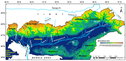
Figure 13: Physiographic map of NE Himalayas showing Brahmaputra river system.
Two more Himalayan tributaries, Dibang and Lohit join the Siang River in Sadiya sub- division of Tinsukhia district and it is from this confluence that the river takes the mighty form and is called as 'Brahmaputra' (Figure 14). This region of the eastern Himalayas in Arunachal Pradesh receives heavy rainfall generating 70% flow of the Brahmaputra River during the SW monsoon months of mid-May to mid-October, resulting in tremendous death and destruction. After flowing through the Assam Valley up to the Goalpara town, river takes a southern curse and enters Bangladesh. In the extreme west of the NE Himalayas, the Teesta (or Tista) river originates in the glaciers of the Sikkim Himalayas and joins the Brahmaputra River in Bangladesh.
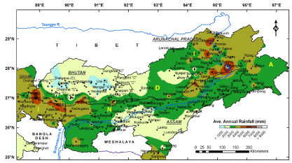
Figure 14: Average annual rainfall mm distribution over the NE Himalayan region.
Next to Sikkim, Bhutan is situated in the NE Himalayas and it stretches over 340 km in length from west to east and 170km from north to south with an approx. area 38394 sq.km. The terrain is mostly rugged and mountainous with elevations ranging from 200m to >7000m asl (Figure 15) within a distance of less than 175 km. About 21% of the total land, above 4,200m asl is covered by the snow, glaciers and glacial lakes. The variation of the climate is extremely dependent on the altitude. The Manas is the largest river system of Bhutan, acts as a trans-boundary river in the Himalayan foothills between southern Bhutan and India.
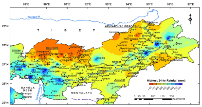
Figure 15: Spatial distribution of highest 24-hr rainfall mm over the NE Himalayan region.
      Stations
    NE Himalayan region
    24-hr highest rainfall mm
    Date of Occurrence


    Mathabhanga H
    Sub-Himalayan West Bengal
    800.6
    13.08.1990


    Darjeeling O
    "
    504.4
    31.07.1995


    Kurseong
    "
    640.0
    05.10.1968


    Mongpoo
    "
    546.1
    12.06.1950


    Buxa
    "
    538.5
    08.06.1921


    Hasimara H
    "
    790.6
    21.07.1993


    Kumargram H
    "
    657.5
    21.07.1993


    Nagarkata H
    "
    805.3
    06.08.1990


    Neora H
    "
    802.4
    26.05.1990


    Malda O
    "
    567.5
    28.09.1995


    Raiganj H
    "
    680.0
    11.07.1999


    Gedu "C"
    Bhutan
    520.0
    03.08.2000


    Surey "C"
    "
    611.6
    02.08.2000


    Ananda
    Northeast India
    600.0
    20.08.1979


    Bomdila
    "
    570.2
    11.06.1976


    NorthLakh
    "
    508.0
    22.09.1956


    Passighat A
    "
    912.4
    28.07.1911


    Roing
    "
    745.0
    16.08.1977


    Zero
    "
    800.0
    16.09.1987


    Goalpara
    "
    712.1
    08.06.1970


    Jamduar
    "
    805.5
    07.09.1976
Table 10: Highest 24-hr rainfall mm > 500 mm recording stations in NE Himalayas.
Besides monsoonal rainfall during June to September, there is considerable thunderstorm activity in May in NE Himalayan region and the rainfall caused by these thunderstorms (about 33.8 cm, [64,65] is comparable in magnitude to the rainfall of any of the monsoon months. Therefore, in the present study monsoon period is considered from May to October for this region.
The catchment of Brahmaputra and its tributaries in India receive very heavy rainfall ranging from 1100mm to 6400mm a year [66]. Most of the run-off in the river is contributed by heavy rainfall of about 5100 to 6400mm in the Abor and Mishmi hills in Arunachal Pradesh and 2500 to 5100mm by the Brahmaputra basin. The basin in India receives a mean annual rainfall of 2300mm and its catchment in northeast (i.e. Arunachal Pradesh) receives 4100mm of rainfall/year [67,68]. Rainfall in the NE Himalayan sector amounts to 5000mm/year with lower ranges receiving more than the higher ranges (6350mm or more) [67,68] causing frequent flood ravages in the Assam Valley, e.g., Dibrugarh (a station at the head of the Assam Valley) in the eastern part receives annual rainfall of the order of 2850mm whereas Pasighat, located at foot hills of the eastern Himalayas in Arunachal Pradesh receives 5070 mm of annual rainfall. Tuting station located further high up in the Himalayas (Siang basin) receives rainfall of about 2740mm annually [67,68].
The mean annual rainfall of 267 stations (India) (1901 to 2005) is of the order of 2444.3mm. The spatial distribution of annual rainfall over the NE Himalayas (Figure 16) shows that zone of the highest rainfall is located just near the foot hills of the Himalayas. Rainfall decreases sharply with the increase in elevation towards the higher ranges of the Himalayas northwards. 5 stations viz. Buxa, Pasighat and Denning (India) and Sipsoo and Tendu (Bhutan) recorded >5000mm of average annual rainfall. 17 stations recorded more than 4000mm of annual rainfall. The mean annual and seasonal rainfall for the 6 major river basins in NE Himalayas (Figure 17) is given in Table 9. Due to the altitude of some individual stations in this region also, there are pockets of high and low rainfall around these stations. Pasighat (AP) (India) and Sipsoo (Bhutan) recorded the highest mean annual rainfall of 8972mm and 5866mm [69] respectively. Average annual precipitation of Bhutan is 1679mm and 70% of it occurs in monsoon months [69]. The central and northern parts of Bhutan receive relatively less rainfall.
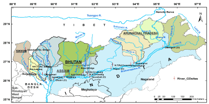
Figure 16: Major river basins of the NE Himalayas showing G/D sites on the rivers in India.
      No.
    Major river basins
    Catch. Area Sq.km
    Average Rainfall mm
    Season rainfall as % of annual


    Jun.-Sept.
    May- Oct.
    Annual
    Jun.- Sept.
    May- Oct.


    1
    Entire Siang basin
    14039
    1725.0
    2395.0
    3024.0
    57
    79


    2
    Subansiri
    24116
    1164.0
    1450.0
    1844.0
    63
    79


    3
    Puthimari and Pagladiya
    3380
    1629.8
    2088.2
    2434.4
    67
    86


    4
    Manas Bhutan
    18300
    938.2
    1144.0
    1349.8
    70
    85


    Manas India
    23050
    1799.9
    2331.1
    2637.9
    68
    88


    Manas Entire
    41350
    1070.7
    1326.6
    1548.0
    69
    86


    5
    Torsa, Raidak, Sankosh
    21810
    1815.5
    2206.4
    2461.2
    74
    90


    6
    Teesta India
    10155
    2323.6
    2747.4
    3009.2
    77
    91
Table 9: Mean annual and seasonal rainfall mm of the major river basins in NE Himalayas
The highest 24-hr rainfall recorded by the stations range from 36mm at Gyetsha (C), Bhutan to 912.4mm at Pasighat in Arunachal Pradesh, India. 71 stations recorded highest rain amount during the rainy season of July, 37 stations each in June and August and 25 stations in the September month. Most of the stations recorded highest 24-hr rainfall of the magnitude 200mm to 300mm (Figure 15). There are pockets of highest 24-hr rainfall, located mostly in the extreme northeast and western region of the NE Himalayas. In the northern part of the Bhutan there are less number of stations and have recorded highest 24-hr rainfall <50 mm. 21 stations (Table 10) recorded highest 24-hr rainfall >500mm. These stations lie close to the foot hills of the Himalayas to the windward side.
The entire NE Himalayan region consists of six major river systems (Figure 17) which are the sub-basins of the main Brahmaputra river system. These river systems have their origin in the glaciers at high altitude Himalayas. Each one has numerous tributaries which drain the Himalayan mountain slopes from north to south and mostly from the 'V' shape drainage structure. Flowing to the south they join the Brahmaputra River in India and Bangladesh. All these rivers during the monsoon months of June to September are in high floods due to heavy rainfall in their respective catchments.
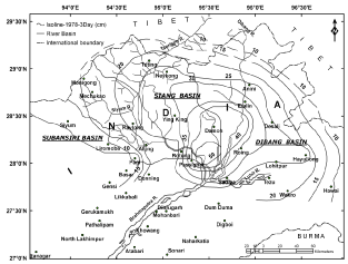
Figure 17: 3-day 21-23 Jun isohyetal pattern of 1978 rainstorm over the Siang basin.
In the past 9-12 Aug., 1902 and 18-21 Jun.,1934 are the most severe rainstorms occurred over this region [64]. Both these rainstorms were caused by the northward shifting of the eastern end of the monsoon trough (i.e. 'Break'). The average raindepths caused by these two rainstorms over 67,700sq.km of an area for 4-day duration were 300 mm and 280 mm respectively with the Mawsynram as the centre of the rainstorm. 1-day extreme point rainfall (or PMP) using Hershifeld's statistical technique [42] over the Assam Valley varied from 300 to 750mm [70]. By using the same technique, but using a longer and more up-to- date network of stations data, the IITM, Pune [71] found the extreme point rainfall varying between 400 to 800 mm.
The rainstorm analysis [72,73] over NE Himalayas revealed that 21-23 Jun.,1978 rainstorm (Figure 18) over the entire Siang basin and 12-14 Jul.,1985 over the Subansiri basin have yielded highest raindepths by DD method for 1, 2 and 3-day durations and these are referred to as SPS raindepths. These SPS raindepths were then moisture maximized with a suitable Moisture Maximization Factor (MMF) to obtain PMP raindepths (Table 11). Similarly, using long period daily rainfall data, severe rainstorms were selected for DAD analysis. Of all the severe rainstorms, 24-26 Jun., 1931 rainstorm (Figure 19) produced highest raindepths for 1, 2 and 3-day durations over and near these two basins. As the region is highly mountainous, rainstorm transposition has not been carried out. But by applying suitable elevation correction (EC) factor to envelope DAD raindepths, SPS raindepths were obtained. PMP was evaluated by applying appropriate MMF to SPS raindepths (Table 11).
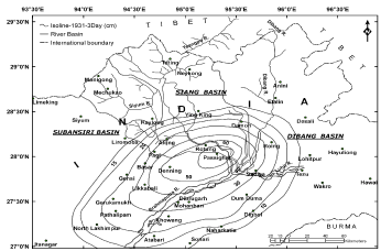
Figure 18: 3-day 24-26 Jun. isohyetal pattern of 1931 rainstorm.
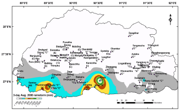
Figure 19: 3-day spatial distribution of 2-4 Aug. 2000 rainstorm over Bhutan.
    Design rain depths mm for
    Siang basin
    Subansiri basin


    1-day
    2-day
    3-day
    1-day
    2-day
    3-day


    SPS by DD method
    100
    180
    233
    67
    119
    135


    PMP by DD method
    122
    220
    284
    80
    143
    162


    Rainstorm considered
    21-23 June,1978 MMF = 1.22
    12-14 Jul. 1985 MMF = 1.20


    SPS by DAD method
    133
    220
    273
    83
    155
    198


    PMP by DAD method
    179
    297
    369
    112
    209
    267


    Rainstorm considered
    24-26 June,1931 rainstorm MMF = 1.35 IMD, 1988


    PMP by Statistical method    Point PMP
    287
    396
    545
    179
    246
    369


    Note:    Depth-Duration DD method Depth-Area-Duration DAD method
Table 11: Comparison of SPS and PMP estimates obtained by different methods over Siang and Subansiri basins.
Using Hershfield statistical technique [41,42] estimates of PMP for all stations in and around the two basins were made based on available rainfall data for 1 to 3-day durations (Table 11). However, it may be mentioned here that estimation of any statistical parameter should be based upon long period data series, i.e. > 30 years. Since the length of rainfall records for stations in the Subansiri and Siang basins are rather short, the above PMP estimates may be considered as the tentative and are subjective to change as and when more rainfall data becomes available in the study region.
Manas basin, which is a trans-boundary catchment of Bhutan and Assam (India) has experienced 6 to 7 rainstorms in the recent past, of which 11-13 Jul., 1996, 5-7 Jul., 1998, 18- 20 Oct., 1999 and 2-4 Aug., 2000 rainstorms were found to be the most severe one and their average raindepths are given in Table 12 for 1, 2 and 3-day durations. The 3-day spatial distribution of 2-4 Aug. 2000 rainstorms is shown in Figure 20. The most noteworthy heavy rain spells experienced over the sub-Himalayan West Bengal-Sikkim section are 11-13 June 1950 and 3-5 October 1968 (Figure 20) [74].
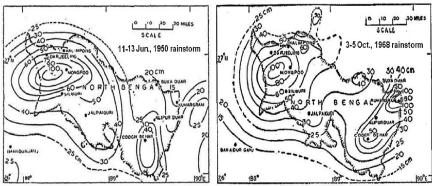
Figure 20: 3-day isohyetal cm map of 1950 and 1968 rainstorm over northern region of sub-Himalayan West Bengal.
    Rainstorm
    Average Raindepths mm for


    1-day
    2-day
    3-day


    11-13 Jul. 1996
    50.9 13/7
      Pema Gatshel "C"
    93.5 12-13/7
      Pema Gatshel "C"
    112.2
      Pema Gatshel "C"


    5-7 Jul. 1998
    44.7 7/7
      Dungmain "C"
    76.1 6-7/7
      Dungmain "C"
    101.8
      Dungmain "C"


    18-20 Oct. 1999
    42.2 19/10
      Yebilaptsa
    73.8 19-20/10
      Chendebji 'C"
    96.1
      Chendebji 'C"


    2-4 Aug. 2000
    59.7 3/8
      Surey "C"
    118.3 2-3/8
      Surey "C"
    159.8
      Surey "C"


    Note: Figs. in brackets indicate the date of    occurrence and centre of the rainstorm
Table 12: Average raindepths mm for severe rainstorm for Manas basin in Bhutan.
By considering the orography of the region, Depth-Duration (DD) analysis is the most suitable technique applicable for rainfall analysis of the region. SPS raindepths obtained from the DD analysis and PMP derived from maximization of SPS values would have been the most appropriate ones to use for any hydrology purposes.
Flood studies [35,75,70,24,76,77,79,23,78,80-87] over the Brahmaputra basin showed that frequency of floods are quite high in the rivers of northeast India. The highest flood deviation recorded by different (G/D) sites at these rivers (Table 13) during the period of 1986 to 2010 showed that rivers, Jiabareilly, Manas and Teesta recorded highest flood deviation more than 10.0m during the last 25 years.
      River

      Gauge/ Discharge Site
    Danger Level m
    Highest Deviation m
    Date of Occurrence


    a
    Main Brahmaputra river :


    1
    Brahmaputra
    Dibrugarh
    104.24
    2.24
    03/09/1998


    Nematighat
    85.04
    2.33
    11/07/1991


    Tezpur
    65.23
    1.36
    27/08/1988


    Guwahati
    49.68
    2.55
    08/08/2000


    Goalpara
    36.27
    1.16
    31/08/1954


    Dhubri
    28.62
    1.74
    28/08/1988


    b
    Northern tributaries of the Brahmaputra river :


    2
    Subansiri
    Badatighat
    82.53
    4.31
    28/06/1972


    3
    Jaibareilly
    N.T.Rd. Crossing
    77.00
    12.22
    22/09/2010


    4
    Puthimari
    N.H.Crossing
    51.81
    4.65
    20/06/1993


    5
    Pagladiya
    N.T.Rd.Crossing
    52.75
    2.72
    08/07/2004


    6
    Manas
    N.H.Crossing
    47.56
    11.03
    13/07/1984


    7
    Beki
    N.H.Crossing
    45.10
    1.10
    04/08/2000


    Road Bridge
    44.38
    1.78
    04/08/2000


    c
    Rivers joining    the Brahmaputra in Bangla Desh :


    8
    Raidak
    Tufanganj
    35.30
    1.06
    21/07/1993


    9
    Torsa
    Ghugumari Cooch Behar
    40.41
    1.05
    03/08/2000


    10
    Jaldhaka
    Nagarkata
    185.60
    7.75
    1954


    11
    Teesta
    Anderson Bridge
    210.50
    18.10
    04/10/1968


    Coronation Bridge
    149.40
    10.65
    10/1968
Table 13: Highest flood deviations recorded at G/D sites on the Brahmaputra and its tributaries 1986-2010.
Although Bhutan does not have comprehensive precipitation data, on the available data it was observed that the eastern and southern foothill regions of Bhutan, which have intensively dissected terrains with deeply eroded, steep and closely spaced gullies, gorges and river valleys, often experience floods caused by heavy rainfall. A noteworthy flash flood of 2004 affected six eastern Dzongkhags, of which Trashigang, Trashiyangtse and Samdrup Jongkhar were the most affected areas with damages to property and livestock.
Conclusion
At present, the enormous water resources of the Ganga and Brahmaputra river are not fully utilized and practically most of its flood waters is running waste into the Bay of Bengal through Bangladesh after causing enormous damage by way of ravaging floods in north and northeast India, Nepal and Bangladesh. Though there is not much scope for increasing irrigation facilities in the Assam valley beyond a certain limit due to lack of proper storage sites especially in the main Brahmaputra river and some of its tributaries, but there is enormous potential for hydropower generation in this region especially at the "Great Bend" of the Dihang river when it enters India from Tibet and in some of its tributaries. The Brahmaputra Board in their Report on Dihang Project [88] stated that most of the hydropower potential of India is concentrated in the Brahmaputra basin, out of which, more than 80% lies in the Siang and the Subansiri river basins. A realistic assessment of this vast water resource is most essential to plan optimum utilization of water available in these basins.
Similar is the case with the Kosi, the Gandak and the Karnali basin in Nepal. All this has to be tapped fully for the proper development in the coming years. This, of course, can be done with the full cooperation between India, Nepal, Bhutan and Bangladesh so far as the developments of water resources projects of this region are concerned.
Acknowledgement
Authors are thankful to Director, IITM, Pune for his keen interest and encouragement for carrying out this study. Authors express their sincere thanks to all the Himalayan Project Authorities, Forest Departments, Central Water Commission, N. Delhi and India Met. Department (IMD) for supplying the relevant rainfall and flood data.
References
- Rao YP. The Climate of the Indian sub-continent. In: Climate of southern and western Asia. Takahasti K and Arukawa H, editors. World Survey of Climatology, Elsevier, Amsterdam. 1981; 9: 67-182.
- Mani A. The Climate of the Himalayas. In: The Himalayas Aspects of Change. Lall JS, Moddie AD, editors. Oxford Univ Press. 1981; 3-15.
- Das PK. The Climate of the Himalayas. In: Singh TV, Kaur J, editors. Himalayan Mountain and man, Studies in the eco-development. Print House, Lucknow. 1983.
- Pant GB, Rupa Kumar K. Climate of south Asia. In: John Wiley and Sons Publ, Chishester, UK. 1997; 4: 320.
- Sikka DR. Influence of Himalayas and Snow cover on the weather and climate of India a review. In: The Himalayan Environment. Dash SK, Bahadur J, editors. New Age International P Ltd Publ, Delhi. 1999. 37-52.
- Hahn DG, Manabe S. The role of mountains in the south Asia monsoon circulation. J Atmos Sci. 1975; 32: 1515-1541.
- Intergovernmental Panel on Climate Change IPCC, editor. In: Climate Change 2001: Synthesis Report. A Contribution of Working Groups I, II and III to the Third Assessment Report of the Intergovernmental Panel on Climate Change: Cambridge and New York, NY, USA, Cambridge University Press. 2001.
- International Centre for Integrated Mountain Development ICIMOD. A preliminary field assessment of the debris flow disaster. Unpublished Report, ICIMOD, Kathmandu. 1996.
- Chalise SR, Shrestha ML, Thapa KB, Shrestha BR Bajracharya B. Climatic and Hydrological Atlas of Nepal. International Centre for Integrated Mountain Development (ICIMOD), Kathmandu, Nepal. 1996: 173.
- Miami Conservancy District Dayton Ohio. Storm rainfall of eastern USA Revised Tech Report Part V, 1936.
- Wiesner CJ. Hydrometeorology. In: Chapman and Hall Ltd, London. 1970.
- India Meteorological Department IMD. Manual of Hydrometeorology. Part I IMD Publ. 1972; 175.
- World Meteorological Organization. Estimation of maximum floods. Tech Note 98, WMO No 233, TP 126. 1969.
- World Meteorological Organization. Manual for estimation of Probable Maximum Precipitation. WMO No332. 1973; 95-107.
- World Meteorological Organization. Manual for estimation of Probable Maximum Precipitation PMP Operational hydrology, Report No1, Second Edition WMO No 332. 1986.
- Dhar ON, Nandargi S. The zones of severe rainstorm activity over India. Int J Climatol, 1993a; 13: 301-311.
- Dhar ON, Nandargi S. Envelope depth-area-duration raindepths for different homogeneous rainstorm zones of Indian region. Theo Appl Climatol. 1993b; 47: 117-125.
- Dhar ON, Nandargi S. Spatial distribution of severe rainstorms over India and their associated areal raindepths. Mausam, 1993c; 44: 373-380.
- Dhar ON, Nandargi S. Zones of severe rainstorm activity over India - some refinements. Int J Climatol. 1995a; 15: 811-819.
- Dhar ON, Nandargi S. On some characteristics of severe rainstorms of India. Theo Appl Climatol. 1995b; 50: 205-212.
- Dhar ON, Soman MK, Mulye SS. Rainfall over the southern slopes of Himalayas and the adjoining plains during 'breaks' in the monsoon. Int J of Climatology UK. 1984; 4: 671-676.
- Dhar ON, Rakhecha PR, Mandal BN. A hydrometeorological study of Sept1880 rainstorm which caused the greatest raindepths over northwest Uttar Pradesh. CBIP's Irrigation and Power Journal. 1975; 32.
- Dhar ON, Nandargi S. Floods in Indian rivers and their meteorological aspects. In: Geological Society of India on 'Flood Studies in India'. Kale VS, editor. Bangalore. 1998b; 41: 1-25.
- Dhar ON, Bhattacharya BK. Variation of rainfall with elevation in the Himalayas - a pilot study. Ind J of Power River Valley Devp. 1976; 26: 179-186.
- Dhar ON, Rakhecha PR. The effect of elevation on monsoon rainfall distribution in the Central Himalayas. Proc Int Symp on 'Monsoon Dynamics'. Cambridge Univ Press, London. 1981; 253-260.
- Dhar ON, Nandargi S. Areas of heavy precipitation in the Nepalese Himalayas. Weather, UK. 2005b; 60: 354-356.
- Dhar ON, Nandargi S. An appraisal of precipitation distribution on the lee side of the Everest - Kanchenjunga Himalayan range. J of Meteorology, UK. 2002a; 27: 44- 49.
- Dhar ON, Mulye SS. A brief appraisal of precipitation climatology of the Ladakh region. In: Monograph on Western Himalayas: Environment Problems and Development. Pangtay, Joshi, editors. India. 1987; 87-98.
- Dhar ON, Mandal BN, Kulkarni AK. Effect of Pir Panjal Range of Himalayas over monsoon rainfall distribution in Kashmir Valley. Proc Int Symp on Hydrological Aspects of Mountainous Watersheds; Roorkee, India. 1982; 1: I-51 to I-57.
- Dhar ON, Nandargi S. Precipitation distribution in different meteorological sub-divisions of the Indian Himalayas. Int J Meteorology, UK. 2008; 33: 65-171.
- Water Resources Division, RS & GIS Application Area, National Remote Sensing Agency NRSA, Hyderabad Satellite based assessment of snowfed and rainfed catchment areas of Siang basin. A project Report submitted to NHPC, Faridabad. 2005.
- Dhar ON. A study of rainfall and floods in the Yamuna catchment up to Delhi. Ind J Met Geoph (IJMG). 1962; 13: 317-336.
- Dhar ON Narayan J. A brief study of rainfall and flood producing rainstorms in the Beas catchment up to Pong. IJMG. 965; 6.
- Dhar ON, Narayan J. A study of rainspell associated with the unprecedented floods in the Kosi river in August 1954. 1966; IJMG 17 Spl No.
- Dhar ON, Mantan DC, Jain BC. A brief study of rainfall over the Teesta basin up to Teesta Bridge.1966; IJMG 17 Spl. No.
- Dhar ON, Rakhecha PR. A study of Oct.1955 rainstorm which caused unprecedented rainfall in the Beas-Sutlej region. Proc of the Symp on "Hydrology of flow control with special reference to the Beas and Sutlej Rivers"; Nangal. 1976.
- Dhar ON, Kulkarni AK, Rakhecha PR. Meteorology of heavy rainfall over Garhwal- Kumaon region of Himalayas - a brief appraisal. Proc of the Workshop on 'Flood estimation in the Himalayan region'. 1986.
- Dhar ON, Kulkarni AK, Mandal BN. Some facts about precipitation distribution over the Himalayan region of Uttar Pradesh. In: Pangtay, Joshi, editors. Monograph on Western Himalayas: Environment Problems and Development, India. 1987.
- Dhar ON, Nandargi SS. A study of exceptionally heavy rainspell of Sept1988 over northwest India. Vayu Mandal. 1991; 21: 36-44.
- Pant GB, Mandal BN, Deshpande NR, Kulkarni BD, Nandargi SS, Sangam RB, et al. Generalized Probable Maximum Precipitation PMP Atlas of the Indus basin in India, In: A project report, Central Water Commission CWC, New Delhi. 2007; 65.
- Hershfield DM. Estimating the probable maximum precipitation. J Hydraul Div Am Soc Civ Eng. 1961; 87.
- Hershfield DM. Method for estimating probable maximum precipitation. J Am Water Works Assoc. 1965; 57.
- Nandargi S, Dhar ON. Extreme rainstorm events over the northwest Himalayas during 1875-2010. J of Hydrometeorology. 2012; 13: 1383-1388.
- Johri AP, Veeraraghavan K. IMD Sci Report No76/3, 1976.
- Ghosh SK, Gupta HN, Johri AP. A comparative hydrometeorological study of the historical floods in the Yamuna river. Mausam. 1982; 33: 197-206.
- Cloud Burst over Leh (Jammu & Kashmir). https://imd.gov.in/doc/cloud-burst-over-leh.pdf.
- Kansakar SR, Hannah DM, Gerrard J, Rees G. Spatial pattern in the precipitation in the regime of Nepal. Int J of Climatology. 2004; 24: 1645-1659.
- Hannah DM, Kansakar SR, Gerrard AJ, Rees G. Flow regimes of Himalayan rivers of Nepal: Nature and spatial patterns. J Hydrology, Elsevier Publ. 2005; 308: 18-32.
- Dhar ON, Mandal BN. A pocket of heavy rainfall in Nepal Himalayas - a brief appraisal. In: Joshi SC, et al, editors. "Nepal Himalayas: Geo-ecological perspectives"; Himalayan Research Group Press, Naini Tal, India. 1986; 75-81.
- Dhar ON, Nandargi S. An appraisal of precipitation distribution around the Everest and Kanchenjunga peaks in the Himalayas. Weather. 2000a; 55: 223-232.
- Dhar ON, Nandargi S. Precipitation distribution around the Annapurna Range of Nepal Himalayas - a brief appraisal. J of Meteorology, UK. 2002b; 27: 377-382.
- Dhar ON, Nandargi S. Distribution of Precipitation over the Himalayas. J of Meteorology, UK. 2005a; 30: 83-91.
- Nayava JL. Heavy Monsoon Rainfall in Nepal, Weather. 1974; 29: 443-450.
- Nayava JL. Rainfall in Nepal. The Himalayan Review Nepal Geographical Soc. 1980; 12: 51-60.
- India Meteorological Department IMD, editors. In Ind J of Meteorol Geophys IJMG. 1960; 11:103-104.
- Dixit A. Floods and vulnerability. In: Mirza MNQ, Dixit A, Ainun Nishat, editors. Natural Hazards 28, Kluwer Academic Publishers Dordrecht. 2003; 155-179.
- Manandhar IN, Khanal NR. Study on landscape processes with special reference to landslides in Lele watershed central Nepal. Unpublished report submitted to Research Division Tribhuvan University, Katmandu. 1988; 53.
- Dhital M, Khanal N, Thapa KB. The role of extreme weather events mass movements and land use changes in increasing natural hazards. In: A report of the preliminary field assessment and workshop on causes of the recent damage incurred in south-central Nepal. ICIMOD Kathmandu. 1993; 123.
- Khanal NR. Study of landslides and flood affected area in Syangja and Rupandehi districts of Nepal. Unpublished report submitted to Mountain Natural Resources Division ICIMOD, Katmandu. 1999.
- Khanal NR. Water induced disasters: Case studies from the Nepal Himalayas. In: Herrmann A, editor. Landschaftsökologieund Umweltforschung 48 Proc of Int Conference on Hydrology of Mountain Environments Berchtesgaden Germany 2004. Braunschweig. 2005; 179-188.
- Chalise SR, Khanal NR, Recent extreme weather events in the Nepal Himalayas. The Extremes of the Extremes: Extraordinary Floods. Proc. the symposium. 2000; Reykjavik, Iceland, 2002: Ali S Publ. No. 271: 141-146.
- Shakya B, Ranjit R, Shakya A, Bajracharya S, Khadka N. Estimation of 2002 extreme flood over Balkhu River Using NOAA based satellite rainfall and HEC-HMS Hydrological Model and Assessment of Flood Education of People Living Near the Flood Risk Zone of Balkhu River. Proc. of Int. Symp. on Geo-Disasters Infrastructure Management and Protection of World Heritage Sites. 2008; 215-223.
- Landslide and Deadly Flood in Nepal. https://earthobservatory.nasa.gov/IOTD/view.php?id=78070.
- Pant PS. Abbi SDS. Gupta DK. Chandra H. A study of major rainstorms of Assam. Ind. J Met Geophysics (Mausam). 1970; 21: 2169-2186.
- Dhar ON, Nandargi S. Rainfall distribution over Arunachal Pradesh Himalayas. Weather. 2004b; 59: 155-157.
- Murthy YK. Water Resources Potential of the Himalayas. Lall JS, Moddie AD. editors. In: The Himalayas - Aspects of Change, India International Centre, New Delhi. 1981.
- Goswami DC. Fluvial regime and flood hydrology of the Brahmaputra river Assam. Kale VS, editor. In: Geological Society of India on 'Flood Studies in India', Bangalore. 1998; Memoir No.41.
- Quadir DA, Hussain MA, Ahasan MN, Chhophel K, Sonam K. Climate characteristics of temperature and precipitation of Bhutan, Mausam. 2007; 58: 9-16.
- Chakraborty SK, Singh GP. Flood disaster and mitigation. Guwahati MC, Bora, Editors. Proc. Int. Conf. on Disaster Management; 1998: Tezpur Univ. 1999.
- Dhar ON, Kamte PP. Probable maximum precipitation in the Brahmaputra basin in Assam. CBIP's Irrigation and Power Journal. 1973; 30.
- Indian Institute of Tropical Meteorology IITM. Probable Maximum Precipitation Atlas: IITM Publ, 1989.
- Mandal BN, Deshpande NR, Nandargi SS, Sangam RB, Kulkarni BD, Mulye SS. Design storm study of the Subansiri basin in northeast India. Indian J Power River Valley Devp. 2003; 53: 109-116.
- Mandal BN, Deshpande NR, Nandargi SS, Kulkarni BD, Sangam RB, Mulye SS. Estimation of design storm raindepths over the Siang basin in northeast India. Indian J Power River Valley Devp. 2004; 54: 168-174.
- Abbi SDS, Gupta DK, Jain BC. A study of heavy rainstorms over North Bengal. Ind. J. of Met. Geophs. (MAUSAM). 1970; 21: 195-210.
- Dhar ON Changraney TG. A study of meteorological situations associated with major floods in Assam during the monsoon months. 1966; IJMG 17 Spl No.
- Dhar ON, Nandargi SS. A study of rainfall and floods during the five monsoon seasons of 1987-1991 over contiguous Indian region. J of Meteorology UK. 1992; 17: 330-335.
- Dhar ON, Nandargi S. Worst flood-prone rivers and sites of India. Vayu Mandal. 1993d; 23: 86-92.
- Dhar ON, Nandargi S. A study of floods in the Brahmaputra basin in India. Int J of Climatol. 2000b; 20: 771-781.
- Dhar ON, Nandargi S. Floods in Indian rivers. Ind J of Power and River Valley Devp. 1994; 44: 228-236.
- Dhar ON, Nandargi S. A comparative flood frequency study of Ganga and Brahmaputra river systems of north India - a brief appraisal. J of Water Policy, USA. 2001; 3:101- 107.
- Dhar ON, Nandargi S. Hydrometeorological aspects of floods in India. J of Natural Hazards, Netherlands. 2003; 28: 1-33.
- Dhar ON, Nandargi S. Floods in north Indian river systems. Valdiya KS, editor. In: "Coping with Natural Hazards: Indian Context" Orient Longman Press. 2004a; 104-123.
- Nandargi S, Dhar ON. High frequency floods and their magnitudes in Indian rivers. Geological Soc of India, 2003; 61: 90-96.
- Nandargi S, Dhar ON, Sheikh MM, Brenna Enright Mirza MMQ. Hydrometeorology of floods and droughts in South Asia-a brief appraisal Chapter 3 of Book on 'Climate and Water Resources in South Asia: Vulnerability and Adaptation', 2007; 8520-8543.
- Nandargi S, Dhar ON. Flood frequency in the major river systems of India. Int J Meteorology, UK. 2008; 33: 13-23.
- Nandargi S, Dhar ON, Sheikh MM, Brenna Enright Mirza MMQ. Hydrometeorology of floods and droughts in South Asia-a brief appraisal. In: Mitra AP, Sharma C, editors. 'Global Environmental changes in South Asia: A Regional Perspective. 2010; 244-257.
- Mohile AD. Flood management in Brahmaputra valley - constraints and prospects. Bora MC, editor. In: Proc Int Conf on Disaster Management. Tezpur Univ, Guwahati. 1999; 27-41.
- Brahmaputra Board. Dihang dam project report, I-B, Chapter VI, Hydrology, Gauhati. 1983.