
Research Article
Austin J Earth Sci. 2022; 6(1): 1028.
Structural and Tectonic Interpretation of Nkalagu and Environs Using High-Resolution Aeromagnetic Data
Igbokwe SC¹; Agbodike IC²; Ejiogu BC³*
¹Department of Physics, Kingsley Ozumba Mbadiwe University Ideato, Imo State, Nigeria
²Department of Physics Imo State University, Owerri, Nigeria
³Alvan Ikoku University of Education, Owerri, Nigeria
*Corresponding author: Ejiogu BC Alvan Ikoku University of Education, Owerri, Nigeria Tel: +2348064568294 Email: blessingchikaodilie@yahoo.com
Received: September 11, 2023 Accepted: November 06, 2023 Published: November 13, 2023
Abstract
The aeromagnetic survey carried out by the Geological Survey of Nigeria between 2003 and 2010, provided high-resolution aeromagnetic data used in this study. The study area is Nkalagu and its environs. It lies within latitudes N6o00 and N6o30 and longitudes 8o00 E and E. The geology of the study area is predominantly the geology of the Lower Benue Trough. The purpose of the study is to determine the depth of the basement and delineate the basement morphology and structural features associated with the subsurface of the study area using the structural and tectonic interpretation of aeromagnetic data. This will create indebt knowledge of the geology of Nkalagu and its environs. The Aeromagnetic data obtained were subjected to various data preprocessing enhancement techniques these include relief imaging, vertical and horizontal derivatives, analytic signal, apparent susceptibility mapping, automatic gain control, and spectral analysis. Results of the study revealed lineament with trend directions in the N-S, NE-SW, NW-SE, and E-W, with the NW-SE trend being dominant. When subjected to 2-D spectral analysis, it revealed a two-layer depth model; the shallow magnetic sources and the deep magnetic sources with average depths of 1.041 km and 3.574km respectively. Similarly, the average sedimentary thickness of the study area was estimated at approximately 3.6km.
Keywords: Benue trough; Spectral analysis; Sedimentary; Magnetic; Aeromagnetic data
Introduction
The release of the aeromagnetic maps of Nigeria has turned the application of aeromagnetic surveys primarily, from interpretation of solely basement structures to detailed examination of structure and lithological variations in the sedimentary basin. Magnetic anomalies often result from secondary mineralization along fault planes in most cases and are revealed on aeromagnetic maps as surface linear features. Most mineral deposits are related to some type of deformation of the lithosphere, and most theories of ore formation and concentration embody tectonic or deformational concepts [1,4,11,12,17]. Some lineament patterns have been defined to be the most favorable structural conditions in control of various mineral deposits. They include the traces of major regional lineaments, the intersection of major lineaments or both major (regional) and local lineaments, lineaments of tensional nature, between echelon lineaments, and lineaments associated with circular features. Linear features are very observable on aeromagnetic maps and often indicate the form and position of individual folds, faults, joints, and other geologic features which can lead to the location of individual mineral deposits. Similarly, a Magnetic basement is an assemblage of rocks that underlies sedimentary basins and may also outcrop in places. When magnetic units in the basement occur at the basement surface, then depth determinations for these will map the basin floor morphology and its structure, [16]. Thus, the aeromagnetic method utilizes the power of interpretation of images captured to delineate and thus map out the structural pattern of a study area, its structural trend, and the possibility of locating minerals in such area. This is unique in that it has the potential to cover areas that other methods may not find assessable. This research was carried out in order to delineate the structural trend of the study area, determine the morphology of the study area and, the depth to the basement of the study area, it was also meant to determine the possibility of locating commercial minerals in the study area.
Location, Geology, and Geomorphology of the Study Area
The study area is Nkalagu and its environs. It is located within the lower Benue trough. The Benue trough which is conventionally subdivided into lower, middle, and upper Benue troughs is a linear NE-SW trending trough with a length of approximately 800km and opens into the Gulf of Guinea where the Cenozoic Niger Delta has built out upon oceanic crust.
The major towns and cities in the study area are; Enugu, Emene, Amangunze, Ezillo, Ndiaguowo, Okposi, and so on. It lies between latitude 6o20 N and 6o45 N and longitudes 7o30 E and 8o00 E (Figure 1).
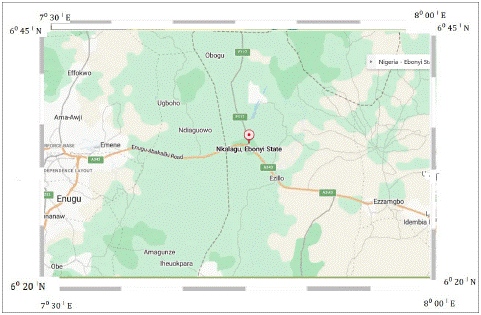
Figure 1: The location map of the study area.
The study area is drained mainly by the Cross River with many tributaries such as Ebonyi and Enyong rivers which in turn empties into the Atlantic Ocean. Its geology is predominantly the geology of the Lower Benue Trough (Figure 2). Stratigraphically, the study area is divided into the Ezeaku group, Asu River Group, and Enugu/Nkporo Shale units [5]. In the study area are the Abakiliki Basin, Afikpo axis basin, and probably other hidden basins. The major formations present in the study area are, the Awgu Shale Formation, Awi Formation, Mamu Formation, and Mkporo Formation.
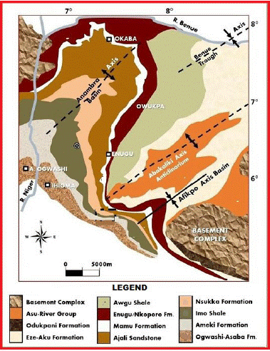
Figure 2: Geologic Map of the Lower Benue Trough.
Materials and Methods
The contoured aeromagnetic data used for this study was obtained as part of the nationwide aeromagnetic survey which was sponsored by the Geological Survey of Nigeria carried out between 2003 and 2010.
Flight line direction was NNW-SSE at a station spacing of 2km with flight line spacing of 2.0km at an altitude of about 150m terrain and a nominal tie line spacing of 20km. Tie lines were flown in an ENE-WSW direction. Regional correction of the magnetic data was based on the International Geomagnetic Reference Field (IGRF) at the epoch of the survey on 1st January 1974. For this study, aeromagnetic sheet 302 was used which covered the area within latitudes 6o20 N and 6o45 N and longitudes 7o30 E and 8o00 E. These maps are published on a scale of 1:100,000. The regional gradients were removed by fitting a plane surface to the data by multi-regression least squares analysis.
The aeromagnetic map was digitized by using a low pass filter by digitizing across the flight lines with a spacing interval of 2km. The aeromagnetic data used were filtered using a low pass filter. The nature of filtering applied to the aeromagnetic data in this study was chosen to eliminate certain wavelengths and to pass longer wavelengths. Analytical methods used include 2-D spectral inversion, trend surface analyses, and second vertical derivative. Another method used in analyzing the residual anomaly is Reduction-To-Pole. The reduction of magnetic data is essential, in order to remove all causes of magnetic variation from the observations other than those arising from the magnetic effects of the subsurface, thus the data obtained was subjected to data reduction and analysis.
Regional and Residual Separation
Regional anomaly is referred to as the component of magnetic anomaly that has a longer wavelength. This deep large feature shows up as regional trends and continues smoothly over a wider aerial extent. The residual anomaly has shorter wavelength and shows up as smaller, local trend which are secondary in size but primary in importance. These residual anomalies may provide structure for mineral or ore emplacement. For effective interpretation to take place, the regional and residual anomalies must be separated. Polynomial Fitting, which matches the regional by the polynomial surface of low order thus exposing the residual features as random errors, was used for the purpose of this study to separate regional and residual anomalies. Thus, the magnetic field of the survey area is expressed by a low-order polynomial given by:
Here, the method of least squares was applied to the observed magnetic intensity to obtain a describable surface, which gives the closest fit to the magnetic field. This surface so obtained is referred to as the regional surface. If the regional surface is expressed as the function
where the coefficients in equation (2) were obtained using the least square method.
Then the residual anomaly function R, for the observed magnetic intensity M is given as:
Where M is the original data grid
Z is the regional data grid.
This process was performed using the algorithm of Radhakrishna Murthy and Krishnamacharyulu (1990) written in Fortran 77 to adjust the polynomial surfaces to the total field magnetic intensity map.
Results and Interpretation
The data obtained from the digitized aeromagnetic total intensity field map were run on the 2xyz program of the United States Geological Service (USGS) Potential Field method (Version 2.2 software) to convert the binary numbers to POST files. The Fortran 77 program was used to view the data on screen to check for errors. World Magnetic Modell (WMM) software computes the main components of geomagnetic fields and their annual changes, provided by the National Centers for Environmental Information. This software produced the minimum and maximum values of X, Y, Z and shows the contour intervals. The surfit plots the cmd file to produce each of the total magnetic intensity maps. Geocon shows the contouring interval
The total magnetic intensity value of the study area varied from 7825.40 nT to above7910.00 nT. The Total magnetic intensity map revealed anomalous low magnetic locations in the study area. This low magnetic intensity embodies low magnetic susceptibility that characterizes sedimentary rocks which are rich in carbonate rock. Nkalagu is rich in limestone which of course is one of the classes of sedimentary rock composed primarily of carbonate minerals.
Residual Separation
The first to fourth-degree (polynomial) surfaces of the regional fields of the aeromagnetic data from the study area show a trend of straight lines or generally, smooth polynomial curves. These represent the major tectonic elements from deeper and regional extent that affect and control the structural framework of the study area (Figure 4). The results of the First to fourth-degree regional anomalies of the aeromagnetic data reveal a dominant regional trend NE-SW trends and some E-W trends.
Reduction to Pole
The reduction to a pole of the total magnetic field intensity map of the study area reveals that there is a negligible shift or no change in the anomalies on reduction to the pole (Figure 3 & 5). This is apparent because the study area is a low latitude zone. The reduction to the pole filter reconstructs the magnetic field of a data set as if it were at the pole.
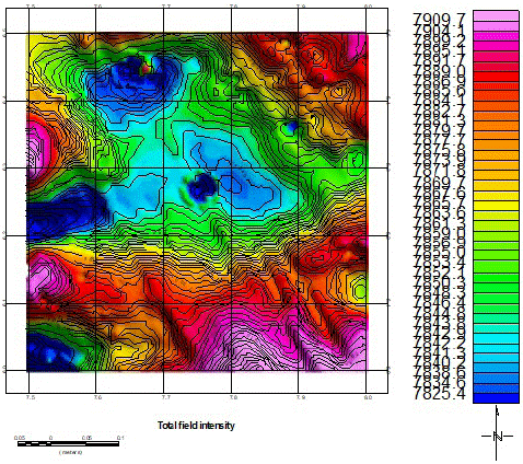
Figure 3: Total magnetic intensity map of the study area contoured in nano Tesla (nT).
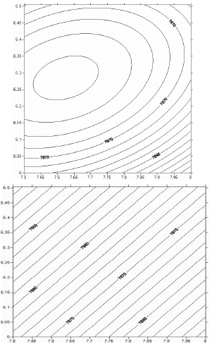
Figure 4: First to fourth-degree (polynomial) surfaces of the regional fields of the Aeromagnetic data.
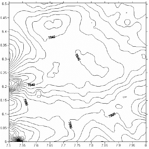
Figure 5: Reduction to the Pole of Total Magnetic Field Intensity (contoured at 10nT).
The closures seen on the second vertical contour derivative (Figure 6) similar to the residual anomalies reflect areas with similar lithology and shallow to near-surface magnetized source bodies. Similar to the total magnetic intensity, it reveals lineaments with NE-SW trend.

Figure 6: Second Vertical Derivatives map of the Study area.
Spectral Analysis
Spectral analysis of the aeromagnetic data of the study area was done using software that runs on MATLAB 7.0. The study area was divided into four (4) blocks (Figure 7) containing 32×32 data points. In doing this, adequate care was taken so that essential parts of each anomaly were not cut by the blocks. Care was also taken to ensure that each block contained more than one maximum, as suggested by Hahn et al (1976). In order to achieve this, the blocks were made to overlap each other. Graphs of the logarithms of the spectral energies against frequencies obtained for various blocks are shown in Figure 8. Each of these plots presents two clear linear segments (the first few points which represent contributions from much deeper sources have been ignored because the reduced dimensions of the areas covered by these sections). The gradients of the linear segments were evaluated and the equation was used to calculate the depths of causative bodies. These depths are shown as D1 and D2 in table 1.
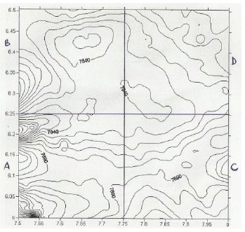
Figure 7: Location of the Spectral Blocks on the map.
The first layer depth (D1), is the depth to the shallower source represented by the second segment of the spectrum (Figure 8). This layer (D1) varies from 0.82km to 1.15km, with an average of 1.041km (Table 1). The second layer depth (D2) varies from 2.863km to 4.67km, with an average of 3.574km (Table 1). This layer may be attributed to magnetic rocks intruded onto the basement surface. Another probable origin of the magnetic anomalies contributing to this layer is the lateral variations in basement susceptibilities, and intrabasement features like faults and fractures [7]. It can be deduced that the D2 values obtained from the spectral plots represent the average depths to the basement complex in the blocks considered. Depth to basement map estimated from spectral inversion of the area was generated (Figure 9). The maps reveal the sedimentary thickness, as thinning towards the NE direction. This direction coincides with areas were the basement outcrops such as the Bamenda massif. The sedimentary thickness of this area ranges from 2.4km to 4.8km.

Figure 8: Energy Spectra for Blocks A, B, C, and D.
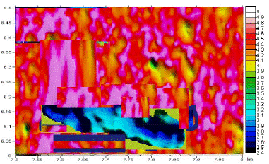
Figure 9: Sedimentary thickness map estimated from spectral inversion.
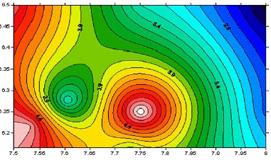
Figure 10: Image map of total aeromagnetic data.
Total Magnetic Field Intensity Map
The total magnetic field intensity map obtained after digitization of the contour map is presented as the total field intensity map, image map, basement surface map, and relief map (Figure 3,11 & 12).
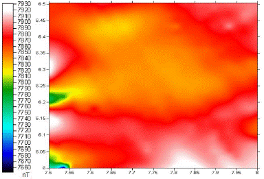
Figure 11: Image Map of the Total Magnetic Field.
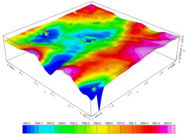
Figure 12: Total field of the aeromagnetic data presented as a 3-D surface map.
From Figures 2 and 11, both short and long wavelengths of magnetic anomalies are seen within the study area. These are represented by magnetic highs and lows. Areas with high magnetic intensity anomalies are seen on the southern flank and around Nkalagu in the study area. At Nkalagu, the intensity ranges from 7900nT to 7930nT. These high-intensity anomalies are interpreted as lineaments due to the tectonic events in the basin. The presence of intrusions may be suspected. Intrusions are described on the aeromagnetic maps by elliptical or circular contours [2]. An elongated linear anomaly which could represent deformation of regional extent is seen towards the southern portion of the Figures mentioned. Generally, the study area is depicted in the Figures, as having moderately low magnetic intensity. Sedimentary rocks and poorly consolidated sediments have much lower magnetizations (Hudson et al., 1999). This portion could be interpreted as a sedimentary area with nonmagnetic materials. The image map and the 3-D relief maps (Figure 10 and 12) respectively show areas of high and low magnetic relief similar to those identified on the total field intensity map (Figure 3). Nkalagu area for instance has a dominant green feature on the 3-D relief map and red on the image map. This corresponds to the lineament seen on the total field intensity.
Discussion and Conclusion
Structural and tectonic interpretation of the aeromagnetic data of Nkalagu and environs was carried out with the aim of delineating the structural trends and depth to basement of the study area. The results revealed a dominant NE-SW trend which reflects that of a basin. A high magnetic intensity and intrusive rock around Nkalagu was delineated and this suggests the existence of deeply penetrating fractures within the area. The 2-D spectral plot revealed that block B, where Nkalagu is situated had a sedimentary thickness of 2.86km.
The results of the spectral analysis of aeromagnetic data over the study area also revealed the existence of two main source depths. The depth to the shallower sources D1 varies from 0.82km to 1.15km with an average of 1.041km and the depth to the basement (deeper source) D2 varies between 2.86km and 4.67km (Table 1). The deeper sources, represented by the first segment of the spectrum reflect the Precambrian basement. Logically, D2 represents the average depth to the basement complex of the study area. The depth to basement obtained from this study is in line with the findings of Ofoegbu and Onuoha (1991) that used spectral analysis of aeromagnetic data in delineating the depth to the basement of a basin to lie between 1.2km to 2.5km. The shallower magnetic layer represented by the second segment of the spectrum (Figure 8) are thought to reflect sources shallower than the Precambrian basement. The second layer is unreliable because of the effect of aliasing. In terms of petroleum prospecting the study seems unprofitable. This owes to the presence of intrusive rocks. The heat accompanying igneous intrusions possibly must have baked the source rocks.
References
- Adepoju MO, Odeyemi IB, Akinluyi FO. Landsat-8 lineament analysis for detection of epigenetic mineralization zones in parts of Igarra schist belt, Southwestern Nigeria. Remote Sens Earth Syst Sci. 2021; 4: 76-86.
- Akanbi ES, Udensi EE. Structural trends and spectral depth analysis of the residual field of Pategi Area, Nigeria, using aeromagnetic data. Nig J Phys. 2007; 18: 271-276.
- Igbokwe JI, Anyomaya T. Gully erosion mapping/monitoring in parts of Southeastern Nigeria. NARSDA News. 2004: 13-5.
- Ananaba SE, Ajakaiye DE. Evidence of tectonic control of mineralization of Nigeria from lineament density analysis: A Landsat study. Int J Rem Sens. 1987; 1: 1445-53.
- Fatoye FB, Gideon YB. Appraisal of the economic geology of Nigerian coal resources. Environ Earth Sci. 2013; 3: 25-31.
- Hahn A, Kind EG, Mishra DC. Depth Estimation of Magnetic Sources by means of Fourier Amplitude Spectra. Geophys Prospect. 2006; 24: 287-306.
- Kangkolo R, Ojo SB, Umego MN. Estimation of basement depths in the Middle Cross River basin by spectral analysis of the aeromagnetic field. Niger J Phys. 1997; 9: 30-6.
- Kogbe CA. The Cretaceous and Palaeogene sediments of Southern Nigeria. Geology of Nigeria. 2nd ed; 1989. Rock View (Nig) Limited 325-334.
- Krishnamacharyulu SKG, Gopalarao BVV, Murthy IVR. Magnetic interpretation of pairs of sheets and their equivalence to dykes. PAGEOPH. 1990; 132: 719-31.
- Murat RC. Stratigraphy and paleography of the Cretaceous and lower tertiary in Southern Nigeria. In: Dessauvagie TFJ, Whiteman AJ, editors, African Geology. Nigeria: University of Ibadan. 1972; 251-66.
- Nannan C, Mengyyan S, Quanlin H, Jienan P. The Impact of tectonic stress chemistry of mineralization process: A preview solid earth science. 2022.
- O’Leary DW Friedman, J.D. & Phn, H.A. Geol Soc Am Bull. 1976. Lineament, linear, lineation: Some proposed new standard for old terms. 1976; 87: 1463-9.
- Odeyemi IB. A comparative study of remote sensing images of structure of the Okemesi folds belt, Nigeria. ITC J. 1993; 1: 77-83.
- Ofoegbu CO, Onuoha KM. Analysis of magnetic data over the Abakaliki Anticlinorium of the Lower Benue Trough, Nigeria. Mar Petrol Geol. 1991; 8: 174-83.
- Okereke CN, Ananaba SE. Deep crustal Lineament inferred from aeromagnetic anomalies over the Niger Delta, Nigeria. J Min Geol. 2006; 42: 127-31.
- Onyedim GC, Awoyemi EA. Aeromagnetic imaging of the basement morphology in the part of the middle Benue Trough. J Min Geol. 2006; 42: 157-63.
- Opara AI. Second vertical derivatives and trend surface analysis of the aeromagnetic data over part of the Benin Basin, Nigeria. Global Journal of Geological. 2010.
- Radhakrishna Murthy IV, Krishnamacharyulu SKG. A FORTRAN-77 program to invert gravity anomalies of sheet-like bodies. Geosciences. 1990; 16: 991-1001.
- Reeves C. Aeromagnetic survey: principles, practice and interpretation. Geosoft; 2005.
- Wenmenga U. Landsat and aeromagnetic interpretation of the structural features of the palaeo-Proterozoic basement of Boussouma area, Burkina Faso. J Min Geol. 2005; 4: 33-40.
- Zaborski PM. A review of the Cretaceous system in Nigeria. Afr Geosci Rev. 1998; 5: 385-400.