Abstract
The single-most important purpose of this observational successful earthquake prediction research is to mitigate the loss of life and destruction of property by earthquakes. The basic innovative concept is entirely new and related to the tectonic plate activities of epicenter zones, may not familiar to many and may not be readily found in the existing literature. This manuscript is prepared based on 35 years of earthquake prediction study and over 10 years of observation of onshore observable precursors and the corresponding earthquakes. Past precursory phenomena for earthquakes have been observed, recorded, analyzed and can be used to predict future earthquakes for seismically risky regions, Japan, California and Mexico. It is significant to mention that there are more than 250 epicenter zones and equal number of precursor areas identified, centrifugal force due to the orbital motion of the earth is the major driving force of tectonic plates, each and every epicenter zone has its own creation of atmospheric weather anomalies, due to the change in position of the orbital motion of the earth. Though all form of weather anomalies are preceded by earthquakes, among them rainfall is the best earthquake precursor and rainfall location is best to identify the future earthquake direction, location frame, time frame and magnitude frame can be established 15 days before earthquakes occur. Based on this prediction method each and every individual earthquake can be predicted without false alarm in Japan, California and Mexico.
Keywords: Orbital motion of the earth; Centrifugal force; Tectonic plate motion; Epicenter zone; Precursors; Atmospheric weather anomalies and earthquakes
Introduction
This observational earthquake prediction study based on the innovative concept of tectonic plate motion of epicenter zones. There are several unsuccessful earthquake prediction papers have been published over the past 60 years. The main reason for failure to predict earthquakes are due to the wrong understanding of major force behind the tectonic plates, epicenter zone concept of cyclone formation and failure to connect the atmospheric weather phenomena with seismic phenomena. Epicenter zone comprises movable tectonic plates. Centrifugal force due to the orbital motion of the earth triggers tectonic plate motions of epicenter zones. Orbital motion of the earth with 23.5° tilt causes seasonal variation on earth every year at same places. Each and every epicenter zone have its own creation of all forms of atmospheric weather anomalies and are seismically related precursor. The change in position of the orbital motion of the earth causes different atmospheric weather anomalies at different epicenter zones. So, the seasonal atmospheric anomalies are always followed by seismic activity. Atmospheric weather anomalies are the preparatory phase for earthquakes to occur [1].
Some Type of Natural Disasters
Earthquakes, Volcanoes, Landslides, Famines & Droughts, Hurricanes, Tornados, and Cyclones. Extreme precipitation and flooding. Extreme Temperature (Heat & Cold) and Wildfires.
Misleading Driving Force for Tectonic Plates
There are more than one solution are describing about the driving force for tectonic plates. Some of them are thermal convection, heat within the Earth, ridge push and slab pull, convection currents and more.
Centrifugal Force Due to Orbital Motion of the Earth is the Major Driving Force of Tectonic Plates
It is found that the major driving force of tectonic plates and yearly seasonal variation at different regions of epicenter zones are related centrifugal force due to the orbital motion of the earth. Both atmospheric and seismic anomalies of varying severity level due to the change in position of the orbital motion of the earth with reference to the Sun.
Unsuccessful Earthquake Precursors and Precursors Study and Analysis
Animal behavior, Dilatancy-diffusion, Changes in Vp/Vs, Radon emissions, Electromagnetic anomalies, Now casting, Elastic rebound, Characteristic earthquakes, Clusters of earthquakes and slow-slip events, fault-slip behaviors and more.
Methodology: Earthquake Prediction and Prediction Criteria
• Earthquake related Precursor: Atmospheric weather anomalies.
• Best precursor: a) Rainfall and Rainfall location; b) Snowfall location (Seismic activity in case of absence of rainfall).
• Amount of rainfall: 50mm and above [2].
• Distance of future Earthquake location with respect to rainfall location: a) Mostly within 15°; b) In some cases up to 20°plus.
• The direction of low depression/ storm/cyclone/typhoon and hurricane generation would be the direction or orientation of future earthquake location. The orientation of earthquake location from rainfall location varies from region to region, due to space constraint, only limited regions tabulated.
• Magnitude: a) Depending on site geological conditions and severity of weather changes; b) Mostly within 4-6 on Richter scale (lower magnitude not recorded).
• The time lag between precipitation/snowfall and seismicity mostly within 15 days (Table 1).
    JAPAN: 17
    MEXICO: 31


    Hokkaido, Japan
    Offshore Tamaulipas, Mexico


    Near East coast of    Honshu, Japan
    Off coast of Nayarit, Mexico


    Near S coast of Honshu,    Japan
    Offshore Veracruz, Mexico


    Eastern Honshu, Japan
    Offshore Jalisco, Mexico


    Off East coast of    Honshu, Japan
    Offshore Guerrero, Mexico


    Sea of Japan
    Offshore Oaxaca, Mexico


    Near S coast of W    Honshu, Japan
    Offshore Chiapas, Mexico


    Shikoku, Japan
    Offshore Colima, Mexico


    SE Shikoku, Japan
    Offshore Michoacán, Mexico


    Kyushu, Japan
    Off coast of Chiapas, Mexico


    Ryukyu, Islands, Japan
    Off coast of Sinaloa, Mexico


    SE of Ryukyu, Islands,    Japan
    Off coast of Jalisco, Mexico


    SW of Ryukyu, Islands,    Japan
    Off coast of Colima, Mexico


    North West Ryukyu,    Islands, Japan
    Off coast of Michoacan, Mexico


    Izu Island, Japan
    Off coast Oaxaca, Mexico


    Bonin Islands
    Revilla Gigedo Islands


    Volcano Islands, Japan
    Chihuahua, Mexico


    Nuevo Leon, Mexico


    CALIFORNIA: 9
    Queretaro, Mexico


    Off coast of Northern California
    San Luis Potosi, Mexico


    Offshore Northern California
    Jalisco, Mexico


    Northern California
    Michoacán, Mexico


    Offshore Central California
    Tabasco, Mexico


    Central California
    Durango, Mexico


    Greater Los Angeles area, Calif.
    Coahuila, Mexico


    Southern California
    Nayarit, Mexico


    Gulf of California
    Veracruz, Mexico


    Revilla Gigedo Islands region
    Chiapas, Mexico


    Oaxaca, Mexico


    Guerrero, Mexico


    Baja California, Mexico
Table 1: Number of epicenter zones in Japan, California and Mexico.
Japan
Japan archipelago comprises 16,000 Islands, among them Hokkaido, Honshu, Shikako, Kyushu are the major Islands and has 17 epicenter zones.
Season: Japan has different seasons, like typhoon, rainfall, snowfall and forest fire at different duration of time.
The snow season: Long and in some places begins as early as November and lasts into May, with the peak being in February.
Pacific Typhoon Season: May to October each year, August and September are the peak. Since, all form of season and atmospheric seasonal variations are the creation of epicenter zones, they are seismically related precursor to earthquakes.
The generation process of earthquake is always preceded by at least one or more atmospheric weather anomalies, it may be heat waves, rainfall, snowfall accompanied with strong winds. The lead time between atmospheric weather anomalies followed by earthquakes of Magnitude 4-6 is normally 10-15 days in some cases it takes 2-4 weeks. Only record rainfall or snowfall may followed by earthquakes of magnitude above 6 cause devastating effect. One interesting information, rainfall accompanied with snowfall followed by earthquakes are stronger than rainfall alone. In general, the direction of storm formation would be the direction for future earthquake. For Japan epicenter zones are to the east of precursor (rainfall and snowfall) area [3,4].
The amount of rainfall equal or above 50mm at one or more location is quite easy and quick to record than snowfall quantity, then the rainfall location is used to instantly identify the future earthquake direction, time frame (10-15 days after rainfall/snowfall), Location frame, depending on rainfall location the resulting earthquakes locations would be at same or within 5° latitude and normally up to 15-20° longitude variation and magnitude frame (M4-6 on Richter scale) (Map 1 and Table 2-4).
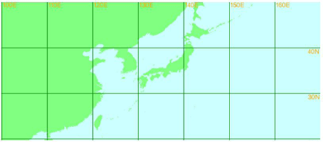
    map 1: Seismically more active and vulnerable Epicenter zone range,
Honshu, Japan: 34-36N; 140-141E.
    Major Epicenter Zones
    Geological co-ordinates of precursor areas
    Geological co-ordinates of Epicenter Zones


    Hokkaido
    38-44N; 124-145E
    40-45N; 140-149E


    Honshu
    31-40N; 122-140E
    33-39N; 139-144E


    Shikoku
    31-34N; 129-133E
    32-33N; 132-134E


    Kyushu
    29-34N; 129-134E
    30-32N; 130-131E


    Izu Islands
    24-35N; 125-135E
    29-32N;138-141E


    Bonin Islands
    22-27N; 121-129E
    26-29N; 138-141E


    Ryukyu islands
    24-32N; 115-129E
    25-29N; 125-131E


    Southwestern Ryukyu    Isl.,
    24-30N; 106-119E
    24-25N; 123-125E


    Volcanic Islands
    22-28N; 125-129E
    22-23N; 143-145E
Table 2: Geological co-ordinates range of precursor areas and Epicenter Zones.
Japan
Seasonal variations
March 11, 2011
Near the East Coast of Honshu, Japan
M9.1/38.30°N; 142.37°EThe snow season in Japan is long and in some places begins as early as November and lasts into May, with the peak being in February.
March 2, 1933
Off the East Coast of Honshu, Japan
M8.4/39.21°N; 144.59°E
Table 3: Past Seasonal variations related devastating earthquakes in Honshu,
Japan.
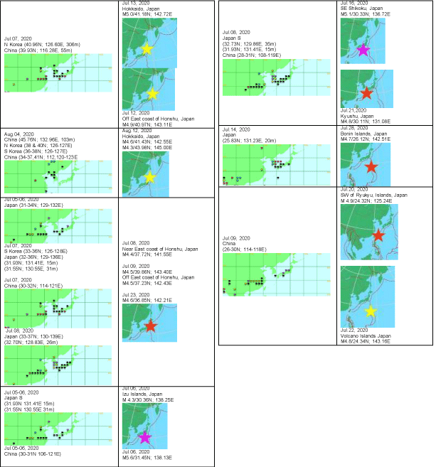
    Table 4: Japan is seismically more active in July August and September 7. Result: Few sample of events data of rainfall/snowfall/heatwave/wild fire followed by
earthquakes.
The Star icons represent the geological coordinates of rainfall location (left column) and earthquakes at corresponding location (right column) Samples of rainfall
precursor before earthquakes at different regions of Japan.
California: Much Debated San Francisco, California Regions
California has 8 islands, 9 ECZs and has hurricane, rainfall and snowfall season. Earthquakes occurs at peak season only. Precursors from Western US and earthquakes are in same region.
Seasons in California
Wildfire season: May through October, but wildfires can occur at any time.
Hurricanes season: May is the least active month, while September is the most active.
Snowfall season: November through April is the rainy season in California. Areas like the high country of the Sierra Nevada, where mountains reach over 14,000 feet, can get as much as 38 feet of snow over the course of the season.
Prominent weather changes, Hurricane, release of massive amount of tectonic plates of frictional heat cause snowfall originate from Western US.
Snowfall: From Seattle, Wash, to Portland, Ore.
Heavy Rain and Snow for the Northwest: Colorado Avalanche.
Severe weather outbreak (deadly Tornados (166 to 200 mph) Sweeps) Midwest (Table 5-7 and Map 2).
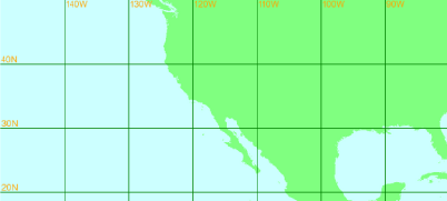
Map 2:
    Major Epicenter Zones
    Geological co-ordinates of    precursor areas range
    Geological co-ordinates of    Epicenter Zones range


    North to South    California
    11-47N; 93-124W
    19-41N; 127W
Table 5: Geological co-ordinates of precursor areas and epicenter zone range.
Major Epicenter Zones
Geological co-ordinates of precursor areas
Geological co-ordinates of Epicenter Zones
Off coast of Northern California
Snowfall
Off coast of Northern California
40.48N; 127.08WNorthern California
40,47N; 122, 124W
Snowfall: from Seattle, Wash., to Portland, Ore.
Heavy Rain and Snow for the Northwest: Colorado Avalanche.
Severe weather outbreak (deadly Tornados (166 to 200 mph) Sweeps) Midwest.Northern California
38-41N; 122-124WCentral California
Big Temperature Swings for Midwest, Northeast
Central California
36-37N; 117-118WGreater Los Angeles area, Calif.
Heat wave and wild fire
Greater Los Angeles area, Calif.
34-35N; 118-119WSouthern California
Arizona (34N; 112W) wildfire grows to 5,000 acres
Southern California;
33-34N; 115-117WGulf of California
23-32N; 93-111W
Gulf of California
23-30N; 106-113WRevilla Gigedo Islands region
11-17N; 97-107W
19-20N; 108-109W
Table 6: California precursor area range and epicenter zone range.
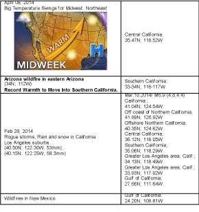
Table 7: Sample observation of precursor and corresponding earthquakes in California region.
Mexico
Astounding observation results, atmospheric weather anomalies of US Southern Gulf States drastically affected by:
Mexico epicenter zones
Mexico archipelago has 100 Islands, 31 epicenter zones , with this more number of epicenter zones, triggering yearly 800 extremely deadly tornadoes and continuous atrocious atmospheric weather anomalies in US southern Gulf states and seismically active all through the year. Precursor area in US Southern Gulf states and epicenter zones in Mexico, has separate precursor areas [5].
Season: The forest fire season normally occurs between January and July.
Hurricane season in Mexico officially lasts from the beginning of June through the end of November, but you’re at greatest risk of encountering a hurricane between the months of August and October.
Rainy season from June to mid-October and significantly less rain during the remainder of the year. February and July generally are the driest and wettest months, respectively [6,7].
The lead time between precursor generation and earthquake generation is usually 10-15 days in exceptional case it may extend to 2-4 weeks. Storms are originated from Gulf of Mexico, so the south of precursor area (US Southern Gulf states) is epicenter zone (Gulf of Mexico). Distance within 20-25° latitude (Table 8,9 and Map 3).
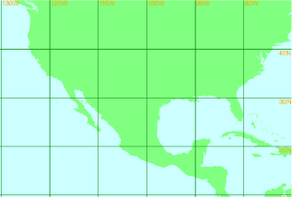
    Map 3: Geological co-ordinates of precursor areas: 29-32N; 81-102W, US
Gulf States Geological co-ordinates of Epicenter Zones, Mexico: 14-27N; 91-
107W.
Mexico
Range of Geological co-ordinates of precursor areas
Range of Geological co-ordinates of Epicenter Zones, Mexico
Rain in US-Mexico
US:28-30N; 80,85,88,93-102W
Mexico:16-22N; 88,92-98,102-104WChiapas, Mexico: 15-16N; 92-93W
Offshore Chiapas, Mexico: 14.368°N; 93.305°W
Oaxaca, Mexico: 16-17N; 94-98W
Offshore Oaxaca, Mexico: 16N; 94-95WStorm in US
Central Gulf coast and into parts of Mississippi and Alabama.
This includes New Orleans, Baston Rouge, Mobile, Jackson and Montgomery.Veracruz, Mexico: 17.966°N; 95.071°W
Offshore Veracruz, Mexico: 18.334°N; 94.306°W
Offshore Jalisco, Mexico: 18.863°N; 104.959°W
Table 8: Weather precursor in US Southern Gulf states and series of earthquakes in Mexico.
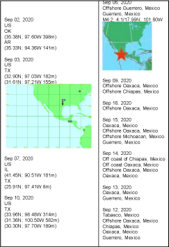
    Table 9: Rainfall in US Southern Gulf States and earthquakes in corresponding
epicenter zones in Mexico.
Conclusion
Every year the change in position of orbital motion of the earth causes different atmospheric weather changes at different epicenter zones. This study strongly demonstrates the relationship between nature’s atmospheric weather anomalies and the occurrence of earthquakes; driving force of tectonic plates identified and explained by illustration then the observed few events of rainfall followed by earthquakes.
No equipment, no instrument used, no expense and daily rainfall map only used. Over the last 35 years of this earthquake prediction research study and over 10 years of rigorous observation of both the earthquake precursor and earthquake events scientifically convincing and notably successful [8-10].
Successful Findings
Tectonic plate motion
• Gravitational force plays a major role in moving objects in the Universe.
• Strongest centrifugal force, due to the orbital motion of the earth is the major driving force of tectonic plates.
Successfully identified
• More than 250 epicenter zones and equal number of precursor areas. Japan has 17, California has 9 and Mexico has 2.
• The different epicenter zones are set to more active at different position of the earth with reference to the Sun.
• Devastating earthquakes are also seasonal related, as tectonic plates are always in motion cause minor earthquakes are happening all through the year.
• It is verifiable and testable in just 15 days.
• In general earthquakes are short-term nature just 2-4 weeks, vary in exceptional case.
• Scientific reason for short term nature of earthquakes found
• The capacity to predict earthquakes 100% without false alarm even without the need of statistical and mathematical model.
• Basic physics is enough to predict earthquakes reliably.
• Earthquake predictions are easy and no expense. Every individual earthquake can be predictable.
• Orientation of earthquake location could be identified.
• Sequence of natural events leads to earthquakes identified.
• All form of weather anomalies are always prior to seismic anomalies for the corresponding epicenter zone, this is the most significant findings in this observation study.
• When seasonal variations for different region of the earth is associated with the position of the earth with respect to the Sun, then the process of earthquakes are also related with seasonal variations.
• In future studying the position of the earth with respect to the Sun, reveal the secret of massive earthquakes and tsunamis in the year Dec 26, 2004, Indian Ocean and March 11, 2011, Japan.
• The safe earthquake prediction method for Japan, California and Mexico regions are over.
• This observational earthquake research studies are the great service to the humanity.
Availability of Data and Materials
The meteorological data daily rainfall location was obtained from www.http://severe.worldweather.wmo.int/rain/b5/ and other weather events gathered from wunderground.com/hurricane; gdacs. org; earthobservatory.nasa.gov/Natural Hazards and journals.
Seismic data required to evaluate the conclusions in the paper are available from https://www.emsc-csem.org/Earthquake/world/M4/.
Declaration
Availability of data and material
For rainfall and snowfall http://severe.worldweather.wmo.int/ rain/b3/index.html.
Authors’ contributions
Text prepared, data collection and analysis all performed by me only.
Acknowledgments
I would like to pay my greatest regards to (late) Prof. Dr. K.V Gopalakrishnan, IIT, Madras, Mrs.Vasantha Gopalakrishnan, Mr. K.V.G. Sundararaman, Oracle, New Delhi, India, Mrs. Padma, California, USA, Dr. P. Srinivasulu, SERC, CSIR, Madras (Retd), (late) M. Kalidas Managing Director, KEL, Tiruchi, Tamilnadu (I was worked in the Mechanical Destructive Lab). India and my parents; wife P. Bhuvaneswari, my daughters P. Aparna and P. Aravindha and well-wishers for their affectionate support to my continuous hectic 35 years of earthquake prediction study and 12 years of continuous data observations of both atmospheric weather changes and earthquake events, though they are not experts in this field.
I would like to show my whole-hearted gratitude to (late) Dr. V. Shantha, Chairman, Adyar Cancer Institute, Chennai. Dr. Venkatraman Radhakrishnan and Dr. Aravind, Adyar Cancer Institute, Chennai, India, where I am taking the best medical treatment and helping me to get second lease of life to serve this humanity.
I also immensely grateful to Dr. Michael Blanpied, NEPEC Secretary, USGS and Dr. Zechar then CSEP, CalTech, California arranged his students to test my hypothesis. Also my sincere thanks to Prof. Dr. R. Chandramohan, Principal, Sree Sevugan Annamalai College, Devakottai, Tamilnadu State, India and Prof. Dr. A. T. Ravichandran, Department of Physics, National College, Tiruchi, Tamilnadu, India for valuable suggestions in this observation research study and ‘Dinamalar’ Mahendran, for continuous support.
I could not do this historic landmark achievement that beneficial to the entire humanity without the support data source of the websites: (http://severe.worldweather.wmo.int/rain/b5/); (www. wunderground.com/hurricane); (http://www.emsc-csem.org/ Earthquake/world/M4/).
References
- Pillai SP. Breakthrough in Earthquake Prediction a New Perspective: Philippines and Taiwan. Austin J Earth Sci. 2021; 4: 1022.
- Pillai P. Exploring E Turkey: Rainfall Precursor Predicts 100% Earthquake in a Consistent Manner in Just 2 Weeks. International Journal of Geosciences. 2013; 4: 759-765.
- Sikka. “Major advances in understanding and prediction of tropical cyclones over north Indian Ocean: A Perspective”. Mausam. 2006; 57: 165-196.
- Thomas A, Pringle P, Pfleiderer P, Schleussner CF. Briefing Note on Tropical Cyclones: Impacts, the link to Climate Change and Adaptation”.
- Yaoling Niu. Geological understanding of plate tectonics: Basic concepts, illustrations, examples and new perspectives. Global Tectonics and Metallogeny. 2018; 10: 23-46.
- Coltice N, Husson L, Faccenna C, Arnould M. “What drives tectonic plates”? Science Advances. 2019; 5.
- JF Harper. On the Driving Forces of Plate Tectonics. Geophysical Journal International. 1975; 40: 465-474.
- Yeshayahu Greitzer. The Centrifugal Force behind the Movement of Continents, Change in the Axis of the Rotating Earth. Journal of Science and Technology. 2020; 5: 69-80.
- Bernard S and Richard J. The convective mantle flow signal in rates of true polar wander, in Ice Sheets, Sea Level and the Dynamic Earth. Geodynamics Series 29, American Geophysical Union. 2002.
- Pritchard ME, RM Allen, TW Becker, MD Behn, EE Brodsky, R Bürgmann, et al. New Opportunities to Study Earthquake Precursors. Seismol. Res. Lett. 2020; 20: 1-4.
