
Research Article
Austin J Environ Toxicol. 2021; 7(1): 1034.
A Quantitative Study of Hydraulic Parameters of Thamirabarani River
Gopikumar S¹*, Sundararajan S², Gladston JAK², Kumar CAV² and Babu KH²
¹Department of Civil Engineering, SCAD College of Engineering & Technology, India
²Department of Mechanical Engineering, SCAD College of Engineering & Technology, India
*Corresponding author: Gopikumar S, Department of Civil Engineering, SCAD College of Engineering & Technology, Tamil Nadu, India
Received: January 18, 2021; Accepted: February 16, 2021; Published: February 23, 2021
Introduction
Each channel has unique characteristics of its own; River Thamirabarani being no exception. The project proposal aims at investigating the hydraulic geometry of the Thamirabarani River from Pothigai to the downstream up to Srivaikundam [1]. The interrelationship among stream sediment load, channel width and channel depth shows the nature of hydraulic geometry of Thamirabarani River channel. Due to the effect of Papanasam dam the natural flow of this river has been obstructed, and this is resulting in reduced discharge at downstream [2]. Confluences of major tributaries such as Manimuthar, Servalaru, Gadana and Ramanadhi may play significant role for the influx of extra discharge and sediment load to the main river. This extra sediment influx is also responsible for frequent bar formation in the river channel. The input morphometric maps have to be prepared using GIS and Remote Sensing tools like Arc GIS 10.1 and Global Mapper [3].
Literature Review
Recent studies identified that the characterization of spatial variability in earth science commonly requires random fields, which are stationary within delineated domains. This contribution presents an alternative approach for simulating attributes in combination with a non-stationary first-order moment [4]. A new procedure is presented to unambiguously decompose the observed behaviour into a deterministic trend and a stochastic residual, while explicitly controlling the modelled uncertainty. The practicality of the approach resides in a straightforward and objective inference of the variogram model and neighbourhood parameters [5]. This method does not require a prior removal of the trend. The inference principle is based on minimizing the deviation between empirical and theoretical errors calculated for increasingly distant neighborhood shells. Further, the inference is integrated into a systematic simulation framework and accompanying validation guidelines are to be formulated. The effort results in a characterization of the resource [6].
Objectives
1. To study the adjustments to flow width, depth and velocity in response to changes in discharge downstream hydraulic geometry relationships.
2. To characterize channel depth, velocity, grain size of the river bed towards the downstream.
3. To analyze the channel discharge, width, hydraulic radius and wetted perimeter of the river towards downstream.
Methodology
The extent and dimension of the study area is to identify from Google earth image and to verify with the help of hand held GPS. Velocity of the river water is to measure by using digital current meter. Discharge (Q) has been calculated using formula Q=A*V, where ‘A’ represents cross-sectional area and ‘V’ represents velocity of water (cumec). Hydraulic Radius (HR) is to calculate using a formula, HR=Cross-sectional area/Wetted perimeter. Suspended sediment load is to measure using filter paper and grain size analysis using sieves. For grain size analysis, bed materials is to collect at every cross sectional spots [7]. Field related calculation data is to analyze through statistical tools and is to be represented by suitable diagrams. Morphometric maps have to be prepared using GIS Platforms Arc GIS 10.1 and Global Mapper and Google Earth [8].
Work Plan
River Thamirabarani markedly alters the flow and sediment load as well as deposition character downstream. But sometimes sudden release of water from the dam causes the velocity and turbidity to increase. As a result, abnormal behaviour of the flow has been observed few kilometres downstream from the dam.
Practical Approach to Simulate and Validate River Morphology with Complex Trends
Velocity of a river is influenced by different dynamic parameters like slope gradient, roughness of the bed, width, depth etc (Figure 1). The Spatial variation of velocity and discharge of the river are major parameters. The channel width is assessed with downstream distance and width. The Depth of a river depends on several factors like bed and bank material, velocity, discharge etc. Comparative study is to carry out for the following parameters such as Correlation between velocity and discharge of the river. The correlation between downstream distance and width of the river are to be assessed. Spatial variation of cross sectional area, wetted perimeter and hydraulic radius are to be evaluated. Hydraulic radius and grain size analysis is an important indicator, which represents the efficiency of a river channel [9].
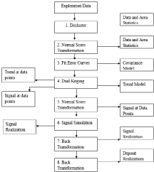
Figure 1: Proposed Model.
Outcome
From the proposed model it is to observe the variables that following the normal law of downstream variation but some are disturbed by other factors, like construction of dam on the river channel. Changes in downstream channel morphology of Thamirabarani River below the Papanasam dam are to check for its documentation through different variables and parameter.
Budget Particulars (In Rupees)
See Table 1.
![]()
    S. No.
    Item
    Week 1
    Week 2
    Week 3
    Week 4
    Week 5
    Week 6


    1
    Prism Reflector
    5000
    -
    -
    -
    -
    -


    Sub-Total (A) = 5,000.

      B. Recurring.
Table 1: A. Non-Recurring (e.g. equipments, accessories, etc).
Any other Details
Space - Project work will be completed in the site location.
Equipment - Survey and Hydraulics Lab Equipments.
Academic disciplines and other skills - Engineering, Civil, Language (for possible translation).
Safety issues - Curing tests will be done per standard procedures.
References
- Alfa MI, Owamah HI, Onokwai AO, Gopikumar S, Oyebisi SO, Smita SK, et al. “Evaluation of biogas yield and kinetics from the anaerobic co-digestion of cow dung and horse dung: a strategy for sustainable management of livestock manure”. Energy, Ecology and Environment. 2020.
- Owamah H, Alfa M, Oyebisi S, Emenike P, Otuaro E, Gopikumar S, et al. “Groundwater quality monitoring and perception issues in a popular Niger Delta university town in Nigeria”. Groundwater for Sustainable Development. 2020.
- Gopikumar S, Raja S, Robinson YH, Shanmuganathan V, Rho S. “A Method of Landfill Leachate management using Internet of Things for Sustainable Smart city development”. Sustainable Cities and Society. 2020.
- Agu MJ, Gopikumar S, Vimal S, Robinson YH. “Failure assessment of pressure vessels made of plain carbon steel by using modified inherent flaw model in DL based industry optimization intelligent processing”. Measurement. 2020; 165: 1-8.
- Kumar MD, Kaliappan S, Gopikumar S, Zhen G, Banu JR. “Synergetic pretreatment of algal biomass through H2O2 induced microwave in acidic condition for biohydrogen production”. Fuel. 2019; 253: 833-839.
- Gopikumar S, Arul P, Kavitha S, Kumar SA, banu JR. “Evaluation of operational parameters for anaerobic digester treating pretreated waste activated sludge”. Desalination and Water Treatment. 2015; 57: 9093-9100.
- Gopikumar S, Merrylin J, Kaliappan S, Adish kumar S, Yeom IT, banu JR. “Effect of cation binding agents on sludge solubilizing potential of bacteria”. Biotechnology and Bioprocess Engineering. 2012; 17: 346- 352.
- Dinesh Kumar M, Gopikumar S, Adish Kumar S, Uan DK, Banu R. Chapter 2, “Constructed Wetland: An Emerging Green Technology for the treatment of Industrial Wastewaters”, Title: Emerging Eco Friendly Green Technologies for Wastewater treatment. 2020; 1: 21-44.
- Gopikumar S, Tharanyalakshmi R, Kannah RY, selvam A, Banu JR. Chapter 11“Aerobic Biodegradation of Food waste”. Title: “Food Waste to Valuable Resources”. 2020; 1: 235-250.