
Research Article
Austin J Hydrol. 2015;2(1): 1012.
Paleoflood Analyses in Southeastern Turkey: Batman Case
Murat Sunkar* and Saadettin Tonbul
Department of Geography, Firat University, Turkey
*Corresponding author: Murat Sunkar, Department of Geography, Firat University, Faculty of Human and Social Sciences, Elaziğ, Turkey
Received: March 04, 2015; Accepted: May 06, 2015; Published: May 13, 2015
Abstract
In this study, paleoflood analyses were performed in order to determine the frequency of flood and overflow incidents which have caused loss of life and property in Batman in recent years. Batman, founded as Iluh village in Southeastern Turkey, is now a city thanks to developments in oil industry in migration from rural areas within 50 years. The number and frequency of floods are increasing as city center expanded to the river bed. Sediment log wells are opened to determine paleoflood features. Thermoluminescence and radiocarbon analyses are applied to the samples collected from log wells near Iluh riverbed where river fan widens. The sedimentological data revealed that 3 catastrophic flood occurred at present location of the city center. Radiocarbon analyses (14C) dated the first flood 1420±21 years BP, the third was dated back to 220±25 years BP. According to historical data, the period of the second flood between the first and third one dates back to 800 years BP. Thermoluminescence analyses showed a decrease in flood energy from past to present. Other than these analyses, regional scaled geoarchaeological and historical data and studies on the climate changes were compared and the accuracy of the discovered dates was tested.
Keywords: Paleofloods; Batman; İluh creek; Thermoluminescence (TL); Radiocarbon dating
Introduction
The number and frequency of floods in Turkey increased during 1990-2012. Some of the flood events were devastating, caused loss of life and property throughout the country. Contemporary floods are studied by researchers particularly geographers [1-8]. Unfortunately studies on plaeofloods have never been outlined in Turkey. Thus, our study is first of its kind in Turkey that documented characteristics of plaeofloods. However, several paleoflood studies have been throughout the world that gave clues for possible future flood events, e.g., [9-26].
Batman city was founded in the area of Iluh Creek which was once not linked to Batman Stream. The city developed rapidly and became a medium-sized industrial city after 1970 (Figure 1). From then onwards, an increase was observed in the incidence rate and frequency of flood and torrent events causing great loss of life and property. The flood and torrent events occurred almost every year in the city after intense precipitations were observed in Iluh Creek and its branches. The last flood that occurred on October 31 to November 1, 2006 resulted in 10 deaths and a material damage on loss of 20 million dollars (Figure 2).
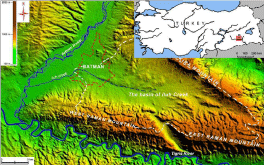
Figure 1: Location of the study area.
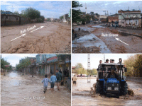
    Figure 2:  Great loss of life and property occurred in Batman city due to the
overflow of Iluh Creek from October 31 to November 1, 2006.
Iluh Creek is a seasonal stream which drains the waters of an area located between Mountain Kira and Raman in the Southeastern Anatolia Region. This creek is linked to Batman Stream in the west of Batman city. With its pyramidal shape, it collects the waters of an area of 316 km2 (Figure 3). The wide basin area and seasonal characteristic of the creek is of utmost importance with regard to the occurrence of flood and torrent events following downpours.
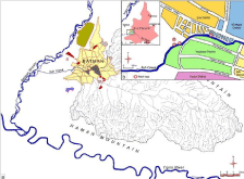
    Figure 3:  (a) Iluh Creek which has a seasonal flow and affects Batman city,
(b) Location of the wells logs in Çay District of Batman city.
For protection from hazardous floods, estimation of floods is of utmost importance which can be possible by well defining past floods retrieving sedimentological data, historical archives records, and analyzing official documents. Historical document would yield efficient data for investigating past hydrogeologic events [27]. Ultimately, differentiation of natural and human induced floods will outline the causes of paleofloods for effective protection and/or control. Thus, the frequency, magnitude and intervals of floods along with climatic fluctuations are studied for Batman region.
There are many studies of us on the flood in Batman in 2006 [28- 31]. As the flood was analysed with different aspects in those studies, detailed evaluations haven’t been made in this article. Being different from our previous studies, paleoflood analyses were performed in order to determine the frequency of the floods which took place in Batman. Different methods which are used very often in the paleoflood analyses were applied as there were no hydraulic data of the stream in which the flood was seen. The first method is composed of sedimentological analysis (1), and the second one is composed of dating the findings resulting from these analyses (2). In order to test the accuracy of the age data, historical and geoarchaeological studies of the region were reviewed (3). With all these studies, the researches on the sedimentologic and pollen analyses which put forward the climate changes were evaluated (4). As a result of these evaluations, the findings of 4 different methods were compared and paleoflood periods in Batman were determined. Also it was seen that, geoarchaeologic, sedimentologic and pollen analyses were qualified to shed a light on the flood periods in Late Holocene.
Method and Data
Paleoflood studies require inputs of geomorphology, sedimentology, hydrology, hydrologic modeling and statistical data processing [32]. The paleoflood analyses of Batman city were performed by utilizing satellite images, 1/25.000 topographic maps, field surveys, on sedimentology and geomorphology, and sediment log wells. Since Iluh stream has seasonal flow (Figure 3a), majority of the sediment is repeatedly deposited in the alluvial fan, and so samples were collected from the fan for analyses. A total of four log well were dug and cleared for sediment designation at river terraces of Iluh Creek (Figure 3b).
In the field observations, the places in which sedimentologic observatory wells would be opened were determined. As İluh Creek has seasonal flow, it was determined that the most suitable areas were the ones in which the fan formed by this creek started to widen. In accordance with this decision, 4 observation wells were opened in Çay District İluh Creek Bed and its periphery with a simple construction vehicle. In the observation wells which were opened later, cleanings were carried out in the parts from which the profiles would be taken.
Transported pottery shards were found in log wells within gravel layers. Moreover, bone fragments weighing less than 50g were detected as well. Samples were stored in black plastic bags for avoiding exposure of samples to direct sunlight since exposure might cause anomalies during Thermoluminescence (TL) and radiocarbon analyses.
The samples taken from various depths (section number 2 170- 190, 200-215 and 260-290 cm, Figure 6, 8) in the study area for the thermoluminescence analyses were put into black plastic bags in order for them not to be affected by the sun rays [33]. Electrons of the sun rays which are trapped to directly come to the samples especially affected them after 40°C and they formed negative results in TL readings [34]. Due to lack of measuring annual doses, TL analyses were undertaken by comparing relative weathering levels of shards [35]. The TL sample preparation was based on fine grain method [36]. The surface layer of shards was first removed from the surface. The remaining sample was crushed and powdered in an agate pestle and mortar. The grains sized from 4 to 11 μm (fine grains) were treated with HCl to neutralize carbonate, and washed with diluted water. Unirradiated samples were taken to obtain the natural TL signal and the remaining samples were irradiated for 5 minutes for artificial doses.
The bone fragments thought to be of human and animal origin were dated by 14C. Radiocarbon measurement is required for precise dating in paleohydrology studies [37,38]. Historical and geoarchaeological findings and sedimentologic and pollen analyses were compared in order to ensure that bone fragments which were found as a result of the sedimentologic analyses reflected the flood periods. As a consequence of the comparison, radiocarbon age results and other analyses results were found to be consistent.
Findings
Detailed geomorphologic observations, sedimentologic and thermoluminescence analyses and radiocarbon dating were made in order to reveal the paleofloods that occurred in Batman and its vicinity. The findings acquired were compared with the historical and geoarchaeological data and the following results were obtained.
Geomorphological and sedimentological findings
Batman city was founded on the old meander terraces and the new alluvial fans of Batman Stream. These terraces are split by Iluh Creek in the area where the city was founded (Figure 4). The valleys of creeks affecting the area where Batman city was founded are quite apparent and have a deep structure in the upper basins. The stream beds in the foundation area of the city were destroyed due to low inclination as a result of urbanization
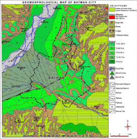
Figure 4: Geomorphological map of Batman city [28].
In geomorphological observations along the valleys of Tigris River and Batman Stream, flood materials were found in the terrace deposits located 25-45 m (T3) and 10-15 m (T4) above the valley bottom. This situation is the indicator of the fact that the floods frequently occurred also in the past.
The presence of coarse cobbles in alluvial fan detected at log wells supported the paleoflood occurrences and a total of three flood events were observed in well logs (Figure 5, 6). Low silt containing soil layer at 250-260cm from surface was determined at Well-1 followed by 60-thick red colored well-packaged fine sand and gravel layer. This layer is equivalent to bar gravels which are determined at other wells that showed flood events. Paleofloods were best seen at Well-2 opened at Iluh creek bank (Figure 7). Current 30 cm thick surface layer contained flood material, a mixture of anthropogenic material and soil that were deposited in 1990 and followed by 20cm thick fine laminated loamy layer. These layers are succeeded by gravelly, clayey loam bar with 110cm thickness. Three gravel bars varying from 10- 50cm to 290cm were determined under the recently deposited surface materials (Figure 5, 6, 7).
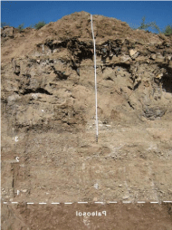
    Figure 5:  Well-2 opened on Iluh creek bed. Numbers 1, 2 and 3 shows
different flood events.
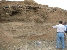
    Figure 6:  In the log well-2, it is possible to see layers together comprising
of gravels, silt and fine sand which reflect different flood periods. The gravel
sizes decreasing from down to top indicate that the energy of floods has
reduced from past to present.
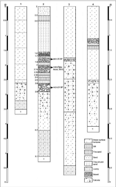
    Figure 7:  The stratigraphy of log wells (with scale). Layers associated with
paleofloods were also observed in four log wells opened at different points
of the bed of Iluh Creek. Of them, the most ideal section reflecting the floods
which occurred in the last 1500 years was observed in the log well-2.
The size of gravels, sand and loam particles increased with depth. This is most probably due to decrease of flood energy in time. Moreover, the presence of shards and bones suggest effect of recent floods on rural settlements. Sediment features in Well 3 opened on the west of Well-2 was quite different because the creek bed of Iluh was changed by humans. Thus, deposits at 160-290cm in Well-2 were not determined in Well-3 (Figure 7).
Gravelly transition and relatively low gravel containing brown soil layer observed at 175-185cm was equal to gravel bar of Well-2 at 260-290cm.
Well-4 was opened at northwest of Well-2 in cultivated field which represent similar features such as flood deposits to Well-2 (Figure 7). Deposits at 110-135cm and 250-260 revealed the last and first flood events in the past.
Shards collected from Well-2 were analyzed by thermoluminescence and 14C in University of Çukurova, Department of Archaeometry, Adana Turkey and Germany respectively.
Thermoluminescence (TL) analyses
Shards collected from Well-2 at 170-190, 200-215 and 260- 290cm depths were analyzed for their exposure to sunlight since no dosimeter was installed at site. Pottery is produced more than 800°C which empties trapped electrons from the minerals and following firing traps are again filled with environmental radiation [33]. Thus, exposure to sunlight or heat from a fire at a site of human occupation empties many of the traps in minerals of the shards. This well-known phenomenon is used for comparing shards exposure to sunlight to determine exposure period after flood event which also reveals frequency of floods [35,39,40]. Thus, low TL peaks showed longer exposure since sun light empties electrons from mineral traps [33].
The TL glow of 290-260cm shards with porous, unglazed with nonuniform firing pattern, suggests a relatively low period of exposure (Figure 8). Coarse gravel bars and rock fragments revealed high transportation energy [41]. The exposure of 200-215cm shard samples with fine slip relatively higher than 260-290cm samples however 170-190cm sample documented the highest exposure period (Figure 8, 9, 10, 11).
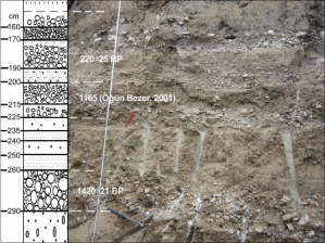
    Figure 8:  Sampling points at Well-2. Gritty layers show different flood periods
and the pottery pieces were found in these layers. The layers which are 20-
30 cm thick are separated from each other with layers formed with yellowish
fine sand.
The medium to fine gravels of the section suggests a moderate transportation energy (grading and sorting) (Figure 7) [42]. Thus, shards at 215-200cm were most probably transported with moderate energy and exposed to sun light longer than 290cm samples. Samples of 190-170 cm glazed with uniform firing pattern have the highest glow (Figure 9, 10, 11). Moreover, grading and sorting of the materials in the layer finer than former two layers revealed low energy of the creek transportation (Figure 7).
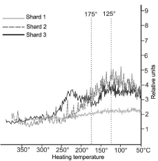
    Figure 9:  TL analysis results of shards collected from gravelly layer at 260-
290cm depths in the log well-2.
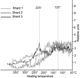
    Figure 10:  TL analysis results of shards collected from the layer at 200-
215cm depths in the log well-2.
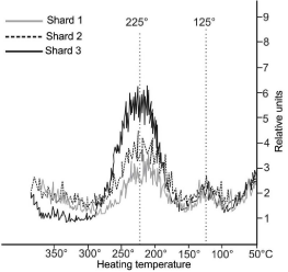
    Figure 11:  TL analysis results of shards collected from the layer at 170-
190cm depths in the log well-2.
14C Analyses
Dating error may vary from 4 to 160 years in radiocarbon analyses [43]. However, dating error in this study was 25 years and it is within the 25 to 50 years of acceptable error range which was suggested by Benitto and Thorndycraft (2005) [32] for the last millennium flood deposits. 14C analyses were performed in Heidelberger Academy of Science (Germany) only at Well-2 samples of human and animal bones that are suitable for 14C analyses (Table 1).
    Lab. No
    Sample Label and dept
    Mean date 14C    BP
    ?13C
    Calibrated age 1?


    Calibrated age ???


    Hd-27943
    II-1. 170-190 cm
    220±25
    -29.4
    cal AD 1650- 1950
    cal AD 1644- 1951


    Hd-27944
    II-4. 260-290 cm
    1420±21
    -18.8
    cal AD 618- 649
    cal AD 600- 656


    Note: Calibrated with INTCAL04 and    CALIB5 [55].
Table 1: 14C Analyses of Well-2 samples (09.04.09) (09.04.09).
14C dating revealed severe flood events 1420±21 years before present in Batman. Fine sand and loamy bar deposited on gravelly layer manifested a more humid and high rainfall period. Last severe flood occurred 220±25 years before present. Latter flood deposited relatively finer material than the first flood which most probably showed low transportation energy. Another flood event was observed between these two events however, due to lack of available sample for 14C analyses dating was not employed for this layer. However, it was stated in the study of Öğün Bezer (2001) [44] that there had been a big flood around Batman in 19 May 1165, which was mentioned in historical sources. When radiocarbon age data and this date are compared, it is found that the second food occurred 800 years ago. Therefore, it has become possible to determine accurately the floods which occurred in the past 1500 years around Batman.
Historical and geoarchaeological findings
It is of utmost importance to know the characteristics of flood and torrent events experienced in the past to forecast the behaviors of probable floods and torrents in the future. In this respect, in flood and torrent studies, it is necessary to review the floods in paleo or historical periods. Historical records on floods are not available in Batman due to its recent approval as a city in 1940. However, damages seen in rural settlements on Batman riverbanks suggest frequent flood occurrence in the past. The largest flood known to have occurred in Batman and its vicinity dates back to May 19, 1165. 160 people died in this disaster [44]. The second largest hazardous flood recorded occurred in El Medina located on flood plain of Batman river in 1926 [45] and repeated floods wiped out the town (Figure 12).
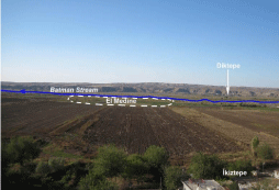
    Figure 12:  The site of El Medina settlement, founded in flood plain of Batman
river, and wiped off in 1926 flood.
The foundation date of El Medina is not exactly known; however, as recorded in 1899 yearbook, it is a settlement comprising of 128 houses within the administrative organization of Diyarbakir Province [46]. The fact that the last important flood occurred 220±25 years ago according to radiocarbon dating indicates that El Medina was founded in the early 1800s after this flood.
It is very difficult to obtain historical documents related to previous floods in the areas other than large centers of Turkey. Nevertheless, in the studies carried out along the valleys of the Euphrates and Tigris rivers, significant findings were obtained in relation to floods that occurred in historical periods in the Southern Anatolia Region [47- 50] (Figure 13). Undoubtedly, it is considered that the floods in the upper basins of the Euphrates and Tigris rivers also had an effect in the lower basins. Archeological excavations carried out in the mounds along the valleys of the Euphrates and Tigris Rivers provide reliable data about the floods occurred within the years 4000-5000 years, 1500 years before today (Table 2).
    Stream-Region
    Location (Mound-Historical Settlement)
    Period
    Date
    Source


      Tigris River
    Kortik Tepe (Bismil/Diyarbakir)
    Aceramic Neolithic
    Before 6000BC
    Doğan [50]


    KavuŞan Tepe (Bismil/Diyarbakir)
    Late Chalcolithic-Early Bronze Age
    3000-2000 BC
    Doğan [50]


    AŞaği Salat Tepe (Bismil/Diyarbakir)
    Early Bronze Age I
      Early Bronze Age-Iron Age
      Middle Age and Today
    2800-2650 BC
      2650-1200 BC
      500 AC-After
    Doğan [50]


    Euphrates River
    Değirmentepe (Kale/Malatya)
    Early Bronze Age I-Iron Age
    3000-1000 BC
    Esin [56]; Köroğlu [48]


    KöŞkerbaba (Kale/Malatya)
    Early Bronze Age-Iron Age
    2650-1200
    Bilgi [60]; Köroğlu [48]


    İmikuŞaği (Baskil/Elaziğ)
    Late Bronze Age
    2000-1500 BC
    Sevin [59]; Köroğlu [48]


    Kösehöyük (Malatya) and Kaleköy (Elaziğ)
    Early Bronze Age-Iron Age
    2650-1200
    Özdoğan [58]; Köroğlu [48]


    Southern
      Mesopotamia
    Ur City
    Late Chalcolithic- (Ubaid Period)

    3500 BC
    Wolley [57]; Köroğlu [48]


    Ur City
    Early Bronze Age I (Early Dynasties I and II)
    2700 BC
    Köroğlu [48]


    KiŞ Province
    Early Bronze Age I (Early Dynasties I and III)
    2900 BC
      2600 BC
    Köroğlu [48]; Doğan [50]


    Tell ed-Der (South of Baghdad)

      Late Bronze Age

    1830-1770 BC
      1770-1700 BC
      1700-1650 BC
      1650-1500 BC
    Köroğlu [48]
Table 2:  Paleofloods and their occurrence periods according to archeological excavations carried out in the historical settlements located in the valleys of Upper
Euphrates and Tigris rivers and Southern Mesopotamia.
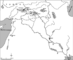
    Figure 13:  Historical settlements located in the upper and lower basins of the
Euphrates and Tigris rivers and affected by the flood.
In the archaeological excavations on the historical settlements which were submerged under the waters of the dam constructed on Euphrates and Tigris rivers, important flood data of historical periods were reached. Most of the archaeological excavations in Tigris River Valley were done in the mounds very near to Batman (Figure 13). So, geoarchaeological data provide considerably tangible results about the paleoflood in the territory.
Batman became a province through development as a result of rapid urbanization movements in the last 50 years. There was once a small village settlement in the foundation area of the city. In addition, Körtik Tepe located on the junction of Tigris river and Batman Stream in the southeastern part of Batman city was founded in the Aceramic Neolithic (10500?BC) period [51]. The existence of dense historical settlements in the valley of Tigris River and Batman Stream indicates that the district has been an area of settlement since the early periods of history.
In archeological excavations carried out in Tigris Valley between Bismil (Diyarbakir) and Batman, significant changes were obvious in the natural environment conditions of the district in the Holocene Period [49,50]. According to geoarchaeological data obtained through studies conducted in historical settlements located on the terraces of Tigris River between Bismil and Batman, this site has been an area of settlement since the Neolithic period. The settlements founded on the terraces of Tigris River were affected by floods in certain periods (Table 3). Accumulation occurred during the periods of large floods and incision occurred in the interim periods.
    Periods
    Sediment Accumulation or    Incision


    Early Neolithic (before 6000 BC)
    Accumulation


    Late Neolithic (6000-5500 BC)
    Incision


    Early Chalcolithic (5500-4000 BC)
    Accumulation


    Late Chalcolithic-Early Bronze Age (4000-2650 BC)
    Incision


    Early Bronze Age-Iron Age? (2650-1200 BC)
    Accumulation


    Iron Age-First and Middle Age (1200 BC-637 AC)
    Incision


    Middle Ages and Modern Age (637AC-1800 AC)
    Accumulation


    Modern Age (1800 AC    after )
    Incision
Table 3:  Accumulation and Incision Periods around Tigris River and Batman
Stream between Bismil and Batman According to Archeological and Radiocarbon
Dating Data.
The classification of Doğan [50] covering the periods up to Iron Age was used for the separating of accumulation and incision periods and these periods from that time to present were determined in accordance with sedimentological analyses which we performed on the fan formed by Iluh Creek. Flood data within the archaeological excavations generally belong to the period 1500-2000 years before today. Flood periods in the last 1500 years period which was missing have been determined in this study. In conclusion, geoarchaeological findings and age results of this study have been combined and the paleofloods which have occured in the last 6000 years period around Batman have been determined.
Results and Discussion
The most accurate paleoflood techniques are based on the determination of higher stream levels and paleostage indicators [32]. In paleoflood studies, paleostage indicators other than slack water deposits are also used [52]. Therefore, the presence of slack water deposits is not a necessity in paleoflood studies. Paleoflood studies are generally carried out in a stream valley where frequent flood events occur. Our study was also conducted according to sedimentological data obtained from the area of İluh Creek Valley where flood events occur frequently (Figure 3). The existing findings were compared with geoarchaeological data and thus the floods occurred around Batman within the last 1500 years period were determined (Table 1, 3).
Only limited number of log wells could be opened as a major part of the fan formed by Iluh Creek was occupied by the settlements. Nevertheless, reliable results were obtained from four log wells opened. Gravelly levels in the alluvial fans indicate high energy periods of streams. For seasonal streams with a wide basin like Iluh Creek, gravelly levels also correspond to flood periods. The section no 2 in the log wells opened in the part of Iluh Creek at the exit of Batman city has such a structure. At this section, gravelly layers as well as fine sand and silt layers exist.
As Batman city has an ancient history of settlement, many shards carried by floods were found in the log wells. It is not always possible to see such materials by the streams. As no measurement with dosimeter was possibly made in the terrain, the age of shards could not be determined. The material was analyzed using Thermoluminescence method in order to reveal the intensity of flood. Other than historical evidences, bone parts carried certainly by floods were subject to radiocarbon dating (14C) process. As radiocarbon dating is a standard process in paleoflood investigations, it was also employed in this study [37,38]. When these data and climate and vegetation records of the region covering a period of the last 1500 years were compared, the existing dating was proved to be true (Figure 14).
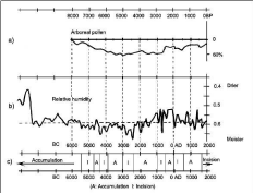
    Figure 14:  A comparison of accumulation and incision periods with arboreal
pollen and atmospheric humidity in the Southern Anatolia Region. a) Arboreal
pollen from Söğütlü, Lake Van (based on Bottema, 1995 [53]); b) Proxy
humidity curve (from Lemcke and Sturm, 1997 [54]); c) Accumulation and
incision periods seen within the last six-seven thousand years. In the flood
periods, accumulation occurred, and in the following periods, incision events
occurred. This event demonstrates compatibility with the arid and humid
periods above.
The results obtained by means of arboreal pollen analyses applied to the surroundings of Lake Van and geochemical analyses on the sediments of Lake Van may also possibly by used to explore the floods experienced in the valleys of the Euphrates and Tigris rivers. Even though Lake Van is remote to the Southern Anatolia Region and exhibits different climatic characteristics, it has similar features to the upper basins of the Euphrates and Tigris rivers. In this respect, pollen and paleoclimate data obtained for the surroundings of Lake Van [53,54] may be used as a reference for the parts of the Euphrates and Tigris rivers involved in the boundaries of Turkey. This reference is especially more suitable for flood studies. As a matter of fact, the periods when arboreal pollens decrease correspond to arid and incision periods, while the periods when they increase correspond to humid and accumulation periods. This situation has been more clearly observed in the last 1500 years (Figure 14).
In the study on geochemistry of the sediments of Lake Van [54], a very close association was found between paleoflood analyses for Iluh Creek and the periods of humidity and aridity in the last 1500 years. According to sedimentological analyses, 3 large flood events were recorded around Batman. According to 14C BP dating, the first flood dates back to 1420±21 years BP and the third one dates back to 220±25 years BP. The period of the second flood between these two flood periods was aged according to historical data and it was seen 800 years before today. According to historical data, the flood and torrent events experienced in Batman region on May 19, 1165 [44] correspond to the above mentioned second flood. The periods of aridity in the last 1500 years around Lake Van and the periods of flood around Batman correspond to the same dates. In the geochemical analyses of the sediments of Lake Van, the periods of aridity in 1400, 800 and 200 years before present correspond to the periods of flood around Batman. All these data confirm the accuracy of pollen, sediment and 14C BP dating.
In conclusion, pollen and geochemical analyses applied around Lake Van, geoarchaeological studies conducted in the valleys of the Euphrates and Tigris Rivers, the historical data and our analyses indicate the existence of a period of 1000 to 1200 years between the accumulation and incision periods throughout the Holocene period around Batman and across the entire Southeastern Anatolia Region.
Acknowledgement
This project was funded by the Turkish Scientific and Technical Research Council (TüBİTAK) project No. 107Y072. We extend our thanks to Mr. Bernd KROMER from Heidelberger Academy of Sciences for undertaking radiocarbon analyses.
References
- KoÇman A, Kayan İ. at al. İzmir’de 3-4 Kasim 1995 KarŞiyaka Sel Felaketi (OluŞumu, GeliŞimi, Etkileri ve Alinmasi Gereken önlemler), Ege üniversitesi İzmir AraŞtirma ve Uygulama Merkezi Yayinlari No: 1, İzmir. 1996.
- Uzun A. Erzurum Çevresindeki Sellere Bir örnek: 16 Ağustos 1994, Rizekent Seli, OMü Eğitim Fakültesi Dergisi,1995: 246-260.
- SelÇuk Biricik A. Flood Disasters in Senirkent (13 July 1995-18, 19 July 1996), Marmara Geographical Journal. 1997; 9-30.
- Buldur AD, Pinar A, BaŞaran A. 05-07 Mart 2004 Tarihli Göksu Nehri TaŞkini ve Silifke’ye Etkisi, SelÇuk üniversitesi Sosyal Bilimler Enstitüsü Dergisi. 2007; 139-160.
- Şahinalp M. Neden ve SonuÇlariyla Şanliurfa İlinde YaŞanan Sel Felaketleri (28, 29 Ekim, 1 Kasim 2006), Türk Coğrafya Dergisi. 2007; 89-122.
- Ecer R, Yenigün K. Gap Bölgesi’nde Kentsel Altyapinin Bir TaŞkin örneğinde Değerlendirilmesi; Nedenler ve öneriler, TMMOB Afet Sempozyumu. 2007; 185-200.
- Sezen N, Gündüz N, Malkarali S. Meric River Floods and Turkish-Bulgarian Cooperations, İnternational Congres on River Basin Management. 2007; 646-654.
- Türkoğlu N. Güneydoğu Anadolu Bölgesinde 31 Ekim-1 Kasim Tarihlerinde Meydan Gelen TaŞkinlarin Analizi, e-Journal of New World Sciences Academy Social Sciences. 2009; 4: 243-254.
- Kochel RC, Baker VR, Patton PC. Paleohydrology of Southwestern Texas. Water Resources Research.1982; 18: 1165-1183.
- Ely LL, Baker VR. Reconstructing paleoflood hydrology with slackwater deposits: Verde River, Arizona. Physical Geography. 1985; 6: 103-126.
- O’Connor JE, Ely LL, Stevens LE, Melis TS, Kale VS, Baker VR. A 4500-year record of large floods in the Colorado River in the Grand Canyon, Arizona. Journal of Geology. 1994; 102: 1-9.
- Carson EC. Hydrologic modeling of flood conveyance and impacts of historic overbank sedimentation on West Fork Black’ Fork, Uinta Mountains, Norteast Utah, USA, Geomorphology. 2006; 75: 368-383.
- Baker VR, Pickup G. Flood geomorphology of the Katherine Gorge, Northern Territory, Australia. Geological Society of America Bulletin. 1987; 98: 635-646.
- Pickup G, Allan G, Baker VR. History, palaeochannels and palaeofloods of the Finke River, central Australia. Warner RF, editor. In: Fluvial Geomorphology of Australia. Academic Press, Sydney. 1988; 177-200.
- Ely LL, Enzel Y, Baker VR, Kale VS, Mishra S. Changes in the magnitude and frequency of Holocene monsoon floods on the Narmada River, Central India. Bulletin of the Geological Society of America. 1996; 108: 1134-1148.
- Kale VS, Singhvi AK, Mishra PK, Banerjee D. Sedimentary records and luminescence chronology of Late Holocene palaeofloods in the Luni River, Thar Desert, northwest India. Catena. 2000; 40: 337-358.
- Benito G, Sopena A, Sanchez Y, Machado MJ, Perez Gonzalez A. Palaeoflood record of the Tagus river (Central Spain) during the Late Pleistocene and Holocene. Quaternary Science Reviews 22,2003; 1737–1756.
- Thorndycraft VR, Benito G, Rico M, Sanchez-Moya Y, Sopena A, Casas A. A long-term flood discharge ecord derived from slackwater flood deposits of the Llobregat River, NE Spain. Journal of Hydrology. 2005; 313: 16-31.
- Thorndycraft VR, Benito G. The Holocene fluvial chronology of Spain: evidence from a newly compiled radiocarbon database. Quaternary Science Reviews. 2006; 25: 223-234.
- Thorndycraft VR, Benito G. Late Hotocene fluvial chronology in Spain: the role of climatic variability and human impact. Catena. 2006; 66: 34-41.
- Sheffer NA, Enzel Y, Benito G, Grodek T, Porat N, Lang M, et al. Paleofloods and historical floods of the Ardecha River, France. Water Resources Resarch. 2003; 39: 1376.
- Sheffer NA, Rico M, Enzel Y, Benito G, Grodek T. The Paleoflood record of the Gardon River, France: A comparison with the extreme 2002 flood event. Geomorphology. 2008; 98: 71-83.
- Woodward JC, Hamlin RHB, Macklin MG, Karkanas P, Kotjabopoulou P. Quantitative sourcing of slackwater deposits at Boila rockshelter: a record of late-glacial flooding and Palaeolithic settlements in the Pindus Mountains, Northern Greece. Geoarchaeology. 2001; 16: 501-536.
- Zawada PK. Palaeoflood hydrology: method and application in flood-prone southern Africa. South African Journal of Science. 1997; 93: 111-131.
- Yang H, Yu G, Xie Y, Zhan D, Li Z. Sedimentary records of large Holocene floods from the middle reaches of the Yellow River, China. Geomorphology. 2000; 33: 73-88.
- Jones AP, Shimazu H, Oguchi T, Okuno M, Tokutake M. Late Holocene slackwater deposits on the Nakagawa River, Tochigi Prefecture, Japan. Geomorphology. 2001; 39: 39-51.
- Petrucci O, Polemio M. The role of meteorological and climations in the occurrence of damaging hydro-geologic events in Southern Italy. Natural Hazards and Earth System Science. 2009; 9: 105-118.
- Sunkar M, Tonbul S. Effect of Changes in Geomorphological Units on Flood and Torrent Events due to Rapid Urbanization in Batman. e-Journal of New World Sciences Academy, Nature Sciences. 2011; 6: 1-29.
- Sunkar M , Tonbul S. Effect of meteorological events on flood occurrence in Batman, Turkey, Journal of Environmental Hydrology. 2011; 19.
- Sunkar M, Tonbul S. Effect of Human Factors on Occurrence of Flood and Torrent Events in Batman, Southeastern Turkey, Electronic Journal of Social Sciences. 2011; 10: 267-292.
- Sunkar M, Tonbul S. Hydrographic analysis of Iluh River (Batman) in relation to flood and torrent events. ELSEVIER Procedia - Social and Behavioral Sciences. 2011; 19: 537-546.
- Benitto G, Thorndycraft VR. Paleoflood hydrology ant its role in applied hydrological sciences, Journal of Hydrology.2005; 313: 3-15.
- Aitken MJ. An Introduction to Optical Dating. Oxford University Press, Oxford. 1998; 280.
- Bluszcz A. Simultaneous OSL and TL Dating of Sediments, Quaternary Science Reviews. Elsevier. 2001; 20: 761-766.
- ögelman GY, Kapur S. Thermoluminescence reveals weathering stages in basaltic rocks. Nature. 1982; 296: 231-232.
- Zimmerman DW. Thermoluminescent Dating Using Fine Grains from Pottery. Archaeometry. 1971; 13: 29-52.
- Baker VR, Kochel RC, Patton PC, Pickup G. Paleohydrologic analysis of Holocene flood slack-water sediments, International Association of Sedimentologists.1983; 6: 229-239.
- Baker VR, Pickup G, Polach HA. Radiocarbon dating of flood events, Katherine Gorge, Northern Territory, Australia. Geology. 1985; 13: 344-347.
- Yeğingil Z, Kapur S. Adana yöresine (Türkiye'nin güneyi) ait seramiklerin TL tarihlendirmesi ve isitilma sicakliklarinin belirlenmesi. Arkeometri ünitesi Bilimsel Toplanti Bildirileri VI, 15-17 Mayis, İstanbul. 1985.
- AkÇa E, Kapur S, özdöl S, Hodder I, Poblome J, Arocena J, et al.. Clues of production for the Neolithic Çatalhöyük (central Anatolia) pottery, Scientific Research and Essays. 2009; 4: 612-625.
- Dietrich WE, Day G, Parker G. The Fly River, Papua New Guinea: inferences about river dynamics, floodplain sedimentation and fate of sediment. A. J. Miller, A. Gupta, editors. In: Varieties of Fluvial Form. John Wiley& Sons, Chichester, UK. 1999; 345–376.
- Pettijohn FJ, Potter PE, Siever R. Sand and Sandstone, Springer & Verlag, Berlin. 1987; 553.
- Trumbore SE. Constraints on below-ground carbon cycling from radiocarbon: the age of soil organic matter and respired CO2, Ecological Applications. 2000; 10: 399-411.
- öğün Bezer G. Selçuklular Zamaninda Anadolu’da ve Civar Bölgelerde Kitlik, Tarih Boyunca Anadolu’da Doğal Afetler ve Deprem Semineri, Bildiriler Kitabi, İstanbul. 2000; 67-83.
- Zengin B. GeçmiŞten Günümüze Batman, Batman Kültür ve Sanat Derneği, Matris Matbaacilik. 2005.
- Acar A. EL-Medine: Batman Suyu’nun Tarihten Sildiği Şehir, 1st International Symposium on the History and Culture of Batman and its Vicinity, Proceedings I, pp. 297-309, 15-17 April 2008. Batman / Turkey, 2008.
- Wilkinson TJ. Holocene valley fills of Southern Turkey and Northwestern Syria: recent geoarchaeological contributions. Quaternary Science Reviews. 1999; 18: 555-571.
- Köroğlu K. Firat Havzasinda Tufani Animsatan Sel Baskinlari. Toplumsal Tarih, 2001; 7: 26–31.
- Kuzucuoğlu C. Preliminary observation on the Tigris Valley terraces between Bismil and Batman. Tuna, N., editors. In: Salvage Project of the Archaeological Heritage of the Ilisu-Carchemish Dam Reservoirs Activities in 2000. METU, Ankara. 2002; 759–771.
- Doğan U. Holocene fluvial development of the Upper Tigris Valley (Southeastern Turkey) as documented by archaeological data, Quaternary International. 2005; 129: 75-86.
- Özkaya V, San O. KÖrtik Tepe 2001 Kazisi, 24. Kazi Sonuçlari Toplantisi. Doğan, U, editors. In: Holocene fluvial development of the Upper Tigris Valley (Southeastern Turkey) as documented by archaeological data, Quaternary International. 2004.
- Baker VR. Paleoflood hydrology: Orgin, progress, prospect. Geomorphology. 2008; 101: 1-13.
- Bottema S. Holocene vegetation of the Van area: Palynological and chronological evidence from SoÖğütlü. Wilkinson, T.J. editors, In: Holocene valley fills of Southern Turkey and Northwestern Syria: recent geoarchaeological contributions. Vegetation History and Archaeobotany. 1995; 4187-193.
- Lemcke G, Sturm M. ?18O and trace element measurements as proxy for the reconstruction of climate changes at Lake Van (Turkey): Preliminary results. Wilkinson, T.J, editors. In: Holocene valley fills of Southern Turkey and Northwestern Syria: recent geoarchaeological contributions, 1999. NATO ASI Series. 1997; 49: 653-678.
- Reimer PJ, Baillie MGL, Bard E, Bayliss A, Beck JW, Bertrand CJH, et al. IntCal04 Terrestrial Radiocarbon Age Calibration, 0-26 Cal Kyr BP. Radiocarbon. 2004; 46: 1029-1058.
- Esin U. Değirmentepe Excavation, 1979, Lower Euphrates Project, 1978-1979 Activities, Ankara. 1987; 89-101.
- Wolley CL. Excavations at Ur, (New York), In: KÖroğlu, K., 2001. Deluge-like Floods in the Euphrates Basin. Social History. 1954.
- Özdoğan M. AŞaği Firat Havzasi 1977 Yüzey AraŞtirmalari, (İstanbul), In: Köroğlu, K., 2001. Firat Havzasinda Tufani Animsatan Sel Baskinlari. Toplumsal Tarih. 1977.
- Sevin V. İmikuŞaği I, (6.-1. Yapi Katlari), Ankara, In: Köroğlu, K., 2001. Firat Havzasinda Tufani Animsatan Sel Baskinlari. Toplumsal Tarih. 1995.
- Bilgi ö. KöŞkerbaba Mound Excavation, Lower Euphrates Project, 1978-1979 Activities, Ankara.1987; 189-201.