
Research Article
Austin J Hydrol. 2015; 2(1): 1016.
Environmental Situation of Vlora Bay, Albania Based on Physico-Chemical Parameters of Seawater
Kane S¹, Qarri F¹ and Lazo P²*
¹Department of Chemistry, University of Vlora “Ismail Qemali”, Albania
²Department of Chemistry, University of Tirana, Albania
*Corresponding author: Lazo P, Department of Chemistry, Faculty of Natural Sciences, University of Tirana, Tirana, Albania
Received: November 03, 2015; Accepted: December 10, 2015; Published: December 16, 2015
Abstract
Vlora Bay is one of the most attractive coastal zones of Albania, defined as a top-priority tourism area. It presents quite suitable conditions to accommodate vessels of various types. Human activities around Vlora Bay and port areas cause significant water pollution. Industrial wastewater and urban water overflow are traditional pollution sources of this area. This study was carried out to evaluate the environmental status and to assess the pollution level of Vlora bay. Two main ports, the Commercial Port and Fishing Ports, that are positioned in the bay, are subject to various and potential pollutants, i.e. boat and ship antifoulants, boat hull cleaning, oil and other releases and discharges from boats, wastewater discharges from municipalities and industrial facilities etc. In order to assess the water quality of Vlora Bay, water samples were collected from fourteen sampling sites (including the Commercial & Fishing Port, Vlora Bay and Narta and Orikumi Lagoon) and physico-chemical parameters of water such as temperature, pH, Dissolved Oxygen (DO), Biological Oxygen Demand (BOD), particulate material (TSS and TDS), nutrients (N-NO2 -, N-NO3 -, N-NH4 +, P-PO4 3-) were determined. Based on the results of physico-chemical parameters and nutrients content in the studied areas it was found that nutrients content was found at higher concentrations in both ports compared to the bay, but they were within the permitted levels of Seawater Quality.
Keywords: Vlora bay; Ports; Seawater quality; Pollution effect; Physicochemical parameters; Nutrients; Cluster analysis
Abbreviations
DO: Dissolved Oxygen; BOD: biological oxygen demand; TSS: Total Suspended Solids; TDS: Total Dissolved Solids; E: Redox potential; PET bottles: Polyethylene Terephthalate Bottles; CA: Cluster analysis.
Introduction
Water is the most important natural resource in the world [1]. The composition of seawater is important for the suitability of aquatic life. The climate change as well as the urban and industrial development cause severe threats to seawater integrity and sustainability. The chemical, physical and biological processes occurring in coastal zones can modify the marine ecosystem conditions [2]. The natural composition of the waters could be affected by human pollution through water discharges from the surrounding areas [3]. Coastal areas today have become collectors of all urban and industrial discharges, in this context is included also Vlora`s seacoast [4]. Marine ports are significant hubs of economic activity and major sources of pollution [5,6]. Their waters are subject to a variety of potential pollutant sources including boat and ship antifoulants, boat hull cleaning, and other releases and discharges from boats, wastewater discharges from municipalities and industrial facilities, storm water runoff from municipal, industrial (including shipyards) and agricultural activities, groundwater and the atmosphere. These sources of potential pollutants can degrade the water quality, beneficial uses of the waters through causing aquatic life toxicity and excessive food web bioaccumulation, as well as causing other impairments of the water body’s beneficial uses [7]. Multiple contaminants from ports disperse in the surrounding water basins and may seriously affect the condition of river and sea water ecosystems every port is distinguished for specific natural and anthropogenic factors responsible for water contamination levels, spectrum of pollutants, and dynamic patterns [6,8,9].
Vlora Bay is one of the most attractive coastal zones of Albania, and it has been defined as a top-priority tourism area It is located in southern Albania, at the intersection of the Adriatic and Ionian seas. It is a semi-closed bay and has restricted water exchange with the Adriatic Sea throughout the mezocanal inlet. Unfortunately, the area has suffered from significant population growth and increase in human activities in recent years [10]. Vlora Bay presents quite suitable conditions to accommodate vessels of various types. Two of the most important ports of Vlora city, used for this purpose, are the Commercial Port and Fishing Port (Triport). Human activities around port areas cause significant water pollution. Industrial wastewater and urban water overflow are traditional pollution sources in port areas [11]. Water exchange in bays is often limited and shipping activities introduce contaminants, which include oil, trace metals, nutrients and organochlorine compounds [12]. In addition, during the period of port operation, routine pollution from ships - oil, litter, gaseous air pollutants, dust, hazardous materials etc. are often significant [11]. One of the most common causes of water pollution in harbours is the dumping of untreated sewage. Close to the anchor gate of commercial port, the untreated urban wastes of Skela area are discharged through a collector directly into the sea. Beside it, these wastes can cause an increase in the content of inorganic compounds of nitrogen and phosphorus. When a water body is overloaded with nitrogen and phosphorus, a process of euthrophication can rapidly increase and become a serious pollution problem [6]. Finally, the natural composition of the waters in ports could be affected by the wastes discharged from transport ships and ferry anchored in the commercial port of Vlora or fishing vessels in Fishing Port (Triport).
The present paper aims at assessing the quality of seawater in the Commercial Port and Fishing Port, Vlora, Albania. A single expedition to collect water samples in these ports was carried out and seawater quality assessment was based on the physico-chemical parameters of water such as temperature, pH, Dissolved Oxygen (DO), Biological Oxygen Demand (BOD), particulate material (TSS and TDS), nutrients (N-NO2 -, N-NO3 -, N-NH4 +, P-PO4 3-).
Materials and Methods
Studied area
Vlora, with approx. 100,000 inhabitants, is situated at Vlora Bay that is considered as the frontier between the Adriatic and Ion Sea. The Sazani Island is positioned at the entrance of Vlora Bay causing unfavorable condition of water circulation between the bay and open sea. The distance of Vlora Bay from Italy is 70 nautical miles. The hills around the town are cultivated with olive groves. Vlora Bay presents quite suitable conditions to accommodate vessels of various types. Two of the most important ports of Vlora city are the Commercial Port and Fishing Port (Triport). Harbour activity can cause significant damage to water quality and subsequently to marine life and ecosystems, as well as to human health.
The Commercial Port of Vlora is the second port in importance (after port of Durrës), for the severity of capacity, and the largest port of South Albania serving for the transport of goods and passengers. The harbor size is very small (coastal type gate) and the maximum vessel size is up to 500 feet in length. The water depth varies from 4.9 - 6.1 m of cargo pier, 9.4 - 10 m in the channel and oil terminal and 17.1 - 18.2 m in anchorage. For the features it is a straightforward port consisting of two major moths, holding vessels such as cargo ship and ferries. There are no strong currents and fluctuations that may affect navigation tools, so it can ensure a safe mooring beside him, outside the system of quays and a place that protects ships thanks to its geographical position.
The Fishing Port known as “Triport” is situated in the north-west of the Commercial port of Vlora. This port is mainly used for the anchor of fishing vessels.
Sampling sites
Sampling sites are shown in (Figure 1). One water sample (St. 14), collected 800 m from the Karaburuni shore, and was selected as a reference station with low anthropogenic inputs.
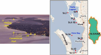
Figure 1: The map of sampling stations.
Samples were collected during May 2014, 50 cm deep and 50- 100 m from the shore. Sample stations were chosen carefully in order to assess the level of the water contamination and to evaluate the possible polluting sources of these two port areas and Vlora bay. Sample collection, transport and conservation were in line with recommendations made by APHA [13].
Water samples were collected in 1.5 liter PET bottles and transported on the same day to the laboratory using refrigerated containers stored below 4°C. Once transported to the laboratory, physico-chemical parameters of water were determined. Surface water temperature, pH and red/ox potential were measured using a pH meter (Model pHS-3BW). Electrical Conductivity (EC) and Total Dissolved Solids (TDS) were measured using a conduct meter (Model DDSJ 308A). Winkler method was used for the determination of the concentration of Dissolved Oxygen (DO) and Biological Oxygen Demand (BOD) content. Total Suspended Mater (TSS) was determined by pouring one litre volume of water through a preweighed filter of 0.42 μm pore size, and weighing the filter again after drying it at 105oC for 2 hours to remove all the water. Nutrients (NNO3-, N-NO2-, N-NH4+, P-PO43-) content was determined according to the APHA [13] using UV 2401 PC, spectrophotometer for nitrogen compounds and PYEUNICAM SP-9 spectrophotometer for phosphate determination.
Statistical analysis of the data
Aiming to explain the variations of the data and to interpret the results, the descriptive statistics were applied to the data set of all parameters. The Pearson correlation coefficient (r2) was used to determine the strength of the association between two normal distributed variables that may indicate that the variables do indeed affect to each other. Finally, the data were processed with Cluster analysis (CA). Cluster analysis was used to detect the parameters with similar patterns and high correlation in the same groups. The numbers of the groups are discussed based on environmental effect of the parameters and their chemical and physical properties. MINTAB 17 software package was used for statistical analysis of the data.
Results and Discussion
Diagrams in (Figure 2,3) plot the physico-chemical parameters of water in the Commercial & Fishing ports and other areas of Vlora Bay.
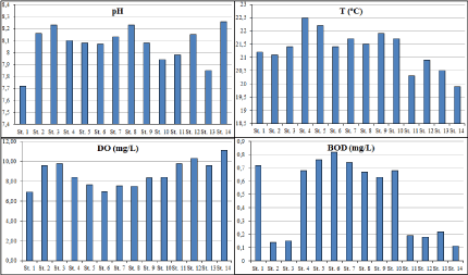
Figure 2: a) pH, b) temperature, c) dissolved oxygen, d) biological oxygen demand content in water of Commercial & Fishing port and other sites of Vlora Bay.
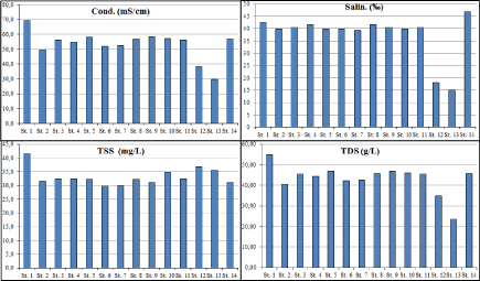
Figure 3: a) Conductivity, b) salinity, c) TSS, c) TDS content in water of Commercial & Fishing port and other sites of Vlora Bay.
pH
pH of aquatic ecosystems depends on the chemical and biological activity of water. Changes in pH can be indicating the presence of industrial pollutants, photosynthesis or the respiration of algae that are feeding with the contaminants. Most ecosystems are sensitive to the changes in pH and the monitoring of pH has been incorporated into the environmental laws of most industrialized countries [14]. As we can see from (Figure 2/a), pH values fluctuated between 7.72 - 8.26 at station St. 1 (Narta Lagoon) and at station St. 14 (reference station, Figure 1: The map of sampling stations. Orikum) respectively. Lower pH values resulted in all water samples compared to the reference sample due to the urban wastes and the limited water circulation.
Temperature
The water temperature is the best index of seasonal fluctuations [15]. It is affected by several factors including weather conditions, removal of shading stream bank vegetation and storm water. As it would be expected, the temperature of surface water of two ports and the other studied areas of Vlora Bay fluctuated between 19.9 to 22.5°C with a mean value of 21.3°C that is normal for the period of sampling process (during May).
Dissolved oxygen
Dissolved Oxygen (DO) is an important environmental parameter needed for a good quality of surface water. In general, it is available as dissolved state at water bodies [16]. The fluctuations in the dissolved oxygen levels in water can be caused by aquatic vegetation and anthropogenic status of the water. It is well known that the temperature and salinity affect the dissolution of oxygen in water [17]. DO in water originate from the air dissolution and the process of photosynthesis that occurs during daylight. At high temperature, which is usually observed in dry season, the solubility of oxygen decreases while at lower temperature (wet season) it increases [18,19].
As it can be seen from the (Figure 2c) the quantity of DO in water of two ports and other surrounded areas in Vlora Bay ranged from 6.92-11.10 mg/L, with a mean value of 8.7 mg/L. The DO content in water samples collected within the two ports resulted lower (especially in station 6 positioned in the commercial port of Vlora), compared to the DO content in the samples collected in the other sites of Vlora Bay or the reference sample collected in Orikum.
Biological oxygen demand
The determination of the Biological Oxygen Demand (BOD) revealed that the highest concentration (0.82 mg/1) was found in station 6 (Commercial port) and the lowest was (0.11 mg/l) in station 14 (reference station, Orikum) (Figure 2/d) with an average value 0.48 mg/L. BOD levels serves as an indicator of organic pollution of water [20,21]; higher the BOD, higher the amount of pollution in the test sample. A marine environment that presents high levels of BOD is not appropriate for the life of species that require oxygen.
Red/ox Potential
Redox potential is the activity or strength of red/ox processes in solution and its values varied from -82.4 mV to -37.2 mV (Table 1). Negative values of the redox potential in all stations indicate the reducing properties of seawater [14].
![]()
    pH
    E
    T
    TSS
    TDS
    DO
    BOD
    Cond.
    Sal.
    N-NO3-
    N-NO2-
    N-NH4+
    P-PO43-


    Mean
    8.07
    -64.19
    21.30
    33.13
    43.23
    8.70
    0.48
    53.29
    37.54
    0.106
    0.008
    0.063
    0.009


    Median
    8.09
    -65.35
    21.40
    32.30
    45.41
    8.42
    0.65
    56.30
    40.15
    0.123
    0.007
    0.061
    0.009


    Standard Deviation
    0.15
    11.46
    0.72
    3.18
    7.13
    1.32
    0.29
    9.47
    9.13
    0.077
    0.003
    0.034
    0.005


    CV%
    2
    -18
    3
    10
    16
    15
    60
    18
    24
    73
    38
    54
    52


    Kurtosis
    0.78
    1.56
    -0.18
    2.99
    4.37
    -1.09
    -2.09
    2.70
    3.41
    -2.25
    0.54
    -0.50
    -2.04


    Skewness
    -1.01
    1.03
    -0.36
    1.63
    -1.57
    0.24
    -0.27
    -1.28
    -2.09
    -0.08
    0.84
    0.48
    0.09


    Range
    0.54
    45.20
    2.60
    11.90
    31.44
    4.18
    0.71
    39.60
    31.70
    0.163
    0.010
    0.113
    0.011


    Minimum
    7.72
    -82.40
    19.90
    29.70
    23.60
    6.92
    0.11
    29.70
    15.10
    0.018
    0.004
    0.019
    0.004


    Maximum
    8.26
    -37.20
    22.50
    41.60
    55.04
    11.10
    0.82
    69.30
    46.80
    0.181
    0.014
    0.132
    0.015


    Count
    14
    14
    14
    14
    14
    14
    14
    14
    14
    14
    14
    14
    14
Table 1: Statistical data of physico-chemical parameters and nutrients.
Conductivity, TDS, TSS and salinity
Conductivity, TDS and salinity were found at higher levels in the station 1 (Narta Lagoon) and 14 (reference sample, Orikum). Lower values of these parameters were found in the station 13 situated in the southwestern part of Orikumi Lagoon (near Marmiroi church), very close to a spring of fresh water from the bottom of the lagoon. The mixing of the lagoon’s water with the fresh water in this station causes the reduction of salinity, electrical conductivity and other physicochemical parameters.
Conductivity varied from 29.7 mS/cm (station 13) to 69.3 mS/ cm (station 1). The fluctuation in electric conductivity dependents on the fluctuations of TDS [22]. Conductivity in water is affected by the presence of inorganic dissolved solids such as chloride, nitrate, sulfate, and phosphate anions (ions that carry a negative charge) or sodium, magnesium, calcium, iron, and aluminum cations (ions that carry a positive charge). As the concentration of salts in the water increases, electrical conductivity is also increased [23].
Salinity is the measurement of ionic composition of water and it varies depending on mixing of relatively fresher inland waters with saltier marine waters [24]. In water samples of two ports and other sites of Vlora Bay, salinity values fluctuated in a range between 15.1-46.8% with a mean value of 37.54%. The salinity was found to be lower in station 13 (near Marmiroi Church) due to the mixing of fresh water with saline water.
Total Solids (TS) refers to any matter either suspended or dissolved in water. High concentrations of TSS have several negative effects, such as decreasing the amount of light that can penetrate the water, thereby slowing photosynthetic processes, which in turn can lower the production of dissolved oxygen; high absorption of heat from sunlight, thus increasing the temperature which can result to lower oxygen level [16].
TSS content fluctuated between a minimum value of 29.7 mg/L at station 6 and maximum value of 41.6 mg/L at station 1. TSS content in ports water resulted slightly lower compared to other sites in Vlora Bay. TDS concentration resulted in lower level in station 13 (23.6 g/L) and in higher level in station 1 (55.04 g/L).
Nutrient content
The (Figure 4) depicts the nutrient content (nitrites, nitrates and phosphates) in Vlora Bay and two lagoons (Narta and Orikumi Lagoons), as well as in two ports, Comercial and Fishing Port.
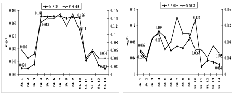
Figure 4: Nutrients content in Commercial & Fishing port and other sites of Vlora Bay.
Nitrates (N-NO3-) concentrations in all samples collected from the two ports and other sites in Vlora Bay varied from 0.018 to 0.181 mg/l. Due to the untreated urban wastes discharged into the sea. (especially close to the anchor gate of commercial port, where the untreated urban wastes of Skela area are discharged through a collector directly into the sea), the content of nitrates in both ports were higher compared to the water samples collected in the bay and lagoons. High content of nitrates in seawater is not concerning as they are the main nutrient for the aquatic biota and its intensive development causes rapid reduction of nitrates.
Nitrites (N-NO2 -) in seawater are found as intermediate compounds obtained from microbial reduction of nitrates and/or ammonium oxidation. Another possible source of nitrites might be phytoplankton and wastewater discharges. The concentration level of nitrites varied from 0.004 to 0.014 mg/l. According to EC Fish Directive 2006/44/EC [25] recommended values for nitrites are <0.03 mg/l (Cyprinid waters) that is higher than the maximum level of nitrites found in Vlora Bay.
Ammonium (N-NH4 +) might be considered as a reliable indicator of sewage discharges and livestock liquid wastes. The ammonium content was found in the levels between 0.019-0.132 mg/L. Higher levels were found in station 10 (the commercial port), as close to this station the untreated urban wastes are discharged through a collector directly into the sea.
Phosphates (P-PO4 3-): Almost all of the Phosphorus (P) present in water is in the form of phosphate (P-PO4 3-) that is an essential plant nutrient stimulating the plant (algae) growth. Its role for increasing the aquatic productivity is well recognized [26]. High levels of both phosphate and nitrate can lead to eutrophication, which increases algae growth and ultimately reduces dissolved oxygen levels in the water [26]. Phosphates in both ports were found in higher content (0.010 to 0.016 mg/L) compared to other surrounded areas in Vlora Bay. The mean value was 0.009 mg/L (Figure 4), lower than EC guide (= 0.4 mg/L for Cyprinid waters) [25].
Statistical analysis
Descriptive statistics was applied to the results obtained for the physico-chemical parameters and nutrients (Table 1). Minimal, maximal and mean values of the determined parameters are depicted in (Figure 5,6).
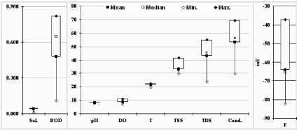
Figure 5: The box-plot of statistical data of chemical-physical parameters in seawater samples.
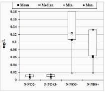
    Figure 6:  The box-plot of statistical data of nutrients content in seawater
samples.
Physico-chemical parameters presented low and moderate values of the CV% (respectively < 25% and <75%) and the values of skewness (close to 0) and kurtosis (close to 3) indicate more or less a normal distribution of these parameters by indicating stable conditions in different parts of Vlora portal area.
All the pH values (recommended value is 6-9) were within limits permitted under the EC Directive CEE 78/659 [27, 25]. TSS in water samples collected in both commercial and fishing port and other areas in Vlora Bay resulted higher than the permitted limits (recommended value is =25mg/L) due to the water currents and swelling during sample collection (samples in Vlora Bay were collected in a rainy day).
High temperature and salinity cause the oxygen to be relatively low [28]: the higher the temperature and salinity, the lower the solubility of oxygen in seawater [29]. DO was found in normal content in all samples analysed and within levels permitted under the EC Directive (= 8mg/L) [25,27]. According to the Chinese State Standard of Seawater Quality GB 3097-1997 [30] for DO and BOD content in seawater (respectively = 6 mg/L and =2mg/L), the water of the areas under investigation were clean.
The nutrients content were within limits permitted under the EC Directive CEE 78/659 [27,25]. High nutrient content were found in the stations positioned in the Commercial and Fishing Ports. The sources can be urban wastes discharged from the surrounding area, the untreated sewage discharged from the vessels and higher values of temperature.
For better interpretation of the data, the Pearson correlation coefficient (r2) is used to determine the strength of the association between two normal distributed variables. The results of correlation analysis are shown in (Table 2)
![]()
    pH
    E
    T
    TSS
    TDS
    DO
    BOD
    Cond.
    Sal.
    N-NO3-
    N-NO2-
    N-NH4+


    E
    -0.721


    T
    0.04
    -0.523


    TSS
    -0.702
    0.672
    -0.15


    TDS
    0.003
    -0.41
    0.31
    0.04


    DO
    0.35
    0.31
    -0.66
    0.04
    -0.42


    BOD
    -0.26
    -0.43
    0.742
    -0.05
    0.43
    -0.941


    Cond.
    -0.05
    -0.38
    0.31
    0.02
    0.991
    -0.45
    0.450


    Sal.
    0.25
    -0.56
    0.24
    -0.37
    0.861
    -0.29
    0.33
    0.891


    N-NO3-
    0.155
    -0.701
    0.781
    -0.43
    0.19
    -0.65
    0.821
    0.19
    0.22


    N-NO2-
    0.18
    -0.45
    0.51
    -0.43
    0.11
    -0.49
    0.51
    0.15
    0.218
    0.59


    N-NH4+
    -0.02
    -0.44
    0.841
    0.08
    0.38
    -0.47
    0.623
    0.39
    0.32
    0.693
    0.39


    P-PO43-
    0.12
    -0.661
    0.801
    -0.41
    0.27
    -0.732
    0.871
    0.27
    0.28
    0.971
    0.66
    0.663
Table 2: The results of Pearson correlation analysis.
Strong and significant correlation (P = 0.05) were found between several parameters that may indicate that the variables do indeed affect to each other. The association of the parameters with high and significant correlation is discussed together with the results of Cluster Analysis (CA).
Aiming to check the association of the parameters under investigation, the Cluster Analysis (CA) of variables (correlation coefficient distance, complete linkage and similarity level 65%) was conducted. The dendrogram of the correlation coefficients distance of nutrients and other chemical and physical parameters of seawater samples is shown in (Figure 7).
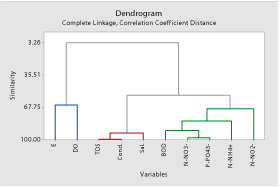
    Figure 7:  The dendrogram of CA analysis of the variables (Correlation
Coefficient Distance, Complete Linkage, Similarity level: 65%) Final Partition:
Cluster 1: TDS, Cond., Sal.; Cluster 2: BOD, N-NO3
-, N-NO2
-, N-NH4
+, P-PO4
3-
; Cluster 3: E, DO.
The dendrogram of cluster analysis based on Pearson correlation coefficients, as the measure of similarity of variables shows that the parameters under investigation are clustered into 3 groups (Complete Linkage; Correlation Coefficients Distance; Similarity level 65%).
Cluster 1 with 93% of similarity level between the parameters, is formed with the association of TDS, conductivity and salinity that are typical parameters affecting to each other.
Cluster 2 with 81% of similarity level between the parameters, is formed with the association of the nutrients (nitrate, nitrite, ammonium and phosphate) and BOD. Nutrients content in seawater are important factors causing the eutrophication of the water, and the eutrophication process is followed with the increase of the BOD.
Cluster 3 with 65.5% of similarity level between the parameters, is formed with the association of the DO and Redox Potential that reflect the red/ox condition of water. The weak similarity between these parameters is probably related to the weak reduction condition caused by the low presence of nutrients and BOD in seawater in May, just in the border of tourism and swimming period.
Conclusion
Vlora Bay presents quite suitable conditions to accommodate vessels of various types.
The physical-chemical parameters of seawater (except TSS) were found within the permitted levels. Due to rainy weather condition during sampling time, relatively high TSS content were found in Vlora Bay.
The nutrients content were within limits permitted under the EC Directive CEE 78/659. High nutrient content were found in the stations positioned in the Commercial and Fishing Ports. The sources can be urban wastes discharged from the surrounding area, the untreated sewage discharged from the vessels and higher values of temperature.
Based on nutrient content, the seawater at both ports and in Vlora Bay were oligotrophic. Small effect of harbour activity to water quality of Vlora Bay related to the small size of both ports.
Relatively high nutrient content in ports is an indicator of pollution factors that need a constant monitoring of the physical and chemical parameters to remain in control the water quality of the bay. Due to the continuous anthropogenic activities around the area and the inappropriate discharges of oil wastes or other solid and liquid wastes from the ships anchored in these ports the situation should be worse particularly during the summer period with higher temperature and high tourism activity.
References
- Diagomanolin V, Farhang M, Ghazi-Khansari M, Jafarzadeh N. Heavy metals (Ni, Cr, Cu) in the Karoon waterway river. Iran Toxicol Lett. 2004; 151: 63-68.
- Campanelli A, Fornasiero P, Marini M. Physical and Chemical characterization of the water column in the Piceno coastal area (Adriatic Sea). Fresen Environ Bull. 2004; 13: 430-435.
- Tursi A, Corselli C, Bushati S, Beqiraj S. The Vlora project. In: Tursi, A. and Corselli, C. (eds.), Coastal Research in Albania: Vlora Gulf J Coastal Res. 2011; SI 58: 1-5.
- Corsi I, Tabaku A, Nuro A, Beqiraj S, Marku E, Perra G et al. Ecotoxicological Assessment of Vlora Bay (Albania) by a Biomonitoring Study Using an Integrated Approach of Sublethal Toxicological Effects and Contaminant Levels in Bioindicator Species. J Coastal Res. 2011; 58: 116-120.
- Bird J. Seaports and seaports terminals. Hutchinson University Library. 1971; 240.
- Chubarenko B. Transboundary waters and basins in the South-East Baltic. Kaliningrad: Terra Baltica, 2008; 306 ISBN 978-5-98777-031-3.
- Lee GF, Jones-Lee A. Regulating Water Quality Impacts of Port and Harbor Stormwater Runoff. Proceedings of International Symposium Prevention of Pollution from Ships, Shipyards, Drydocks, Ports, and Harbor. 2003.
- Galkus A, Joksas K. Sedimentary material in the transitional aqua system. Institute of Georaphy: Vilnus. 1997; 198.
- Joksas K, Galkus A, Stakeniene R. The only Lithuanian Seaport and its Environment. Institute of Geology and Geography, Vilnius. 2003; 314.
- Rivaro P, Cullaj A, Frache R, Lagomarsino C, Massolo S, Maria Cristina De Mattia et al. Heavy Metals Distribution in Suspended Particulate Matter and Sediment Collected from Vlora Bay (Albania): A Methodological Approach for Metal Pollution Evaluation. J Coastal Res. 2011; 58: 54-66.
- Stoyanov S, Kozarev N, Ilieva N. Water Pollution and waste management in port areas. University of Chemical Technology and Metallurgy.
- UNEP. GESAMP: The state of the marine environment. UNEP regional seas report and status. 1990; 115: 12-16.
- Anne O, Burskyte V, Stasiskiene Z, Balciunas A. The influence of the environmental management system on the environmental impact of seaport companies during an economic crises: Lithunian case study. 2015; 22: 1072-1084.
- Bellingham K. Physicochemical parameters of natural waters. Stevens Water Monitoring Systems, Inc.
- Stakeniene R, Galkus A, Joksas K. Pollution if Klaipeda port waters. Polish J of Environ Stud. 2011; 20: 445-459.
- PHILMINAQ, Annex 2. Water Quality Criteria and Standards for Freshwater and Marine Aquaculture.
- Saravanakumar A, Rajkumar M, Sesh Serebiah J. Thivakaran GA. Seasonal variations in physico-chemical characteristics of water, sediment and soil texture in arid zone mangroves of Kachchh-Gujarat. J Environ Biol. 2008; 29: 725-732.
- Plimmer RJ. Proceedings of the workshop: Microbial degradation of pollutants in marine environments. 1978; 9-14.
- McNeely RN, Neimanis VP, Dwyer L. Water quality sourcebook: A guide to water quality parameters. Environment Canada, Inland Waters Directorate, Water Quality Branch, Ottawa. 1979. 89.
- Nemerow NL, Nelson Leonard. Scientific stream pollution analysis: New York, McGraw-Hill. 1974; 69-116.
- Tchobanoglous G, Schroeder ED. Water quality-characteristics, modeling, modification: Menlo Park, Calif., Addison-Wesley Publishing Company. 1985; 107-121.
- Boyd, Claude E. Water Quality in warm water fish ponds, Crftmaster Printer, Inc. Opelika, Alabama. 1979.
- EPA. Volunteer Estuary Monitoring, A Methods Manual. Second Edition. 2006; 14-30.
- Twomeu LJ, Piehler MF, Paerl HW. Priority Parameters for monitoring of freshwater and marine systems, and their measurement. Environmental Monitoring Vol 1.
- Council Fish Directive 2006/44/EC of the European Parliament and of the Council of 6 September 2006 on the quality of fresh waters needing protection or improvement in order to support fish life. Official Journal of the European Union.2006; 264/20-264/31.
- Murdoch T, Cheo M, O'Laughlin K. Streamkeeper's. Field Guide: Watershed Inventory and Stream Monitoring Methods. Adopt-A-Stream Foundation, Everett, WA. 2001; 297.
- Directives of European Community. BMZ (ed). Environmental Handbook: Documentation on monitoring and evaluation impacts, CEE/CEEA/CE 78/659 “Quality of fresh waters supporting fish life”, Vieweg, Leverkusen. 1995.
- Badran MI. Dissolved oxygen, chlorophyll a and nutrients: seasonal cycles in waters of the Gulf Aqaba, Red Sea, Aquat Ecosys. Health Manage. 2001; 4: 139-150.
- Fundamental of Environmental Measurements. Dossolved Oxygen.
- Wang B, Xie L, Sun X. Water Quality in Marginal Seas off China in the Last Two Decades International Journal of Oceanography. 2011.