
Abstract
This paper intended to highlight the simple, quick and reliable method to detect impending earthquake’s location. Volcanic eruption precursors are originated only around the volcanos, like that the onshore earthquake precursors are originated only from earthquake epicenter zones. Epicenter zones are earthquake zones, a little variation of fault zone, it comprises movable tectonic plates. Due to the orbital motion of the earth, centrifugal force generated, this centrifugal force is the major driving force of tectonic plates. The position of the orbital motion of the earth generated seasonal variations/atmospheric weather anomalies as onshore earthquake precursors and earthquakes, year after year repeating at same places. The generation process of seasonal weather anomalies is the part of generation process of earthquakes at epicenter zones. Both seasonal weather anomalies and seismic anomalies are not continued all through the year at same places. When earth comes to particular position, tectonic plates of particular epicenter zones are set to more active and becomes unstable epicenter zones, causes identifiable, observable, recordable and testable onshore earthquake precursors 1-15 days prior to earthquakes occur.
Keywords: Orbital motion of the earth; Centrifugal force; Stable and unstable epicenter zones; Tectonic plates; Onshore precursors; Earthquake and earthquake prediction
Introduction
Earthquakes killed over 923,000 people worldwide between 1900 and 2010 according to USGS. Greece has over 2500 years of earthquake investigation, Italy 1500 years and New Zealand over 600 years. Both deadly seasonal weather and earthquakes are Billion-dollar disasters [1]. Investigating about earthquakes and earthquake prediction studies are fascinating subject for both professional and non professional researchers. Earthquake prediction study over 120 years and the study of force move the tectonic plates over 40 years are still going on without any remarkable success. A large number of universities, research organizations, researchers and government agencies though actively involved in reliable earthquake prediction research but failed in their ultimate goal. In this empirical observational study, there over 250 epicenter zones and equal number of precursor areas have been identified worldwide. Scientists must need to understand the basic scientific knowledge about the generation process of onshore earthquake precursors and earthquakes [2,3].
Unstable epicenter zones are generates onshore earthquake precursors and earthquakes
There are two types of earthquakes: tectonic and volcanic; there are two types earthquake prediction: deterministic with known precursors and statistical with unknown precursors; there are two periods of prediction range: short term and long term; there are two zones: fault zone and epicenter zone; there are two types of epicenter zones: stable and unstable; and there are two types of precursors seismically and non-seismically related and so on. In this empirically observational earthquake prediction study based, tectonic type, deterministic, short term and unstable epicenter zone concepts.
Epicenter zones are high hazard and high-risk areas of atmospheric weather and seismic activities. Every seismically risky nation has one or more number of epicenter zones. Stable epicenter zones are under less influence of centrifugal force, so tectonic plates are less active or seismically quiescence; unstable epicenter zones, those are under the strong influence of centrifugal force, tectonic plates are seismically more active.
All form of are atmospheric seasonal weather anomalies that originated from corresponding earthquake epicenter zones due to the position of the orbital motion of earth. Different form of weather anomalies occurred at different position of epicenter zones. For a seismic zone there are more than one epicenter zones can set to activate and more than one onshore earthquake precursors are noticed. Heat wave, rainfall associated with strong winds are the most common onshore earthquake precursors. Wildfires over lakhs of acres, deadly tornadoes, snowfall, snow storms and rainfall associated with dominant in one region, so all epicenter zones are not generated same onshore atmospheric anomalies. Each and every earthquake onshore precursor generated from a corresponding earthquake epicenter zone. Based on the previously observed and recorded data base catalogue, onshore earthquake precursors generated first and followed by earthquakes at localized epicenter zone. When seasonal weather changes are repeating every year at same places means then the seismic anomalies are also strongly related with seasonal variation.
Methodology
How to predict earthquakes?
With the help of daily rainfall/snow fall map, the star icons represent the amount of rainfall and snowfall and location in geological coordinates. In this empirical observational earthquake prediction study rainfall amount equal or greater than 50mm are used to predict of impending earthquakes magnitude 4-6+.
The essential features required to predict earthquakes are: the foremost important for earthquake prediction is Direction of epicenter zone and onshore earthquake precursor, location and time and magnitude frame.
• The direction from which onshore earthquake precursor (all form of atmospheric seasonal weather anomalies) originated would be the direction of earthquake epicenter zone.
• Onshore earthquake precursor (rainfall is the best) and its location is best to identify the impending earthquake location.
• Location: Equal or within 5° latitude and within 15° longitude or 15° longitude and within 15° latitude from onshore earthquake precursor location. It varies from region to region.
• Distance from onshore earthquake precursors: usually within 15° Epicenter zone(s) are in permanent geological coordinates only precursor areas vary in exceptional cases.
• Time interval between onset of precursors and earthquakes: within 1-15 days, vary in exceptional cases.
• Magnitude: usually 4-6 also depend on the severity of the weather anomalies and site geological condition.
Direction of future earthquake location
All form of atmospheric weather anomalies are the precursor to earthquakes. There are different form of weather anomalies at different location of epicenter zones. Every epicenter zone generated more than one atmospheric weather anomalies. Most common weather anomalies are heat, rainfall associated with strong winds. Among the all form of weather anomalies rainfall location best to identify the future earthquake location.
As generalized, all form of weather anomalies are generalized as onshore earthquake precursors (Table 1).
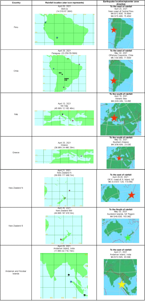
Table 1: Samples of rainfall location and earthquakes direction.
Results
Peru and Chile (Table 2)
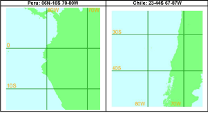
Table 2: Geological coordinates of Peru and Chile epicenter zones range.
Peru:
Number of Islands: More than 25
Number of seasonal variations: Peru has two seasons as summer and winter, but as the rainy/wet season (‘summer’) which runs from December to March, and the dry season (‘winter’) which runs from May to September.
Number of Epicenter zones: 8
1) Northern Peru; 2) Near coast of Northern Peru; 3) Central Peru; 4) Near coast of Central Peru; 5) Southern Peru; 6) Near coast of Southern Peru; 7) Peru - Ecuador border; 8) Peru - Brazil border.
Direction of Earthquakes (Epicenter zones) to the west of rainfall (Table 2a and 2b).
![]()
Precursor (rainfall) Area
Area of Epicenter zones
06N-16S 70-80WEcuador
0.01-0.06N to 02S 76 &79.36W
Peru
05-08S 74-76WNorthern Peru
04-06N 74-76WEcuador
00 55-02S 75 &78-79W
Peru
03,05&08S 73-74 &76WNear the coast of Northern Peru
05,08S 79-80WPeru
03-11S 66-73W
Colombia
04 10S 69 57W
Brazil
01-10S 45,55-56,58,61,67,69&72W
Bolivia
14S 66-67WCentral Peru
08-14S 73-76WBolivia
(11,13-19S 51,62,64-67E)
Brazil
(12-19S 46,52,56-58W
Peru
(12-13S 69&71WNear coast of Central Peru
11-16S 73-77WPeru
12-15S 69-70,74W
Bolivia
13-14S 63-68WSouthern Peru:
15-16S 70-72WPeru, Brazil & Bolivia
13-16S 62,54-67WNear the coast of Southern Peru
15-16S 73-74W
Table 2a: Samples of rainfall followed by earthquakes in previous years in Peru.
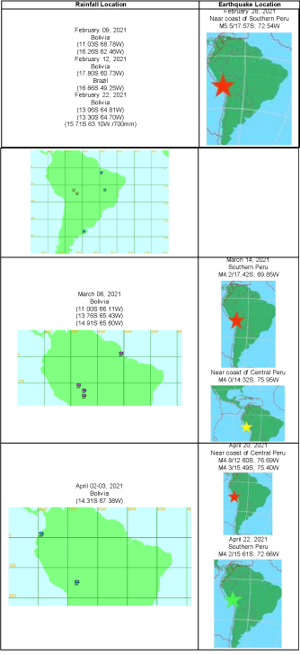
Table 2b: Samples of rainfall followed by earthquakes in 2021 in Peru.
Chile:
Number of Islands: 5,000 rocky islands.
Number of seasonal variations: There are four seasons in most of the country: summer (December to February), autumn (March to May), winter (June to August), and spring (September to November).
Number of Epicenter zones: 21
1) Tarapaca, chile; 2) Offshore Tarapaca, chile; 3) Off the coast of Tarapaca, Chile; 4) Antofagasta, Chile; 5) Coquimbo, Chile; 6) Offshore Coquimbo, Chile; 7) South coast of Coquimbo, Chile; 9) Valparaiso, Chile; 10) Offshore Valparaiso, Chile; 11) Region Metropolitana, Chile Offshore O’Higgins, Chile; 12) Libertador O’Higgins, Chile; 13) West Chile Rise; 14) Araucania, Chile; 15) Los Lagos, Chile; 16) Off coast of Antofagasta, Chile; 17) Atacama, Chile; 18) Maule, Chile; 19) Bio-Bio, Chile; 20) Magallanes, Chile; 21) Off coast of Aisen, Chile.
Direction of Earthquakes (Epicenter zones) occurs to the west of rainfall (Table 3 and 3a).
![]()
Rainfall Location
Earthquake Location
Argentina
22-23,26-2,29S 55,58-61,63,65W
Paraguay
22-25S 49,54-57,60,63WAntofagasta, Chile
23-25S 67-69WParaguay:23,25S 54,57W
Argentina:27S 58W
Brazil: 28-29S 55-57W
Uruguay:33S 55WCoquimbo, Chile
30-31S 71WArgentina, Uruguay, Paraguay & Brazil
(27-36S 52-64W)Maule:35S 75-76W
Offshore Maule, Chile:
35-36S; 72-73WArgentina
31,33-34S 68WValparaiso, Chile:
32-33S 70-71W
Maule, Chile:
35.776�S, 71.253�WArgentina
36-37S 57 &61WOffshore Valparaiso, Chile: 32-33S 71-72W
Brazil ,Argentina, Uruguay & Chile
(34-37S 54,56,59-60,,63,72,78W)Offshore Libertador O'Higgins, Chile:
33-34S 71-72WArgentina:35,38S 60,62W
Chile:33,36S 70,72WBio-Bio, Chile:
37.617�S, 73.440�W
Offshore Bio-Bio, Chile:
38.151�S, 73.730�WArgentina:34,36S 57-58,64W
Chile:39S 73WSoutheast of Easter Island:
35-36S 98,100,103WArgentina & Uruguay
(30-36S 54-59,63W)Araucania, Chile:
38-39�S, 72-73�W43,45S 71-74W
Off coast of Aisen, Chile
44-45S 75-78W42&45S 71-72W
(Argentina, Chile)West Chile rise:
40-44S 81,87,91W51,54,60,62S 58,68-69,71-72W (Argentina)
South Sandwich Islands
55-61S 25-28WChile & Argentina
45-46S 71-72WDrake passage:
57-58S 65-66WChile & Uruguay
62S 58-59W
60S 44W
Argentina
41,51S 68-69WScotia Sea
60-61S, 31,41,45,47,51W
Table 3: Samples of rainfall followed by earthquakes in previous years in Chile.
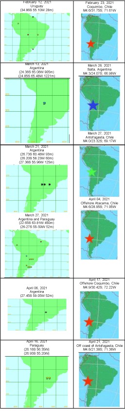
Table 3a: Samples of rainfall followed by earthquakes in recent times in Chile, 2021.
New Zealand
Number of Islands: 600
Number of seasonal variations: The rains are distributed throughout the year, with a dry summer season, in the months between December and February. Snow: Snow typically appears during the months of June through to October, though cold snaps can occur outside these months.
Number of epicenter zones:
North Island of New Zealand: 6
1) Kermadec Islands, New Zealand; 2) South of Kermadec Islands, New Zealand; 3) Off E. coast of N. Island, NZ; 4) East of North Island, New Zealand; 5) North Island of New Zealand; 6) Cook strait, New Zealand.
South Island of New Zealand: 4
1) Canterbury; 2) South Island of New Zealand; 3) Off E. coast of S. Island, N.Z; 4) Off W. coast of S. Island, NZ.
Direction of Earthquakes (Epicenter zones) occurs to the East of rainfall (Table 4-4b).
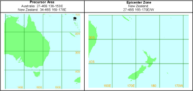
Table 4: Precursor area and epicenter zone area of New Zealand.
![]()
Precursor Area:
Australia:27-46S 138-153E
New Zealand:34-46S 169-178EEpicenter Zone
New ZealandAustralia
27-33S 149-153E
New Zealand
37-39S 176-178EKermadec Islands, New Zealand
27-30S 175-179EAustralia:
28-37S 144,147-153E,
New Zealand:
34-39S 172-178E
Heavy rain in Sydney & northern Victoria and east Gippsland:
35-38S 138,141,144,146,148-150EKermadec Islands:
27-30S 176-178W
South of Kermadec Islands:
32-35S 176-179E/WNew Zealand:
35,37-38S 174,176-177ERaoul Island, Kermadec Isl, NZ:
30.025�S 177.639�W37S 176E
- South Australia, burned
- Fire in East Gippsland
- Whale washed up Newport beach in Sydney
Off E. coast of N. Island, New Zealand:
37-38S 177-179EAustralia
37.56S 149.90E
New Zealand:
36-43S 169-174ENorth Island of New Zealand
38-40S 175-177EAustralia:
30-42S 139-151E
New Zealand:
37-45S 169-173ESouth Island of New Zealand:
42-45S 167-175E42-46S 166-170E
Wellington, NZ:
39, pilot whales stranded on NZ S Isl�s
Australia (Tasmania)
38-42S 145-148E
New Zealand
46 10S 166 38E
Forest fire in south-western Victoria, NZOff W. coast of S. Island, N.Z 45-48S 165-168E
Table 4a: Samples of rainfall followed by earthquakes in previous years in New Zealand.
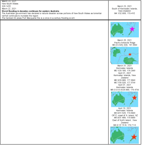
Table 4b: Overall survival, autologous stem cell transplant (ASCT) versus no ASCT (p=0.12).
Italy and Greece
Epicenter zones area.
Italy: 36-46N 07-16E
Greece: 34-40N 20-40E (Figure 1).
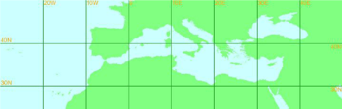
Figure 1:
Italy:
Number of Islands: The territory of Italy consists of the Appenine Penisula and roughly 450 islands. The country’s biggest island, which at the same time constitutes its largest administrative region, is Sicily.
Number of seasonal variations: Officially spring is during the months of March, April and May in Italy. Summer is from June through to August. Autumn is during the months of September, October and November and winter is from December to February.
Number of Epicenter zones: 6
1) Northern Italy; 2) Central Italy; 3) Sicily, Italy; 4) Southern Italy; 5) Adriatic Sea; 6) Tyrehenian sea.
Direction of Earthquakes (Epicenter zones) occurs to the South of rainfall (Table 5a-5c).
![]()
Rainfall Location
Earthquake Location
Italy
(38,40 &42N 13-14,16-17E) (64-118mm at 5 stans)
Italy (M)
(40-41N 08-09,12,14,17E) (51-93mm at 4 stans)Central Italy:
43.38N; 12.52ESlovenia
(45.76N 14.20E 989mm)Central Italy;
42.92N; 13.12EItaly
(42.43N 14.20E)Jan/Central Italy;
42.53N; 13.28E
Table 5a: Samples of rainfall followed by earthquakes in previous years in Italy
(Central Italy).
![]()
Rainfall Location
Earthquake Location
Italy(S)
(41.05N 15.23E 360mm)
S Italy
(39.58N 15.88E 54mm)S Italy:
41.43N; 14.43EItaly
(40.65N 17.95E 50mm)
Libyan Arab Jamahiriya
(32.08N 12.55E 59mm)
(31.86N 10.98E 325mm)Southern Italy:
41.68N; 14.82E
Sicily, Italy:
38.19N; 15.57ESW Italy
(39.58N 15.88E 62mm)S Italy:
39.812�N 16.003�E.Italy(S)
(38 12N 15 33E 59mm)Sep/M 5.3 (4.6;4.1)
Greece:
38.71N; 22.73ES Italy
(39N 16 &18E) (57-75mm)Sicily, Italy:
36.72N; 15.07EItaly(S)
(37 43N 13 26E 52.2mm)Sicily & Southern Italy:
36,38-39N; 14-15E
Table 5b: Samples of rainfall followed by earthquakes in previous years in Italy
(Southern Italy).
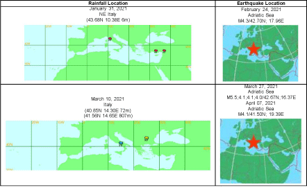
Table 5c: Samples of rainfall followed by earthquakes in 2021, Italy.
Greece:
Number of Islands: There are 6,000 or so islands scattered around the Aegean and Ionian Seas.
Number of seasonal variations:
Rainfall season: Most of the island’s rain occurs during the winter months, from October through March.
Snowfall season: During the winter much of Greece may have snow, and much snowfall can be expected in the higher mountains of Greece.
Summers in Greece: Usually very hot, and in July and August temperatures usually reach 30 to 35°C, but sometimes even 40°C and more.
Number of Epicenter zones: 9
1) Kerkira region, Greece; 2) West of Nidri, Greece; 3) Aegean Sea (E of Greece); 4) Ionian Sea (W of Greece); 5) Southern Greece; 6) Dodecanese Islands, Greece; 7) Dodecanese Is.-Turkey border reg; 8) Crete, Greece; 9) Greece
Direction of Earthquakes (Epicenter zones) occurs to the South of rainfall (Table 6a to 6e).
![]()
Precursor Area
39-42N 22-29EEpicenter zone area
39-40N 25-26EJuly 09,2013
Bulgaria
(42 12N 25 20E 68m)Aegean Sea
40.36N; 25.97ETurkey (W)
(40 58N 28 49E 200.2mm)Aegean Sea:
39.711�N, 25.630�ETurkey (NW)
(40 11N 29 04E 55.4mm)
Greece(NE)
(39 55N 25 14E 50.0mm)Aegean Sea;
39.62N; 25.55E
Table 6a: Samples of rainfall followed by earthquakes in previous years, Greece
Aegean Sea.
![]()
Turkey (W):
(37-38N 23,27-28E) (52-80mm)Dodecanese Islands, Greece:
35-36�N 26-27�E
Table 6b: Dodecanese Islands, Greece-2014 (January-June).
![]()
Precursor Area
Epicenter Zone Area
Greece(SE)
(35 29N 24 07E 77mm)Crete, Greece:
34.571�N, 24-25�EGreece
(37 42N 26 55E 60.0 mm)Crete, Greece:
34-36�N, 23-24,26�EGreece (S)
(37N 21-22E)(56-60mm)
SW Turkey
(37 02N 27 26E 57mm)Crete, Greece:
34-35N; 23,26E
Central Mediterranean Sea:
35.32N; 22.58E
Southern Greece:
37.36N; 23.02E
Table 6c: Crete, Greece.
![]()
Geological coordinates of precursor area:
38-46N 15-21EGeological coordinates of epicentre zone area:
36-40N 19-22EMacedonia
Greece (W)
(41 06N 20 49E 50mm)Greece:
40.14N; 21.84EAlbania
(40 28N 19-20E)(55- 64mm)Kerkira region, Greece:
39.864�N, 19.747�EYugoslavia
(43-44N 20-21E) (55-70mm at 5 stans)
Italy
(41 03N 15 14E 52mm)W of Nidri, Greece:
38.696�N 20.535�EBosnia and Herzegovina
(43 21N 17-18E 65.3mm)
Yugoslavia
(42 26N 18-19 &21E 80mm)
Croatia(Greece W)
(42 34N 18 16E 53.2mm)
Macedonia
(41 45N 22 11E 74mm)
Greece(N)
40 27N 21 17E 345mm)
Greece (W)
(38 37N 20 46E 329.9mm)Greece (SW):
38.675�N, 21.121�E
38.03N; 21.35EBosnia and Herzegovina
(43-44N 16-17E 124.2mm
Croatia
(44 06N 15 21E 52.2mm),
Yugoslavia
(42 46N 18 57E 68mm )Ionian Sea:
37.334�N, 20.811�ECroatia
(42 34N 18 16E 56.8mm)Greece:
37-38�N, 22-23�EBosnia and Herzegovina
(43 21N 17 48E 65.5mm)
Yugoslavia
(42N 18-19E)
Croatia
(42 34N 18 16E 76.5mm)Southern Greece:
36.515�N, 22.917�E
Table 6d: Greece West.
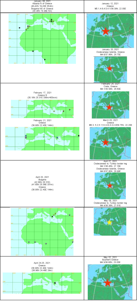
Table 6e: Few Samples of rainfall followed by earthquakes in 2021, Greece.
Andaman and Nicobar Islands
Number of Islands: 572
Number of seasonal variations: Monsoon or rainy season, lasting from June to September. The season is dominated by the humid southwest summer monsoon, which slowly sweeps across the country beginning in late May or early June.
Number of Epicenter zones: 2
Direction of Earthquakes (Epicenter zones) occurs to the East of rainfall (Table 7-7d) (Figure 2).
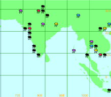
Figure 2:
![]()
Precursor Area
Area of Epicenter Zones
Andaman
08-21N 72-102E10-18N 92-95E
Nicobar Islands
06-11N 75-101E06-09N 92-95E
Table 7: Geological coordinates precursor area and epicenter zones.
![]()
Precursor Area
Epicenter Zone
Andhra Pradesh, S India (For Andaman) (16-17N 82-83E) (146mm)
India
(19.08N 82.03E 56mm)May/M 5.9 Bay of Bengal:
18.24N; 88.05EIndia; Jagdalpur
(19 05N 82 02E)Andaman Islands, India:
14.427�N, 93.417�EAndaman Islands:
11 40N 92 43E
Tropical Cyclone Three
Wind: 40 MPH - Location: 15.9N 87.7EAndaman Islands, India:
13.851�N, 93.655�E (8-11 days)Flood in India
Orissa (20-21&23N 85-87E), Andhra Pradesh (17&26N 83&88E).Andaman Islands, India:
12-13�N, 95�ETropical Cyclone Lehar
08.1N 97.1E; wind: 85mphAndaman Islands, India:
11.45N; 93.63ECold wave conditions over south Indian states Tamilnadu and North Interior Karnataka.
SE of Port Blair, Andaman Islands, India: 10.619�N, 94.117�E.
Heavy rain in different parts of Tamilnadu, S India. Temperature crosses 100°F in four districts.
(08 29N 76 57E) and (11 40N 92 43E)
S India
(12-13N 74,77 & 80E)
(11 40N 92 43E)Andaman Islands, India:
10.601�N, 93.889�E
Table 7a: Samples of rainfall followed by earthquakes in previous years, Andaman Island.
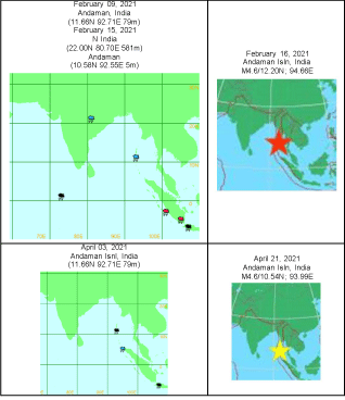
Table 7b: Samples of rainfall followed by earthquakes in 2021, Andaman, India.
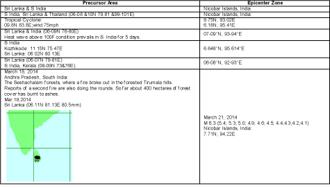
    Table 7c: Samples of rainfall followed by earthquakes in previous years, Nicobar
Islands, India.
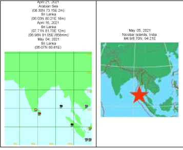
    Table 7d: Samples of rainfall followed by earthquakes in 2021, Nicobar Islands,
India.
Conclusion
Both atmospheric weather anomalies and earthquakes are repeating every year at same places to the corresponding epicenter zones with respect to the position of the orbital motion of the earth.
This empirically observed earthquake research prediction study provides the strong evidence of connection between atmospheric weather anomalies and earthquakes.
Same earthquake prediction method applied for same and different places of different continents; similar results observed. This method also best suitable to warn individual and populations of earthquakes.
Epicenter zones generated onshore earthquake precursors are identifiable, observable, verifiable and testable for any seismic regions.
This empirical research based on observed and measured phenomena from actual experience.
Acknowledgment
I whole heartedly submitted my findings that beneficial to the entire humankind at the feet of great saint, His Holiness Maha Maha Periyava. I would like to pay my greatest regards to (late) Prof. Dr. K.V Gopalakrishnan, IIT, Madras, Mrs. Vasantha Gopalakrishnan, Mr. K.V.G. Sundararaman, Oracle, New Delhi, India, Mrs. Padma, California, USA, Dr. P. Srinivasulu, SERC, CSIR, Madras (Retd), Mrs. Malayhi Srinivasan, V. D. Nagarajan, N. Malarkodi Nagarajan, (late) M. Kalidas Managing Director, KEL, Tiruchi, Tamilnadu (I was worked in the Mechanical Destructive Lab) India and my parents; wife P. Bhuvaneswari , my daughters P. Aparna and P. Aravindha and well-wishers for their affectionate support to my continuous hectic 35 years of earthquake prediction study and 12 years of continuous data observations of both atmospheric weather changes and earthquake events, though they are not experts in this field.
I would like to show my whole-hearted gratitude to (late) Dr. V. Shantha, Chairman, Adyar, Cancer Institute, Chennai. Dr. Venkatraman Radhakrishnan, Department of Medical Oncology, Dr. Aravind Krishnamurthy, Department of Surgical Oncology, and B. Gopinath, Adyar Cancer Institute (WIA), Chennai, India where I am taking the best medical treatment and helping me to get second lease of life to serve this humanity.
I also immensely grateful to Dr. Michael Blanpied, NEPEC Secretary, USGS and Dr. Jermey Zechar, CSEP, USA for sharing their pearls of wisdom during the course of this observational research and Dr. Jeremy Zechar, who arranged his students to test my hypothesis. Also, my sincere thanks to Prof. Dr. R. Chandramohan, Research Advisor, Vidhyaa Giri College of Arts and Science, Puduvayal- Tamilnadu State, India and Prof. Dr. A.T Ravichandran, Department of Physics, National College, Tiruchi, Tamilnadu, India for valuable suggestions in this observation research study.
I could not do this historic landmark achievement beneficial to the entire humanity without the support data source of the websites (http://severe.worldweather.wmo.int/rain/b5/); (http://www.emsccsem. org/Earthquake/world/M4/); www.wunderground.com/ hurricane.
References
- Pillai SP. Era of Unpredictable Earthquakes to Predictable: A New Perspective to Predict Earthquakes to Mitigate Loss of Life and Destruction of Property in Japan, California and Mexico. Austin Environ Sci. 2021; 6: 1054.
- Pillai SP. Breakthrough in Earthquake Prediction a New Perspective: Philippines and Taiwan. Austin J Earth Sci. 2021; 4: 1022.
- Prakash Pillai. Exploring E Turkey: Rainfall Precursor Predicts 100% Earthquake in a Consistent Manner in Just 2 Weeks. International Journal of Geosciences. 2013; 4.