
Abstract
It is the most arduous and challenging task to observe and record the geological coordinates of earthquake precursor locations and the corresponding epicenter zones, in Indonesia - the largest archipelago in the world and Caribbean regions. For the convenience of observational earthquake prediction study, active seismological regions of Indonesia have been divided into 10 major epicenter zones- Northern Sumatra, Southern Sumatra, Sunda Strait, Jawa, Kalimantan, Northern Sulawesi, Southern Sulawesi, Maluku and Irian Jaya, Papua and Nusatenggara. Indonesia is in the Indian and Pacific Ocean, whereas the Caribbean regions are in the Atlantic Ocean side, though they are in three entirely different regions but all the seismically active regions are having the same generation process of all form of atmospheric weather and earthquakes, is the most significant findings in this observation study since 1985. This wonderful observation study over 35 years confirms strongly confirms the strong generational process scientific relation between atmospheric weather and seismic anomalies. Observational data for different Ocean regions simply identifies the impending earthquake locations based on rainfall locations.
Keywords: Orbital motion of the earth; Centrifugal force; Stable and unstable epicenter zones; Major and minor epicenter zones; Direction of epicenter zones; Tectonic plates; Onshore precursors; Earthquake and earthquake prediction
Introduction
From ancient times to modern times, earthquakes have been the leading cause of death from natural disasters and have imposed dramatic cultural, economic, and political impacts on society. Most quakes are small. As many as 500,000 detectable earthquakes occur each year. Nearly 100,000 of them are strong enough to be felt, and only about 100 of them cause damage. They usually occur in the upper 10 miles or so of the Earth’s crust, and they’re concentrated along the boundaries where tectonic plates meet.
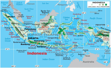
Figure 1: Indonesia Geological map: Geological coordinates of Indonesia is within 10N -10S 90-140E.
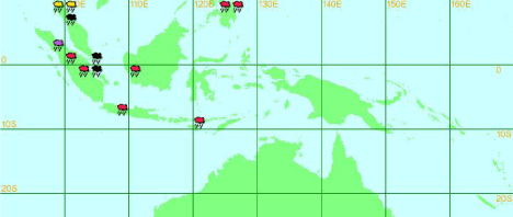
Figure 2: Star indication representation of Rainfall (equal or greater than 50mm) /snow location map, (10 degree longitude study offers best result).
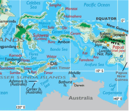
Figure 3: Northern Sulawesi.
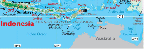
Figure 4: Nusatenggara (8-10S 110E-120E).
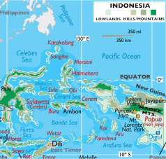
Figure 5: Maluku and Irian Jaya and Papua.
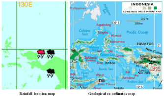
Figure 6: Papua 130-140E.
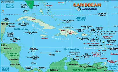
Figure 7: Caribbean Regions.
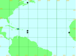
Figure 8: Rainfall location coordinates of Caribbean Regions.
Earthquakes killed over 923,000 people worldwide between 1900 and 2010 according to USGS. Greece has over 2500 years of earthquake investigation, Italy 1500 years and New Zealand over 600 years. Both deadly seasonal weather and earthquakes are billiondollar disasters. It is imminent to understand the generation process of earthquakes before to predict reliably and successfully. Global earthquakes have uniform generation process- orbital motion of the earth, generation of centrifugal force, drive the tectonic plates, generation of atmospheric weather anomalies and earthquakes. The earth crust comprises 7 major plates and 7 minor plates. Each seismic region comprises one or more major epicenter zones,and each major epicenter zone comprises one or more minor epicenter zones. Epicenter zones are earthquake zones, comprises one or more movable tectonic plates. Epicenter zones are in permanent position and they do not tend to shift from one place to other. So, the direction of epicenter zones would be the direction of earthquakes. All earthquakes are occurring in a repeatable manner at the pre-existing epicenter zones with respect to the position of the orbital motion of the earth.
This observational earthquake prediction study fourth in series of Austin Journal of Publications (AJES), focuses on understanding the generation process of atmospheric weather anomalies and generation process of earthquake phenomena. All forms of generation process of atmospheric weather anomalies are the part of the generation process of earthquakes. In this way all forms of atmospheric weather anomalies are the diagnosable earthquake precursors.
This observational study further enhanced the detection techniques of impending earthquakes by introducing new concept of major and minor epicenter zones. There are over 250 major and minor epicenter zones have been identified. Every seismic region contains one or more major epicenter zones and every major epicenter zones contains one or more minor epicenter zones. For instance, main islands of Indonesia are Sumatra, Jawa, Kalimantan, Sulawesi and Papua. Most of the main Islands are seismically contains several active major epicenter and minor epicenter zones. So, earthquakes are occurring at one or more minor epicenter zones. In this paper minor epicenter zones of Northern and Sumatra regions have been recorded for other seismic regions range of minor epicenter zones recorded. Epicenter zones are permanent in their position and have direction. In this way, this observational earthquake prediction study. So, the basic parameters for earthquakes prediction include direction of epicenter zones from precursor location in addition to location frame, time frame and magnitude frame.
It would be impossible to estimate precise time of earthquake occurrence of particular magnitude because several earthquakes of lower magnitude earthquakes could have been occur before the expected magnitude. Tectonic plates are behaves like metals, so , each regions of tectonic plates have different yield point, tensile point and break point. Experts should focus on understanding the mechanical properties of tectonic plates of different seismically active epicenter zones. For instance, earthquakes occur within 10 days after rainfall (earthquake precursor) but in other regions it takes usually within two weeks or sometimes takes over two weeks. Simultaneous break of more than one tectonic plate of more than one minor epicenter zones of a particular major epicenter zone of seismological regions may be the reason for strong earthquakes.
The amount of energy expended for the generation process of atmospheric weather anomalies and the energy released in the corresponding earthquakes would be different for different regions.
Methodology
Both atmospheric weather anomalies and earthquakes are origin wise strongly inter-related; both events are repeating every year at same place to the corresponding epicenter zones with respect to the position of the orbital motion of the earth. Without tectonic plate motion of the epicenter zones there will be no generation of atmospheric weather anomalies and earthquakes. All form of atmospheric weather anomalies are the precursor to earthquakes. There is different form of weather anomalies at different location of epicenter zones. Every epicenter zone generated more than one atmospheric weather anomalies. Most common weather anomalies are heat, rainfall associated with strong winds. Among the all form of weather anomalies rainfall or snowfall location best to identify the future earthquake location.
The essential earthquake prediction parameters in this empirical observation study based on six main steps:
• Number of Islands
• Number of major and minor epicenter zones
• Types of seasonal variations
• Geological coordinates of both of onshore precursor area and epicenter zones.
• Samples of both events in recent times
• The magnitude of the resulting earthquakes usually M4-6 are established based on observation of entire epicenter zones different seismically active regions.
Earthquake prediction strategy
On the rainfall/snow fall map (Table 1 - 3), the star icons represent the rainfall amount equal or greater than 50mm and location. Identify the direction of epicenter location based on observation. In this observation data table left column for precursor location and right column for corresponding earthquakes location.
Time, magnitude, location and Direction of future earthquake location:
There are different directions of epicenter zone of different seismic regions for Indonesia.
• The direction from which onshore earthquake precursor (all form of atmospheric seasonal weather anomalies) originated would the direction of earthquake epicenter zone.
• Location: Equal or within 5° latitude and within 15° longitude or 15° longitude and within 15° latitude from onshore earthquake precursor location. It varies region to region.
• Distance from onshore earthquake precursors: usually within 15°
• Time lag between onset of precursor and earthquake occurs: within 15 days
• Magnitude: usually 4-6. Precise time of earthquakes occurrence not possible because minor to strong earthquakes is having same generation process. In general, based on strength of cyclone, severity of rainfall and snow fall in this observation study it is estimated within 15 days after rainfall.
However, based on yield point, tensile point and break point of tectonic plates of epicenter zones of different seismically active regions to be studied for precise time of tectonic plates break.
Daily rain fall/snow fall map used in this observational study of earthquake prediction
In this observational study of earthquake prediction several weather web sites have been referred. Among them https:// severeweather.wmo.int/rain/b6/index.html map is extensively used in this earthquake prediction observation study. The amount (severity of the atmospheric weather anomalies) and geological coordinates of rainfall/snowfall is very much helpful to identify the geological coordinates of corresponding earthquake location and to estimate the size of the impending earthquakes. So, this website is primarily used for the entire regions of the world only additional confirmation other weather web sites have been referred.
There are three series of frames of wmos as “A” series frames, “B” series frames and “C” series frames. Each series has 6 frames and there are totally 18 frames. The star icons are the representation of rainfall/snowfall location. The rainfall amounts equal or greater than 50mm and coordinates location.
Results
Indonesia
Every year, more than 1000 earthquakes with varying magnitudes occur in Indonesia, ranging from minor to great earthquakes.
Indonesia:
Number of Islands: Indonesia is the largest archipelago in the world. It consists of five major islands, Sumatra,
Java, Kalimantan (Indonesian Borneo), Sulawesi, Papua and about 30 smaller groups. There are total numbers of 17,508 islands of which about 6000 are inhabited.
The largest islands are
Seasons: Weather in Indonesia can be split into two seasons - wet and dry - with warm tropical temperatures averaging 28°C during the day, throughout the year. In most regions, the dry season spans from May to September, with the rains falling between October and April. There are some regional exceptions.
Number of Islands: The region, situated largely on the Caribbean Plate, has more than 700 islands, islets, reefs and cays (see the list of Caribbean islands).
Number of epicenter zones
Season: In terms of seasons, these are divided into two main types; the high season which runs roughly from mid-December through mid-April, and the low season which runs from June through November. In addition there are two shoulder seasons in the spring and autumn. The low season is also the hurricane season in the Caribbean.
Most of the Caribbean experiences hot and humid weather with heavy rain all year round. During certain times of year, the lowpressure zones of the eastern Caribbean Sea help create hurricanes that often damage the coast and low-lying parts of the region’s islands.
Conclusion
The most significant findings in these observational studies are successfully identified the permanent major and minor epicenter zones and their directions. This only possible by observational study.
There are more than 250 permanently positioned major and minor epicenter zones have been identified at different continents.
Researchers missed to link atmospheric anomalies with seismic anomalies. Actually, the generation process of atmospheric anomalies is part of the generation process of earthquakes and generated prior to earthquakes.
Monitoring onshore earthquake precursors connection with earthquakes at same place of observations of many individual and populations of earthquakes were analyzed for a complete understanding of these phenomena.
To verify the correctness of observed results, same epicenter zone concept has been applied for different epicenter zones of different continents produce similar satisfactory results.
Epicenter zones generated onshore earthquake precursors are identifiable, observable, verifiable and testable repeatedly for any seismic regions.
There are variety of epicenter zone generated precursors of various severity and earthquakes of size of earthquakes; variety of individual or populations of earthquakes from permanent epicenter zones of different parts of the world.
This empirical research based on observed and measured phenomena from actual experience.
Seismically highly hazardous and risky different regions have been studied that reveals uniform unstable epicenter zones generated onshore earthquake precursors and earthquakes, time lag between precursor and earthquakes; direction frame; distance frame; time frame and magnitude frame.
So, the disaster management authorities have enough time to plan to mitigate the loss of life and property.
It should be scientifically more appropriate that earthquake prediction study should be the combined with Astrophysics and Geophysics, rather than seismology a part of the Geology.
Except precise time of earthquake occurrence all others generation process of onshore earthquake precursors and earthquakes generating epicenter zones have been identified is the major significant of this empirical observation of earthquake prediction.
The answer to the large earthquakes and tsunami is relying on the position of the orbital motion of the earth. World of Earthquake prediction research centers can improve earthquake prediction methodology with the advanced technology.
Acknowledgments
I whole heartedly submitted our findings that beneficial to the entire humankind at the feet of great saint, His Holiness Maha Maha Periyava. I would like to pay my greatest regards to (late) Prof. Dr. K.V Gopalakrishnan, IIT, Madras, Mrs. Vasantha Gopalakrishnan, Mr. K.V.G. Sundararaman, Oracle, New Delhi, India, Mrs. Padma, California, USA, Dr. P. Srinivasulu, SERC, CSIR, Madras (Retd), Mrs. Malathi Venkatasubramani, V.D Nagarajan. N. Malarkodi Nagarajan, M.V Sundaram Pillai, M.V Chidambaram Pillai, Subbaiya Pillai Arunachalam, (late) C. Murugeswaran, (late) G. Dharmarajan, (late) M. Kalidas Managing Director, KEL, Tiruchi, Tamilnadu (I was worked in the Mechanical Destructive Lab)., India and my beloved parents; wife P. Bhuvaneswari, my daughters P. Aparna and P. Aravindha and well-wishers for their affectionate support to my continuous hectic over 35 years of earthquake prediction study and 12 years of continuous data observations of both atmospheric weather changes and earthquake events, though they are not experts in this field.
I would like to show my whole-hearted gratitude to (late) Dr. V. Shantha, Chairman, Adyar, Cancer Institute, Chennai. Dr. Venkatraman Radhakrishnan, Department of Medical Oncology, Dr. Aravind Krishnamurthy, Department of Surgical Oncology and B. Gopinath, Adyar Cancer Institute (WIA) ,Chennai, India where I am taking the best medical treatment and helping me to get second lease of life to serve this humanity.
I also immensely grateful to Dr. Michael Blanpied, NEPEC Secretary, USGS and Dr. Jermey Zechar, CSEP,USA for sharing their pearls of wisdom during the course of this observational research and Dr. Jeremy Zechar, who arranged his students to test my hypothesis. Also, my sincere thanks to for valuable suggestions in this observation research study.
We could not do this historic landmark achievement beneficial to the entire humanity without the support data source of the websites:
(http://severe.worldweather.wmo.int/rain/b5/),
(http://www.emsc-csem.org/Earthquake/world/M4/),
www.wunderground.com/hurricane.
References
- Prakash Pillai S. How to Predict Earthquakes by Using Simple and Reliable Method? Peru, Chile, Italy, Greece, New Zealand, Andaman and Nicobar Islands, India. Austin Environ Sci. 2021; 6: 1059.
- Pillai SP. Era of Unpredictable Earthquakes to Predictable: A New Perspective to Predict Earthquakes to Mitigate Loss of Life and Destruction of Property in Japan, California and Mexico. Austin Environ Sci. 2021; 6: 1054.
- Pillai SP. Breakthrough in Earthquake Prediction a New Perspective: Philippines and Taiwan. Austin J Earth Sci. 2021; 4: 1022.
- Prakash Pillai. Exploring E Turkey: Rainfall Precursor Predicts 100% Earthquake in a Consistent Manner in Just 2 Weeks. International Journal of Geosciences. 2013; 4.